


Ready to explore The New York Central Fitness Trail ? Here's everything you need to know before you go!
Discover the trail

Trail description
The New York Central Fitness Trail offers a refreshing escape into nature without venturing far from urban conveniences. This well-maintained 7-kilometer trail winds through the diverse landscapes of New York's North Country region, combining gentle terrain with strategically placed fitness stations for a unique outdoor experience that appeals to hikers, runners, and families alike.
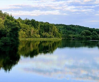
What sets this trail apart is its thoughtful design as both a hiking destination and an outdoor fitness circuit. The path meanders through dense woodlands where towering trees create a natural canopy overhead, then opens into sunny meadows that provide welcome breaks from the forest shade. Serene streams accompany portions of the route, adding the soothing sound of flowing water to your journey. With only 30 meters of elevation gain spread across the entire distance, the terrain remains accessible while still offering enough variety to keep the experience engaging.
Trail Experience and Terrain
The trail's gentle slopes make it perfect for a leisurely walk, though more energetic hikers can easily pick up the pace for a solid workout. The varied terrain keeps things interesting—you'll transition from soft forest floor carpeted with fallen leaves to firmer packed earth in the open sections. The path is wide enough for comfortable walking and well-marked throughout, eliminating any concerns about navigation.
During fall, this trail truly shines as the surrounding forest explodes into vibrant displays of red, orange, and yellow foliage. The contrast between the colorful canopy and the clear streams creates particularly striking scenery that makes autumn the most popular season for visitors. Spring brings its own rewards with wildflowers dotting the meadows and fresh green growth throughout the woodlands.
The fitness stations are thoughtfully integrated into natural clearings along the route, allowing you to pause for stretching or strength training exercises without feeling disconnected from the natural environment. These stations enhance rather than detract from the hiking experience, offering a chance to engage different muscle groups while surrounded by nature's tranquility.
Wildlife and Natural Features
Wildlife encounters add an element of excitement to every visit. Deer are frequently spotted in the early morning and late afternoon hours, often grazing in the meadow sections before bounding gracefully back into the forest cover. Rabbits dart across the path with surprising regularity, and the diverse bird population provides constant entertainment for those who bring binoculars.
The variety of bird species reflects the trail's diverse habitats—woodland birds like woodpeckers and nuthatches in the forested sections, while open-area species prefer the meadow portions. The streams attract additional wildlife, creating small ecosystems where patient observers might spot frogs, various insects, and the occasional turtle.
Planning Your Visit
Allow 2 to 3 hours for the complete trail experience, though this timeframe can vary significantly depending on how much time you spend at the fitness stations and whether you choose to linger at the more scenic spots. Many visitors find the picturesque clearings perfect for extended breaks or picnic lunches, so packing food can easily extend your visit into a half-day adventure.
The trail's family-friendly nature makes it an excellent choice for introducing children to hiking. The manageable distance, minimal elevation gain, and interesting fitness stations help keep younger hikers engaged throughout the journey. The wide path accommodates strollers on most sections, though some of the fitness station areas may require brief detours.
Water is essential since no fountains or facilities exist along the route. The 7-kilometer distance and potential 3-hour duration make adequate hydration particularly important, especially during warmer months. Weather can change throughout the day, so layered clothing proves invaluable for maintaining comfort as you move between shaded forest sections and sunny open areas.
Connections and Community
The trail connects to a broader network of outdoor recreation opportunities in the region. Nearby parkrun York and trail parkrun events provide organized running opportunities for those interested in community-driven fitness activities. These events offer excellent ways to meet fellow outdoor enthusiasts while exploring the area's natural beauty.
For those looking to extend their adventure beyond this single trail, the nearby Ontario Township of Russell offers additional hiking opportunities. Eadie Road and other trails in that area provide different terrain and scenery, making it possible to plan multi-day exploration of the broader region.
Environmental Considerations
The trail's popularity requires conscious effort from all visitors to preserve its natural beauty. Staying on designated paths protects the surrounding vegetation and prevents erosion that could damage the trail for future users. The Leave No Trace principle is particularly important here—pack out everything you bring in, including food scraps that might attract unwanted wildlife to the trail.
Respecting wildlife means observing from a distance and avoiding any attempts to feed animals. The deer, rabbits, and birds you encounter are wild creatures that maintain their health through natural foraging, and human food can actually harm their digestive systems and alter their natural behaviors.
The New York Central Fitness Trail succeeds in combining physical activity with natural beauty in a way that feels neither forced nor artificial. Whether you're seeking a peaceful solo hike, an active family outing, or a unique fitness experience, this trail delivers a satisfying outdoor adventure that showcases the natural splendor available in New York's North Country region.
The Essential Hiking Checklist
Everything you need for your next hike. Bilingual, printable, 1 page.
Get your free hiking checklistRecommended gear for this trail
As an Amazon Associate I earn from qualifying purchases.


Ready to go?
Everything you need to know before you goStarting Point
the new york central fitness trail has several trailheads you can access. One primary starting point is located at the intersection of Route 5 and Route 167 in Little Falls, NY. Another accessible trailhead is at the Herkimer Home State Historic Site, which can be found at 200 State Route 169, Little Falls, NY. Both locations offer parking facilities for visitors looking to explore the trail.
When?
How much?
As an Amazon Associate I earn from qualifying purchases.
Affiliate links — LGPO may earn a commission at no extra cost to you.
- Hiking shoes Essential
- → Salomon Elixir Tour Mid WP · 203.38 $
- Layered clothing Essential
- Rain jacket Essential
- Trekking poles
- → Black Diamond Trail Ergo Cork · 69.99 $
- Headlamp
- → Petzl Actik Core 625 · 103.95 $
FAQ - Frequently asked questions
Everything you need to knowSimilar hikes nearby
Discover other trails you might enjoy

Hiking near Sydney
22 trails to explore ~7530 km away
We work hard to provide the most up-to-date and error-free data possible. If something seems incorrect, let us know! Your contribution helps the whole community.
Hikers' opinions
Be the first to review!
No hiker has shared their experience yet. Share your impressions and help other hikers!