

Ready to explore Madonna Peak, Vermont? Here's everything you need to know before you go!
Discover the trail
Trail description
Description
Madonna Peak sits at the heart of Smugglers' Notch Resort in north-central Vermont, offering one of the more rewarding summit experiences in the region. While the mountain is best known as a ski destination in winter, the trails that wind up to its peak give hikers a genuine alpine feel without requiring a full expedition. The terrain is rugged in the best way — rooted, rocky, and honest — and the views from the top make the effort worthwhile.
The Mountain and Its Setting
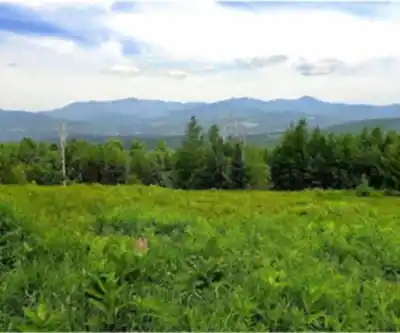
Madonna Peak stands at 3,664 feet (1,109 meters) above sea level and is the highest of the three peaks at Smugglers' Notch Resort, located in Lamoille County. That elevation translates directly into the kind of open, exposed summit that hikers come looking for. The landscape up here is classic northern Vermont: dense hardwood and conifer forest on the lower slopes giving way to more exposed terrain as you gain elevation. The upper mountain has a raw, windswept character that feels a world away from the valley below.
The area sits within the broader landscape of the Green Mountains, a range that defines the spine of Vermont. Madonna Peak benefits from that geography — the ridgeline position means you're getting views in multiple directions once you break out of the treeline near the top. The mountain is part of the Sterling Range and sits along the Long Trail, a famous thru-hike in Vermont.
The Hiking Experience
Accessing Madonna Peak on foot means navigating trails that were built for a mountain that takes its terrain seriously. The routes up are not groomed or manicured — expect exposed roots, loose rock sections, and grades that will get your heart rate up. This is a hike that rewards people who are comfortable on uneven ground and who don't mind working for their views.
The forest on the lower sections of the mountain is dense and shaded, which makes for a pleasant climb on warm days. As you move higher, the canopy opens up and the trail becomes more exposed. Near the summit, you'll find the kind of rocky, open ground that's typical of Vermont's higher peaks — a good place to stop, catch your breath, and take in what you've earned.
The summit itself offers broad views across the Green Mountain landscape. On a clear day, the panorama stretches out in a way that puts the scale of Vermont's hill country into perspective. It's the kind of view that makes you want to stay longer than you planned.
Terrain and Trail Conditions
The trails on Madonna Peak reflect the mountain's dual identity as both a ski resort and a hiking destination. Some routes follow ski runs — open, grassy corridors in summer — while others cut through the woods on more traditional footpaths. Both types have their appeal, but the wooded trails tend to feel more like a true backcountry experience.
Trail surfaces vary considerably depending on where you are on the mountain. Lower sections can be muddy after rain, and Vermont's spring mud season (typically April into May) can make conditions genuinely difficult. Summer and early fall are the prime seasons for hiking here. Late September and October bring the added bonus of fall foliage, and Madonna Peak's elevation means the color change often arrives a bit earlier than in the valleys below.
Winter hiking is possible for those with the right gear and experience, but the active ski resort operation means you'll need to be aware of what's happening on the mountain before heading out in the colder months.
What Makes Madonna Peak Stand Out
A lot of Vermont's popular hiking destinations sit within state forests or on land managed by the Green Mountain Club. Madonna Peak is different — it's a working ski resort, and that shapes the experience in ways that are both practical and atmospheric. The infrastructure of the resort (lifts, lodges, access roads) is visible from parts of the trail, but it doesn't diminish the hike. If anything, the contrast between the resort's built environment and the raw summit terrain above it is part of what makes this place interesting.
The peak also benefits from its position within the Smugglers' Notch area, one of the more dramatic corners of Vermont. The Notch itself — the narrow mountain pass nearby — has a long history as a smuggling route and a place of genuine geographic character. Hiking Madonna Peak puts you in the middle of that landscape in a way that a drive through the Notch simply doesn't.
Practical Information
Access to Madonna Peak trails runs through the Smugglers' Notch Resort property. It's worth checking in with the resort before your visit to confirm current trail access, any seasonal closures, and parking arrangements. Resort operations can affect trail availability, particularly during ski season transitions and special events.
- Best seasons: Summer through mid-fall, with peak conditions typically from late June through October
- Foliage timing: The higher elevation means fall color often peaks earlier than surrounding lower terrain
- Trail surface: Mix of rooted forest paths and open ski run corridors — sturdy footwear recommended
- Mud season: Spring conditions (April–May) can be challenging; trails may be wet and slippery
- Resort access: Check with Smugglers' Notch Resort for current trail access and parking details before visiting
- Weather: Summit conditions can change quickly — the upper mountain is exposed and wind-prone
- Long Trail access: Madonna Peak lies along the Long Trail, Vermont's famous thru-hike route
Who This Hike Is For
Madonna Peak is a solid choice for hikers who want a genuine summit experience in north-central Vermont without committing to a full-day wilderness expedition. The terrain is challenging enough to feel rewarding but not so technical that it requires specialized skills or equipment. Hikers who are comfortable on rocky, rooted trails and who have reasonable fitness will find this a satisfying outing.
It's less suited to casual walkers looking for a flat, easy stroll — the mountain doesn't offer that. But for anyone who wants to earn a real Vermont summit view and experience the character of the Green Mountains up close, Madonna Peak delivers exactly that.
Recommended gear for this trail


Ready to go?
Everything you need to know before you goStarting Point
To access the hiking trails, you can start at the main trailhead located at the base area parking lot. The address for this trailhead is 4323 Vermont Route 108 South, Jeffersonville, VT 05464. There are no additional trailheads for these specific trails.
When?
How much?
- Hiking shoes Essential
- → Salomon Elixir Tour Mid WP · 203.38 $
- Layered clothing Essential
- Rain jacket Essential
- Trekking poles
- → Black Diamond Trail Ergo Cork · 69.99 $
- Headlamp
- → Petzl Actik Core 625 · 103.95 $
FAQ - Frequently asked questions
Everything you need to knowThe Essential Hiking Checklist
Everything you need for your next hike. Bilingual, printable, 1 page.
Download the free checklistSimilar hikes nearby
Discover other trails you might enjoy

Vermont Association of Snow Travelers
Central Vermont
Northern Forest Canoe Trail
Central Vermont
Sterling Pond Trail
Central Vermont
Moss Glen Falls
Central Vermont
Lake Mansfield Trout Club
Central Vermont
Mill Trail
Central Vermont
Hiking near Stowe
0 trails to explore ~12 km away
We work hard to provide the most up-to-date and error-free data possible. If something seems incorrect, let us know! Your contribution helps the whole community.
Hikers' opinions