

Ready to explore Mount Ellen, Vermont? Here's everything you need to know before you go!
Discover the trail


Trail description
Description
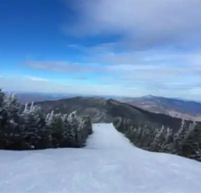
Mount Ellen stands as one of Vermont's most accessible 4,000-footers, rising 4,083 feet above the Mad River Valley in Washington County's Green Mountains. This prominent peak offers hikers multiple route options and serves as a key waypoint along Vermont's legendary Long Trail. The mountain's position in the range creates a dramatic ridgeline that defines the eastern edge of the Mad River Valley.
Mount Ellen's position alongside Lincoln Peak means the slopes share terrain with Sugarbush Ski Resort during winter months. The nearby Mad River Glen, famous for its vintage single chairlift and ski-only policy, adds to the area's distinctive character.
Trail Routes and Distances
Mount Ellen offers multiple approaches via the Long Trail system. Web sources confirm route options ranging from 8.2 miles (solo Mount Ellen) to 12.6 miles (including extended ridge traverses). The most commonly referenced route is approximately 14.3 km with 1,244 m total elevation gain.
From Lincoln Gap, the southern approach follows the Long Trail north and can incorporate Mount Abraham and additional peaks before reaching Ellen's summit. This represents the longer end of documented hiking options in the area.
Alternative approaches exist from Appalachian Gap and other trailheads. The Long Trail's ridge walking between peaks offers varied terrain and multiple ways to structure your hike depending on time and fitness level. Gap-to-gap through-hikes remain possible with shuttle arrangements.
Trail Conditions and Terrain
The Long Trail across Mount Ellen features typical Green Mountain terrain with some notable characteristics. While the peak doesn't rise above treeline, several sections along the ridges remain exposed to weather, particularly the strong northwesterly winds common to this area.
Trail surfaces vary from well-maintained footpath to rocky, rooted sections typical of Vermont's mountains. You won't encounter difficult stream crossings, but prepare for some steep sections. The ridge walking between peaks offers relatively moderate grades with occasional short, steep pitches.
Seasonal Considerations
Mount Ellen provides four-season hiking opportunities, each with distinct characteristics. Spring brings the notorious Vermont mud season, when trails become soft and potentially damaging to hike. Early summer means dealing with black flies and mosquitoes, so pack insect protection and consider long sleeves during peak bug season.
Summer and early fall offer the most comfortable hiking conditions, with those refreshing northwesterly winds helping to moderate temperatures and clear away bugs. The exposed ridge sections become assets during hot weather, providing cooling breezes and occasional views.
Winter transforms Mount Ellen into a different mountain entirely. Snow shoes and crampons become essential gear, along with full winter hiking equipment including extra layers, navigation tools, and emergency supplies.
Accommodations and Camping
The Long Trail system provides shelter options along the route. Glen Ellen Lodge offers accommodation between General Stark Mountain and Mount Ellen. The Green Mountain Club maintains detailed information about camping regulations and shelters along the Long Trail system.
For car camping, Vermont offers numerous campgrounds throughout the region. Vermont State Parks operates several facilities within reasonable driving distance of Mount Ellen's trailheads.
Practical Information
No permits, fees, or parking passes are required for hiking Mount Ellen, making it an accessible option for spontaneous adventures. Parking is available at trailheads, though spaces can fill during peak foliage season and busy summer weekends.
The mountain's location provides good access to services and amenities. Weather can change rapidly on the ridges, so prepare for conditions more severe than valley forecasts suggest. Strong winds, sudden temperature drops, and precipitation changes are all common, particularly during transitional seasons.
Recommended gear for this trail


Ready to go?
Everything you need to know before you goStarting Point
To access the hiking trails, you can start at the Jerusalem Trailhead, located on Jim Dwire Road in Starksboro. Alternatively, you can begin at the Appalachian Gap Trailhead on Vermont Route 17 in Waitsfield. Both trailheads provide parking facilities for hikers.
When?
How much?
- Hiking shoes Essential
- → Salomon Elixir Tour Mid WP · 203.38 $
- Layered clothing Essential
- Rain jacket Essential
- Trekking poles
- → Black Diamond Trail Ergo Cork · 69.99 $
- Headlamp
- → Petzl Actik Core 625 · 103.95 $
FAQ - Frequently asked questions
Everything you need to knowThe Essential Hiking Checklist
Everything you need for your next hike. Bilingual, printable, 1 page.
Download the free checklistAlternatives and suggestions
Similar hikes nearby
Discover other trails you might enjoy

Vermont Association of Snow Travelers
Central Vermont
Northern Forest Canoe Trail
Central Vermont
Sterling Pond Trail
Central Vermont
Moss Glen Falls
Central Vermont
Lake Mansfield Trout Club
Central Vermont
Mill Trail
Central Vermont
Hiking near Montpelier
0 trails to explore ~30 km away
We work hard to provide the most up-to-date and error-free data possible. If something seems incorrect, let us know! Your contribution helps the whole community.
Hikers' opinions