

Ready to explore Mount Mansfield-The Forehead, Vermont? Here's everything you need to know before you go!
Discover the trail
Trail description
Description
Mount Mansfield is Vermont's highest peak, and the Forehead is one of its most accessible and rewarding summits. Sitting along the ridgeline of the mountain's famous "face" profile — which gives each summit its name — the Forehead offers hikers a genuine above-treeline experience without committing to the full traverse. It's a destination that earns its reputation, combining open rocky terrain, sweeping views, and a real sense of being up high in the Green Mountains.
The Terrain
The approach to the Forehead takes you through classic Vermont forest — northern hardwoods giving way to boreal spruce and fir as you gain elevation. The trail gets progressively more rugged as you climb, with exposed roots, rocky steps, and sections that require hands-on scrambling near the top. This isn't a casual stroll, but it's well within reach for hikers who are comfortable on uneven terrain and don't mind working for their views.
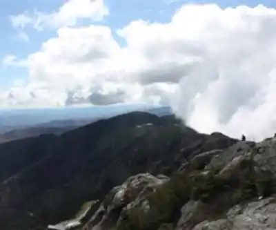
As you break out of the trees near the summit, the landscape shifts dramatically. The Forehead sits at the southern end of Mount Mansfield's alpine zone, and the vegetation here is fragile and rare — low-growing plants clinging to thin soil between the rocks. The Green Mountain Club and Vermont's Agency of Natural Resources manage this area carefully, and hikers are asked to stay on marked trails and rock surfaces to protect the alpine ecosystem.
The Views
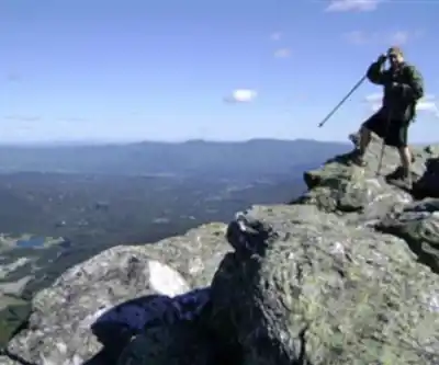
From the Forehead, the panorama opens up in multiple directions. To the west, you're looking out over the Champlain Valley toward the Adirondacks in New York. To the east, the Worcester Range and the rolling hills of central Vermont stretch out below you. On a clear day, the visibility is exceptional — this is genuinely one of the better viewpoints in the state, and the open rocky summit gives you room to move around and take it all in without feeling crowded onto a single ledge.
Looking north along the ridgeline, you can see the rest of Mount Mansfield's profile — the Nose, the Chin (the true summit), and the Adam's Apple — laid out in front of you. It gives you a strong sense of the mountain's scale and makes the Forehead feel like a natural starting point if you're considering a longer ridge traverse on a future visit.
What Makes the Forehead Distinct
Mount Mansfield as a whole is a well-known destination, but the Forehead specifically attracts hikers who want the alpine experience without the full commitment of reaching the Chin. It's a legitimate summit with real above-treeline terrain, not just a viewpoint partway up. That distinction matters — you're not stopping short, you're choosing a specific objective that stands on its own.
The Forehead also tends to be slightly less crowded than the Chin, particularly on busy summer and fall weekends. If you're looking for a quieter experience on the mountain, timing your visit to the Forehead rather than pushing all the way to the highest point can make a noticeable difference.
Trail Conditions and Seasonal Considerations
The upper sections of the trail can be wet and slippery even in dry conditions — the boreal forest holds moisture, and the rocks near the summit can be treacherous when wet. Sturdy footwear with good grip is strongly recommended. Trekking poles are useful on the descent, especially on the steeper rocky sections.
The alpine zone on Mount Mansfield is one of the few places in Vermont where true arctic-alpine plants survive. This ecosystem is extremely sensitive to foot traffic, and the Green Mountain Club posts caretakers on the mountain during the hiking season specifically to help protect it. When a caretaker asks you to step back onto the rock, they're not being difficult — the plants growing in those cracks can take decades to recover from a single footstep.
Winter access to the Forehead is possible for experienced hikers with appropriate gear, but the conditions above treeline can be severe and change rapidly. The exposed ridgeline is fully open to wind and weather, and what feels manageable in the trees can become genuinely dangerous on the summit rocks.
Practical Information
- Location: Mount Mansfield, Vermont — the Forehead is the southernmost named summit on the mountain's ridgeline.
- Managed by: Vermont Department of Forests, Parks and Recreation, in partnership with the Green Mountain Club.
- Alpine zone rules: Stay on marked trails and bare rock surfaces above treeline. Do not step on alpine vegetation.
- Footwear: Sturdy hiking boots are strongly recommended — trail runners are workable for experienced hikers, but the rocky terrain rewards ankle support and solid grip.
- Dogs: Dogs are permitted but must be kept under control. Be mindful of other hikers on narrow sections of trail.
- Leave No Trace: Pack out all waste. There are no facilities on the upper mountain.
Getting There
Mount Mansfield is located near Stowe, Vermont, and is accessible via several trailheads depending on your chosen route to the Forehead. The mountain is well-signed and well-documented — the Green Mountain Club's trail maps and the Vermont Department of Forests, Parks and Recreation both provide current access information, including any seasonal road closures or permit requirements that may apply. Checking conditions before you go is always a good idea on a mountain this size.
Parking at the main trailheads can fill up early on summer weekends and during peak fall foliage season — arriving before 8 a.m. gives you a much better chance of finding a spot and having a quieter experience on the trail.
Recommended gear for this trail


Ready to go?
Everything you need to know before you goStarting Point
To access the hiking trails, you can start at several trailheads:
Underhill State Park: 352 Mountain Road, Underhill Center, VT 05490. This is a popular starting point with parking available.
Smugglers' Notch State Park: 6443 Mountain Road, Stowe, VT 05672. Another option with parking facilities.
Stevensville Trailhead: End of Stevensville Road, Underhill, VT 05489. Limited parking is available here.
Ensure to check for any seasonal road closures or parking restrictions before your visit.
When?
How much?
- Hiking shoes Essential
- → Salomon Elixir Tour Mid WP · 203.38 $
- Layered clothing Essential
- Rain jacket Essential
- Trekking poles
- → Black Diamond Trail Ergo Cork · 69.99 $
- Headlamp
- → Petzl Actik Core 625 · 103.95 $
FAQ - Frequently asked questions
Everything you need to knowThe Essential Hiking Checklist
Everything you need for your next hike. Bilingual, printable, 1 page.
Download the free checklistSimilar hikes nearby
Discover other trails you might enjoy

Vermont Association of Snow Travelers
Central Vermont
Northern Forest Canoe Trail
Central Vermont
Sterling Pond Trail
Central Vermont
Moss Glen Falls
Central Vermont
Lake Mansfield Trout Club
Central Vermont
Mill Trail
Central Vermont
Hiking near Stowe
0 trails to explore ~12 km away
We work hard to provide the most up-to-date and error-free data possible. If something seems incorrect, let us know! Your contribution helps the whole community.
Hikers' opinions