

Ready to explore Sterling Mountain, Vermont? Here's everything you need to know before you go!
Discover the trail
Trail description
Description
Sterling Mountain (3,714 ft) sits in the Green Mountains of northern Vermont near Johnson, rising above the surrounding landscape with the kind of quiet authority that draws hikers back season after season. This is classic Green Mountain terrain — forested ridgelines, rocky outcrops, and that particular stillness you only find when you've earned some elevation. Whether you're a local looking for a solid half-day outing or a visitor exploring what northern Vermont has to offer on foot, Sterling Mountain delivers a genuinely rewarding experience.
The Terrain
The approach to Sterling Mountain takes you through dense northern hardwood and boreal forest typical of Vermont's higher elevations. As you gain altitude, the tree cover shifts — sugar maples and yellow birches give way to spruce and fir, a transition that signals you're getting somewhere. The trail surface varies: expect rooted, rocky sections that keep you honest and remind you to watch your footing, especially after rain or during the shoulder seasons when mud and wet leaves can make things slippery.
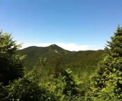
The upper reaches of Sterling Mountain open up enough to reward the effort with views that stretch across the surrounding ridges and valleys. On a clear day, the perspective from the higher terrain gives you a real sense of the layered topography that defines this part of Vermont — rolling forested hills folding into one another as far as you can see.
What to Expect on the Trail
Sterling Mountain isn't a casual stroll, but it's also not the kind of hike that requires technical skills or specialized gear. It sits in that satisfying middle ground where you'll feel the climb in your legs without ever feeling like you're in over your head. The trail demands attention and a reasonable baseline of fitness, making it a solid choice for hikers who've moved past beginner terrain and want something with a bit more substance.
Footing is the main thing to stay mindful of. The rocky and rooted sections that characterize much of the trail require steady, deliberate steps — particularly on the descent, when tired legs and loose rocks are a combination worth respecting. Trekking poles are worth bringing if you use them.
The forest itself is part of the experience. Sterling Mountain's trail corridor passes through mature woodland that feels genuinely wild, the kind of place where you're likely to hear more birds than people on a weekday morning. Keep an eye out for the wildlife that moves through this landscape — Vermont's forests support a healthy mix of species, and the transition zones between different forest types on the mountain are particularly active habitat.
Seasonal Considerations
Vermont's seasons shape the Sterling Mountain experience in meaningful ways. The best times to visit are June through October. Summer offers the most straightforward conditions — trails are generally dry, the forest canopy provides shade, and the longer days give you flexibility. Fall is arguably the peak season for this kind of hike: the foliage in northern Vermont is genuinely spectacular, and Sterling Mountain's elevation puts you right in the middle of the color show as the hardwoods turn.
Spring hiking on Sterling Mountain comes with the classic Vermont caveat: mud season is real. The freeze-thaw cycle tears up trail surfaces, and some sections can be deeply rutted and saturated well into May. If you're hiking in spring, check conditions beforehand and be prepared to turn around if the trail is taking a beating from foot traffic.
Winter access depends on snowpack and your gear. Snowshoes or microspikes are typically necessary once the mountain gets its seasonal snow cover, and the shorter days mean you'll want an early start.
Getting There and Practical Details
Sterling Mountain is located near Johnson in northern Vermont's Green Mountains, accessible via the road network that serves this part of the state. As with many Vermont trailheads, the final approach may involve unpaved road sections — a vehicle with reasonable clearance is helpful, particularly in wet conditions or early spring.
Parking at the trailhead is the standard starting point for most hikers. Arrive early on weekends during peak foliage season, as popular Vermont trailheads fill up faster than people expect.
- Footwear: Waterproof hiking boots with ankle support are strongly recommended given the rocky, rooted terrain.
- Water: Carry enough for the full outing — don't count on reliable water sources on the trail without a filter.
- Layers: Temperatures at elevation in Vermont can drop quickly, even in summer. A wind layer and something warm are worth the extra weight in your pack.
- Navigation: Download an offline map or carry a paper topo before you head out. Cell service in this area of Vermont is inconsistent.
- Leave No Trace: Stay on the marked trail, pack out everything you bring in, and give wildlife plenty of space.
What Makes Sterling Mountain Worth the Trip
Northern Vermont has no shortage of hiking options, but Sterling Mountain earns its place on the list for a few specific reasons. The forest quality is high — this isn't second-growth scrub but mature, layered woodland that feels like real backcountry even if you're not far from civilization. The elevation gain gives the hike genuine character without pushing into the kind of commitment that requires a full expedition-style approach. And the views from the upper terrain offer the kind of wide, uncluttered perspective that reminds you why people have been drawn to Vermont's hills for generations.
It's the kind of hike that fits naturally into a Vermont weekend — challenging enough to feel like an accomplishment, accessible enough that you're not wrecked for the rest of the trip.
Recommended gear for this trail


Ready to go?
Everything you need to know before you goStarting Point
To access the hiking trails, you can start at one of several trailheads. Here are the options:
Sterling Pond Trailhead: Located at the top of Smugglers' Notch on Route 108. Parking is available at the designated lot near the trailhead.
Long Trail Access: You can also begin your hike from the Long Trail, which intersects with various points along Route 108. Look for parking areas along this route.
Smugglers' Notch Resort: Some trails can be accessed from the resort area, where parking is available for visitors.
Ensure to check local maps and signs for specific directions and any seasonal road closures that might affect access.
When?
How much?
- Hiking shoes Essential
- → Salomon Elixir Tour Mid WP · 203.38 $
- Layered clothing Essential
- Rain jacket Essential
- Trekking poles
- → Black Diamond Trail Ergo Cork · 69.99 $
- Headlamp
- → Petzl Actik Core 625 · 103.95 $
FAQ - Frequently asked questions
Everything you need to knowThe Essential Hiking Checklist
Everything you need for your next hike. Bilingual, printable, 1 page.
Download the free checklistSimilar hikes nearby
Discover other trails you might enjoy

Vermont Association of Snow Travelers
Central Vermont
Northern Forest Canoe Trail
Central Vermont
Sterling Pond Trail
Central Vermont
Moss Glen Falls
Central Vermont
Lake Mansfield Trout Club
Central Vermont
Mill Trail
Central Vermont
Hiking near Stowe
0 trails to explore ~14 km away
We work hard to provide the most up-to-date and error-free data possible. If something seems incorrect, let us know! Your contribution helps the whole community.
Hikers' opinions