

Ready to explore Mount Mansfield? Here's everything you need to know before you go!
Discover the trail
Trail description
Description
Mount Mansfield is Vermont's highest peak, and it earns that title in every sense. This is a serious mountain — rugged, exposed, and genuinely rewarding for hikers who come prepared. Located in the northern part of the Green Mountains, it draws everyone from seasoned ridge-walkers to curious first-timers, though the terrain makes clear pretty quickly that this isn't a casual stroll.
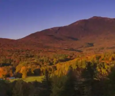
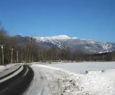
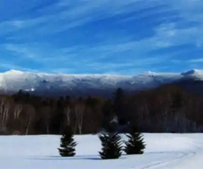
The mountain's silhouette is one of the most recognizable in the Northeast. When you look at it from the Champlain Valley to the west, the ridgeline traces the profile of a human face lying on its back — the Forehead, the Nose, the Chin, and the Adam's Apple are all distinct summits along the ridge. The true summit is the Chin, and that's where most hikers are headed when they set out for the top.
The Terrain
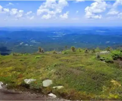
Getting to the summit of Mount Mansfield means working through a variety of terrain depending on which route you take. Lower on the mountain, you're moving through dense northern hardwood and boreal forest — yellow birch, sugar maple, and balsam fir dominate. As you gain elevation, the trees shrink and thin out, and eventually you break out onto open rocky terrain near the ridge.
The upper ridge and summit area are genuinely alpine — a rare ecosystem in Vermont. The Chin sits above treeline, and the exposed rock and tundra-like vegetation up there feel more like the Canadian Rockies than what most people expect from New England. That exposure also means weather can shift fast. Wind, fog, and cold temperatures are common even in summer, so layers and rain gear are worth packing regardless of what the forecast says at the trailhead.
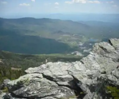
The rock itself is rough and grippy in dry conditions, but becomes slick when wet. Footing requires attention throughout, especially on steeper sections and near the summit where the trail crosses open ledge.
The Alpine Zone
One of the most important things to know before hiking Mount Mansfield is that the summit ridge hosts a fragile alpine ecosystem. The plants growing in the tundra zone — including rare mosses, lichens, and low-growing shrubs — are extremely slow to recover from foot traffic. Staying on marked trails and on bare rock when you're above treeline isn't just a suggestion; it's critical to keeping this ecosystem intact.
The Green Mountain Club and the Vermont Department of Forests, Parks and Recreation manage the summit area, and summit caretakers are typically stationed on the mountain during the hiking season to help visitors navigate the ridge responsibly. If you see a caretaker up there, they're a great resource — they know the mountain well and can point you toward the best spots while keeping you off the sensitive vegetation.
Access and Trailheads
There are multiple ways to reach the summit of Mount Mansfield, and the route you choose will shape your whole experience. The most popular trailheads are accessed from Stowe, which sits on the eastern side of the mountain. The Long Trail runs along the ridge and connects the various summit points, so many hikers use it as the backbone of their route.
The Toll Road and the Gondola at Stowe Mountain Resort offer alternatives to hiking the full elevation gain from the base — the Gondola in particular drops you close to the ridge, making the summit accessible to people who wouldn't otherwise be able to reach it. If you're going the full hiking route from a lower trailhead, expect a significant climb with sustained effort over rocky, rooted trail.
Parking is available at several trailheads in the area. Trailhead lots can fill up early on weekends and holidays during peak season, so an early start is genuinely useful — both for parking and for avoiding the busiest stretch of the day on the upper ridge.
What to Expect on the Ridge
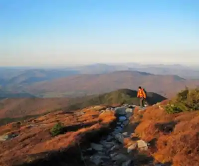
Once you're on the summit ridge, the views open up in every direction. On a clear day, you can see Lake Champlain and the Adirondacks to the west, and the rolling Green Mountains stretching south. The ridge walk between the Forehead and the Chin covers exposed terrain with some scrambling involved — it's not technical climbing, but you do need to use your hands in places and pay attention to where you're stepping.
The Chin itself is marked and easy to identify. It's a satisfying place to stop — wind-scoured, open, and genuinely high. The sense of being on top of Vermont is real up there.
The Nose is accessible via the Toll Road area and offers its own views without requiring the full ridge traverse. It's a good option if you want a taste of the upper mountain without committing to the full summit push.
Practical Information
- Season: The hiking season typically runs from late spring through fall. Winter travel on the upper mountain requires mountaineering experience and appropriate gear — the summit ridge is fully exposed and conditions can be severe.
- Fees: There may be fees associated with certain access points, including the Toll Road. Check current information before you go, as these can change seasonally.
- Dogs: Dogs are permitted on the hiking trails but must be kept under control. The alpine zone requires extra care — keep dogs on trail to protect the vegetation.
- Leave No Trace: Pack out everything you bring in. There are no garbage facilities on the mountain.
- Water: Carry enough water for your full outing. Water sources on the upper mountain are limited.
- Cell service: Spotty to nonexistent in many areas. Download offline maps before you leave.
Who It's Right For
Mount Mansfield is best suited to hikers who are comfortable on uneven, rocky terrain and who have some experience with longer, more demanding outings. The alpine zone and exposed ridge make it a genuinely memorable destination — but the mountain asks something of you in return. Come with solid footwear, real layers, and enough time to move at a comfortable pace without rushing the descent.
For families with younger kids or hikers looking for a more moderate experience, the Gondola access and the area around the Nose offer a way to experience the upper mountain without the full commitment of a summit hike from the base.
Recommended gear for this trail


Ready to go?
Everything you need to know before you goStarting Point
The start of the trails at the mount mansfield, vermont is located at the summit of the mountain.
When?
How much?
- Hiking shoes Essential
- → Salomon Elixir Tour Mid WP · 203.38 $
- Layered clothing Essential
- Rain jacket Essential
- Trekking poles
- → Black Diamond Trail Ergo Cork · 69.99 $
- Headlamp
- → Petzl Actik Core 625 · 103.95 $
FAQ - Frequently asked questions
Everything you need to knowThe Essential Hiking Checklist
Everything you need for your next hike. Bilingual, printable, 1 page.
Download the free checklistSimilar hikes nearby
Discover other trails you might enjoy

Arthur Park
Champlain Valley
Eagle Mountain Natural Area
Champlain Valley
Sunset Ridge Trail
Champlain Valley
Causeway Park
Champlain Valley
Burton Island State Park
Champlain Valley
Saxon Hill Bike Trail
Champlain Valley
Hiking near Stowe
0 trails to explore ~13 km away
We work hard to provide the most up-to-date and error-free data possible. If something seems incorrect, let us know! Your contribution helps the whole community.
Hikers' opinions