

Ready to explore Sunset Ridge Trail? Here's everything you need to know before you go!
Discover the trail
Oh no! We don't have any photos 😢
This trail hasn't been captured yet. Be the first to share your adventure!Trail description
Description
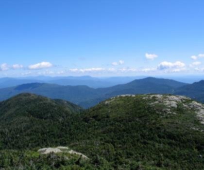
Sunset Ridge Trail is one of Vermont's most rewarding hikes, climbing through dense forest before breaking out onto an open, rocky ridgeline with sweeping views that make every step of the ascent worth it. Located in the Champlain Valley region, this trail draws hikers who want a genuine mountain experience — real elevation gain, exposed terrain, and the kind of panorama that stays with you long after you've driven home.
The Terrain
The trail starts in the trees, and for a good stretch that's exactly where you'll stay. The forest here is classic Vermont hardwood and conifer mix — maples, birches, and firs that close in around you as you climb. The footing is rooty and rocky in sections, so trekking poles are a smart call, especially on the descent when your legs are tired.
As you gain elevation, the character of the trail shifts. The trees thin out, the canopy opens up, and eventually you're walking along an exposed ridgeline where the wind picks up and the views start to open in every direction. This transition from enclosed forest to open ridge is one of the defining features of Sunset Ridge — it's a genuine payoff moment, not a gradual fade.
The ridge itself is rocky and requires some attention underfoot. Cairns mark the route across the more open sections. This isn't technical scrambling, but it's not a groomed path either — you're navigating real mountain terrain.
The Views
The ridgeline delivers some of the most expansive views in the Champlain Valley. To the west, Lake Champlain spreads out below you, with the Adirondacks rising on the far shore in New York. On a clear day, the layering of water, lowland, and distant peaks is genuinely striking. To the east, Vermont's Green Mountains fill the horizon. It's the kind of 360-degree perspective that reminds you why people hike in the first place.
The trail's name isn't accidental — the west-facing ridge catches the late afternoon light beautifully, and hikers who time their summit for late afternoon are rewarded with warm golden light across the lake and mountains. That said, plan your turnaround time carefully if you're going for sunset; descending this trail in the dark without a headlamp is not a good time.
What to Expect on the Trail
Sunset Ridge Trail is a legitimate workout. The climb is sustained, and while there are flatter sections in the lower forest, the upper portion of the trail doesn't let up much. Hikers should be comfortable on uneven, rocky terrain and prepared for the exposure on the ridge — both in terms of wind and the lack of shade once you're above treeline.
The trail sees steady use, particularly on weekends and during fall foliage season when the hardwood forest below the ridge puts on a serious show. Weekday mornings are your best bet for a quieter experience. The parking area can fill up on busy days, so arriving early is worth it.
Conditions on the upper ridge can change quickly. Even on a warm valley day, the ridgeline can be significantly cooler and windier. Bring an extra layer, and check the weather before you head out — afternoon thunderstorms are a real consideration in summer, and the exposed ridge is not where you want to be when lightning rolls in.
Seasonal Considerations
Spring hiking on Sunset Ridge means mud — Vermont's mud season is no joke, and the lower trail sections can be genuinely messy from snowmelt through late May. The upper rocky sections drain better, but the approach will test your boots.
Summer offers the longest days and the best conditions for that late-afternoon ridge walk, though heat and afternoon storm risk are real factors. Fall is peak season for good reason: the hardwood forest below the ridge turns brilliant, and the views from the top take on a whole new dimension with color in the valley below. Winter hiking is possible for those with the right gear — microspikes at minimum, crampons and an ice axe for harder conditions on the upper ridge.
Practical Information
- Trailhead access: The trailhead is located in the Champlain Valley area of Vermont. Check current access and parking details before your visit, as conditions and availability can vary by season.
- Footwear: Sturdy hiking boots with ankle support are strongly recommended. Trail runners work for experienced hikers comfortable on rocky terrain, but this is not a sneakers hike.
- Water: Carry all the water you need. Don't count on reliable water sources on the trail.
- Navigation: The route is generally well-marked, but cairns on the open ridge can be harder to follow in fog or low visibility. A downloaded map or GPS track is a good backup.
- Leave No Trace: Stay on the marked trail, especially on the fragile ridge vegetation. The alpine and sub-alpine plants up top are slow to recover from foot traffic off the path.
Who This Trail Is For
Sunset Ridge Trail is best suited to hikers with some experience under their belts — people who are comfortable on rocky, uneven terrain and don't mind a sustained climb. It's not the right choice for a first-ever hike or for young children who aren't yet steady on their feet on rough ground. For fit, experienced hikers looking for a genuine Vermont mountain experience with exceptional views over Lake Champlain and the surrounding region, it delivers exactly what it promises.
If you're visiting the Champlain Valley and want one hike that captures what makes Vermont's landscape so compelling — the forest, the elevation, the water views, the open sky — Sunset Ridge Trail belongs at the top of your list.
Recommended gear for this trail


Ready to go?
Everything you need to know before you goStarting Point
The sunset ridge trail is located in the town of Killington, Vermont. To get to the trailhead, take exit 9 from Interstate 91 and head east on Route 4. The trailhead is located at the end of Sunset Ridge Road.
When?
How much?
- Hiking shoes Essential
- → Salomon Elixir Tour Mid WP · 203.38 $
- Layered clothing Essential
- Rain jacket Essential
- Trekking poles
- → Black Diamond Trail Ergo Cork · 69.99 $
- Headlamp
- → Petzl Actik Core 625 · 103.95 $
FAQ - Frequently asked questions
Everything you need to knowThe Essential Hiking Checklist
Everything you need for your next hike. Bilingual, printable, 1 page.
Download the free checklistSimilar hikes nearby
Discover other trails you might enjoy

Arthur Park
Champlain Valley
Eagle Mountain Natural Area
Champlain Valley
Causeway Park
Champlain Valley
Mount Mansfield, Vermont
Champlain Valley
Red Rocks Park
Champlain Valley
Burton Island State Park
Champlain Valley
Hiking near Stowe
0 trails to explore ~14 km away
We work hard to provide the most up-to-date and error-free data possible. If something seems incorrect, let us know! Your contribution helps the whole community.
Hikers' opinions