

Ready to explore Mountain Loop Highway? Here's everything you need to know before you go!
Discover the trail
Trail description
The Mountain Loop Highway is one of the most scenic drives and hiking corridors in the North Cascades region of Washington State. Winding through the Cascade Mountains and running between Arlington and Granite Falls, this route connects a remarkable concentration of trails, old-growth forest, alpine lakes, and historic mining sites — all accessible from a single road that follows the South Fork Stillaguamish River and Sauk River valleys. Whether you're here for a short walk or a multi-day backcountry push, the Mountain Loop Highway delivers the kind of Pacific Northwest wilderness that keeps people coming back year after year.
What the Area Looks Like
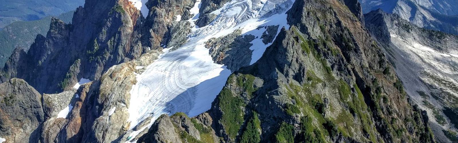
The landscape along the Mountain Loop Highway shifts dramatically as you move through it. Lower elevations are dominated by dense second-growth and old-growth forest — towering Douglas fir, western red cedar, and Sitka spruce form a thick canopy over mossy understory. As you gain elevation on the surrounding trails, the forest opens up into subalpine meadows, rocky ridgelines, and eventually the kind of exposed alpine terrain that defines the Cascades. Glacially carved valleys, rushing creeks, and jagged peaks define the skyline throughout.
The Sauk and Stillaguamish rivers run alongside much of the highway, and their gravel bars and forested banks are a constant presence. Waterfalls are common, especially in spring and early summer when snowmelt is at its peak.
Trails and Access Points
The Mountain Loop Highway isn't a single trail — it's a launching point for dozens of them. Trailheads are scattered along the highway's length, giving hikers access to everything from easy riverside walks to strenuous summit routes. Some of the most well-known destinations in the area include Glacier Basin, Monte Cristo, Big Four Ice Caves, and Heather Lake, each offering a distinct experience and difficulty level.
- Big Four Ice Caves Trail — A relatively flat, family-friendly walk through old-growth forest to the base of a steep avalanche slope where ice caves form from compacted snow. The caves themselves are unstable and entering them is dangerous, but the approach and the view of Big Four Mountain are excellent.
- Heather Lake Trail — A moderate climb through old-growth forest to a beautiful subalpine lake ringed by cliffs and heather meadows. One of the more popular destinations along the highway.
- Monte Cristo Townsite — A flat, gravel road walk leading to the ghost town of Monte Cristo, a former silver and gold mining settlement from the late 1800s. The history here is tangible — remnants of the old townsite and mining infrastructure are still visible.
- Glacier Basin — A longer, more demanding hike that climbs from the Monte Cristo area into a stunning glacial cirque. This one rewards the effort with serious alpine scenery.
- Barlow Pass — A key access point near the end of the paved section of the highway, serving as the trailhead for Monte Cristo and several other routes.
The Monte Cristo History
One of the things that sets the Mountain Loop Highway corridor apart from other hiking areas in Washington is the depth of its mining history. The Monte Cristo area was a booming silver and gold mining town in the 1890s, complete with a railroad, hotels, and a concentrator. The town went through cycles of boom and bust before being largely abandoned in the early 20th century. Today, the Monte Cristo Townsite is managed as a historic site, and the walk in gives you a real sense of what this remote valley looked like when it was an industrial hub. Interpretive signage and preserved structures help tell the story.
Road Conditions and Seasonal Access
The Mountain Loop Highway is paved for 34 miles (55 km) from Granite Falls to Barlow Pass (2349') where the highway becomes unpaved for 13 miles (21 km), and then paved again for the remaining 9 miles (14 km) to Darrington. The highway is typically open from late spring through fall, with snow closing the higher sections in winter. The exact opening date varies year to year depending on snowpack — checking current road conditions before heading out is always a good idea, especially early in the season.
Some trailheads along the highway require a Northwest Forest Pass for parking. This is worth confirming before you go, as enforcement is active and the fees support trail maintenance in the area.
Wildlife and Nature
The forests and river corridors along the Mountain Loop Highway support a wide range of wildlife. Black bears are present in the area, and proper food storage is expected on overnight trips. Deer are commonly spotted along the road and in forest clearings. The rivers and streams hold native salmon and steelhead, and bald eagles are frequently seen along the waterways, particularly during salmon runs in fall.
Birdlife in the old-growth sections is notable — pileated woodpeckers, varied thrushes, and dippers are among the species you're likely to encounter. Wildflower displays in the subalpine zones peak in mid to late summer, with lupine, paintbrush, and heather putting on a strong show on the higher trails.
Practical Tips
- Cell service is limited to nonexistent along most of the highway. Download offline maps before you leave.
- Northwest Forest Pass is required at many trailheads. Have one on hand or be prepared to purchase a day pass at the trailhead.
- Bears are active in this area. Carry bear spray on backcountry trips and use bear canisters or hang food properly if camping overnight.
- River crossings on some trails can be hazardous during high water in spring. Check conditions and use good judgment.
- The gravel section of the highway between Barlow Pass and Darrington is generally passable for standard vehicles but can be rough after heavy rain.
- Crowds peak on summer weekends, especially at popular trailheads like Big Four and Heather Lake. Arriving early or visiting on weekdays makes a noticeable difference.
Who It's Good For
The Mountain Loop Highway works well for a wide range of hikers precisely because the trail options are so varied. Families with young kids can stick to the Big Four Ice Caves trail or the Monte Cristo road walk. Intermediate hikers have solid options like Heather Lake and several ridge trails. Strong hikers looking for a full day or a backpacking trip can push into Glacier Basin or explore the more remote corners of the surrounding wilderness. The highway itself is also a legitimate scenic drive for anyone who wants to take in the Cascades without committing to a long hike.
The Essential Hiking Checklist
Everything you need for your next hike. Bilingual, printable, 1 page.
Get your free hiking checklistRecommended gear for this trail
As an Amazon Associate I earn from qualifying purchases.


Ready to go?
Everything you need to know before you goWhen?
How much?
As an Amazon Associate I earn from qualifying purchases.
Affiliate links — LGPO may earn a commission at no extra cost to you.
- Hiking shoes Essential
- → Salomon Elixir Tour Mid WP · 203.38 $
- Layered clothing Essential
- Rain jacket Essential
- Trekking poles
- → Black Diamond Trail Ergo Cork · 69.99 $
- Headlamp
- → Petzl Actik Core 625 · 103.95 $
FAQ - Frequently asked questions
Everything you need to knowSimilar hikes nearby
Discover other trails you might enjoy
Lake Chelan
Columbia Plateau
Washington Park Trail
Columbia Plateau
Little Spokane River
Columbia Plateau
Boyer Mountain
Columbia Plateau
Lummi River
Columbia Plateau

Mirror Lakes Trail
Columbia Plateau
Hiking near Sydney
22 trails to explore ~7463 km away
We work hard to provide the most up-to-date and error-free data possible. If something seems incorrect, let us know! Your contribution helps the whole community.
Hikers' opinions
Be the first to review!
No hiker has shared their experience yet. Share your impressions and help other hikers!