

Ready to explore Bowron Lake? Here's everything you need to know before you go!
Discover the trail

Trail description
Description
Bowron Lake Provincial Park sits deep in British Columbia's Cariboo Mountains, and it's one of those places that genuinely earns its reputation. The park is internationally known for its 116-kilometer canoe circuit — a chain of lakes, rivers, and portages that forms a near-perfect rectangle through the wilderness — but the hiking here is just as compelling for anyone willing to lace up their boots and head into the backcountry.
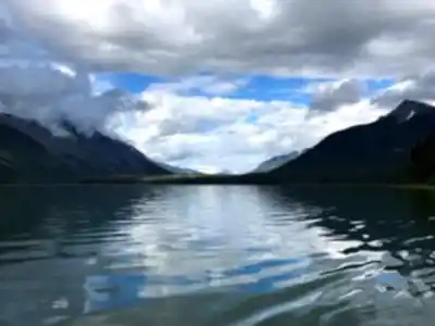
The landscape was carved by glaciers, and that history shows in every direction: crystal-clear lakes that mirror the surrounding peaks on calm mornings, broad valleys flanked by dense boreal forest, and subalpine terrain that opens up as you gain elevation. The Cariboo Mountains don't get the same attention as the Rockies, but the scenery here holds its own.
The Circuit and What to Expect
The main route through Bowron Lake covers 116 kilometers and takes most people between 6 and 10 days to complete, depending on pace, weather, and how much time you spend exploring side routes. The total elevation gain across the circuit is around 500 meters — not extreme by mountain standards, but enough to remind you that this isn't flat terrain. The difficulty is rated hard, and that rating is honest. It's not technical climbing, but the combination of distance, remote location, variable weather, and the physical demands of multi-day travel through wilderness puts this firmly in the challenging category.
The trail surfaces range from well-maintained paths near the main facilities to rougher backcountry terrain further in. Expect roots, rocks, and muddy sections — especially during spring snowmelt or after summer thunderstorms. At higher elevations, snow patches can linger well into July, so checking current conditions before you head out is always worth the effort.
Terrain and Vegetation Zones
One of the things that makes Bowron Lake interesting from a hiking perspective is how much the landscape changes as you move through it. Near the lakes, the trails wind through old-growth cedar and spruce forest, where the canopy is dense enough to feel like a different world. The forest floor is thick with moss and ferns, and the trees — massive Engelmann spruce and Douglas fir — create a quiet, cathedral-like atmosphere that's hard to find anywhere else.
As you gain elevation, the forest opens up. Mountain ash and alpine larch start to appear, and eventually you break out into subalpine meadows where wildflowers bloom in short but spectacular bursts during the mountain summer. From the higher points on the route, the views stretch across ridge after ridge of the Cariboo Mountains, with no sign of development in any direction.
Wildlife Along the Way
The park supports a genuinely diverse range of wildlife, and multi-day hikers have a good chance of encountering several species over the course of a trip. Moose are a regular sight in the marshy shallows and along the lake edges, particularly in the early morning and evening. Watching a moose wade into a lake to feed is one of those experiences that sticks with you.
Black bears are present throughout the park during the warmer months, foraging for berries, roots, and fish. They're not a constant presence on the main trails, but carrying bear spray and practicing proper food storage isn't optional here — it's just part of traveling in this kind of wilderness. Bald eagles are a common overhead sight, loons call across the lakes at dusk, and the forest is full of smaller birds during breeding season.
The lakes themselves are remarkably clear, a product of their glacial origins and the park's protected status. They support healthy populations of rainbow trout, lake trout, and kokanee salmon, which adds another dimension to the experience for anyone who packs fishing gear.
Seasonal Conditions
The hiking season at Bowron Lake generally runs from late May through early October. Spring brings fewer crowds and impressive wildflower displays, but trails can be muddy and higher routes may still be snow-covered. Summer offers the most reliable conditions — warm days, long light, and the option to combine hiking with swimming or fishing in the lakes along the route.
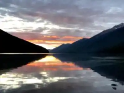
Fall is worth considering if you can manage the timing. The deciduous trees and shrubs turn yellow, orange, and red against the evergreen backdrop, and the cooler temperatures make long days on the trail more comfortable. That said, early snow at higher elevations is a real possibility by late September, so packing layers and being prepared for changing conditions is essential regardless of when you go.
Combining Hiking with Other Activities
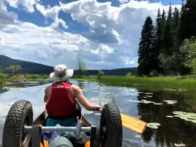
Bowron Lake is one of those parks where the experience is richer if you're open to mixing activities. The canoe circuit is the most famous way to travel through the park, and some hikers use paddling to reach trailheads that aren't accessible on foot. The park's camping facilities support extended stays, which makes it possible to tackle multiple sections of the route over several days rather than trying to rush through.
The park's position in the Cariboo Mountains — where the landscape transitions between the coastal ranges and the interior plateau — creates a biodiversity that rewards slow, attentive travel. Coastal and interior species overlap here in ways that don't happen everywhere, and that mix shows up in the plant communities, the birdlife, and the overall character of the wilderness.
For hikers looking for a genuine backcountry experience in British Columbia without venturing into the most remote corners of the province, Bowron Lake offers a rare combination: serious wilderness, meaningful distance, and enough infrastructure to make the logistics manageable.
Recommended gear for this trail


Ready to go?
Everything you need to know before you goStarting Point
The bowron lake Provincial Park is located in the Cariboo region of British Columbia. The park is about a five-hour drive northeast of Vancouver. To get to the park, take Highway 1 east to Cache Creek. From there, take Highway 97 north to Quesnel. Then take Highway 26 west to the park.
When?
How much?
- Hiking shoes Essential
- → Salomon Elixir Tour Mid WP · 203.38 $
- Layered clothing Essential
- Rain jacket Essential
- Trekking poles
- → Black Diamond Trail Ergo Cork · 69.99 $
- Headlamp
- → Petzl Actik Core 625 · 103.95 $
FAQ - Frequently asked questions
Everything you need to knowThe Essential Hiking Checklist
Everything you need for your next hike. Bilingual, printable, 1 page.
Download the free checklistSimilar hikes nearby
Discover other trails you might enjoy

Emma Lake
Cariboo Chilcotin Coast
Horn Lake
Cariboo Chilcotin Coast
Moul Falls
Cariboo Chilcotin Coast
Helmcken Falls Rim
Cariboo Chilcotin Coast
Big Bar Lake
Cariboo Chilcotin Coast
Murtle Lake
Cariboo Chilcotin Coast
Hiking near Jasper
82 trails to explore ~224 km away
We work hard to provide the most up-to-date and error-free data possible. If something seems incorrect, let us know! Your contribution helps the whole community.
Hikers' opinions