

Ready to explore Moul Falls? Here's everything you need to know before you go!
Discover the trail
Oh no! We don't have any photos 😢
This trail hasn't been captured yet. Be the first to share your adventure!Trail description
Description
Moul Falls is one of the most satisfying short hikes in Wells Gray Provincial Park, and for good reason: it's the only waterfall in the park where you can actually walk behind the falling water. Located on Grouse Creek in east-central British Columbia, Moul Falls ranks as the third highest waterfall in the park by straight, unbroken drop — and the trail that leads there packs a lot of reward into a compact 2.4-kilometer round trip.
Grouse Creek begins its journey high in the mountains, fed by snowmelt, a mountain lake, and natural springs at a pass between Trophy Mountain and Table Mountain. The creek travels westward through the wilderness before plunging dramatically over Moul Falls, then continues downstream past McDiarmid Falls and eventually joins the Clearwater River. That broader context helps explain why the waterfall carries such volume and force — by the time Grouse Creek reaches the falls, it has gathered considerable momentum.
The Trail
The hike covers 2.4 kilometers with 123 meters of elevation gain, and most people complete it in around an hour and fifteen minutes. The difficulty is rated easy, which is accurate — the trail is manageable for hikers with a basic fitness level, though the elevation gain gives it just enough of a climb to make arriving at the falls feel earned.
The path winds through dense, shaded forest for most of its length. The tree canopy keeps things cool even on warm summer days, which makes this a particularly good option when the heat elsewhere in the park is less forgiving. As you move through the forest, you'll pass several smaller waterfalls along the way — they're worth pausing for, and they build anticipation for what's ahead.
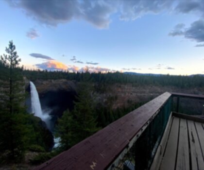
One of the trail's best moments comes when the forest opens up onto a rocky outcrop with a clear view down into the river valley. From here, you get your first full look at Moul Falls — the water dropping in a single unbroken column down the rock face. It's a strong first impression, and it sets up the experience waiting at the base.
At the Falls
The bottom of the falls is where the hike really delivers. Up close, the sheer volume of water coming off Grouse Creek is immediately apparent — the sound is loud, the mist is constant, and the air around the base is noticeably cooler than anywhere else on the trail. It's the kind of spot where people tend to linger longer than they planned.
The defining feature of Moul Falls is the small cave tucked directly behind the waterfall. Walking into it puts you in a completely different relationship with the water — you're inside the falls rather than watching from outside. The sound amplifies in the enclosed space, the mist surrounds you, and the curtain of falling water fills your entire field of view. It's a genuinely unusual experience, and it's what separates Moul Falls from every other waterfall in Wells Gray Provincial Park.
The rocky area around the base offers plenty of room to sit, eat, and take in the scene from different angles. Whether you spend ten minutes or an hour here, the combination of sound, mist, and visual scale makes it easy to just be present in the place.
What Sets This Hike Apart
Wells Gray Provincial Park has no shortage of waterfalls — it's one of the defining features of the park. But Moul Falls holds a specific distinction: it's the only one in the park that lets visitors get behind the water. That single characteristic, combined with a trail that's short enough for almost anyone to complete, makes it one of the most consistently popular destinations in the park.
The trail also does a good job of showcasing the broader landscape. The forested approach gives you a real sense of the region's dense woodland ecosystem, the rocky outcrop mid-route offers a geological contrast, and the waterfall itself is a direct expression of the water-rich environment that defines this part of British Columbia. The smaller cascades along the way reinforce that this is a creek system with a lot of energy moving through it.
The character of the falls shifts across the season. Spring snowmelt from Trophy Mountain and Table Mountain pushes the highest water volumes through Grouse Creek, making the falls at their most dramatic. Later in summer and into fall, the flow eases off, which can actually make the behind-the-falls experience more comfortable — less mist, easier footing on the wet rock.
Planning Your Visit
Because the hike is short, Moul Falls fits easily into a broader day in Wells Gray Provincial Park. The one-hour-fifteen-minute estimate leaves plenty of time to combine it with other trails or park attractions without feeling rushed.
A few practical things worth knowing: the forested trail holds moisture well, so expect muddy sections after rain or during snowmelt season. The rocks at the base of the falls and inside the cave get slippery when wet — which is essentially always, given the constant mist. Footwear with solid grip is important here, especially if you plan to explore behind the falls. The trail itself is straightforward to follow, and the elevation gain is steady rather than steep, so there are no particularly technical sections to navigate.
Photographers will find a range of perspectives available, from the wide valley view at the rocky outcrop to the close-up chaos of the base, to the unusual vantage point from inside the cave looking out through the falling water — that last one in particular is hard to replicate anywhere else in the region.
Recommended gear for this trail


Ready to go?
Everything you need to know before you goStarting Point
The start of the trails at the moul falls in British Columbia can be accessed from the parking lot located off of Highway 99.
When?
How much?
- Hiking shoes Essential
- → Salomon Elixir Tour Mid WP · 203.38 $
- Layered clothing Essential
- Rain jacket Essential
- Trekking poles
- → Black Diamond Trail Ergo Cork · 69.99 $
- Headlamp
- → Petzl Actik Core 625 · 103.95 $
FAQ - Frequently asked questions
Everything you need to knowThe Essential Hiking Checklist
Everything you need for your next hike. Bilingual, printable, 1 page.
Download the free checklistSimilar hikes nearby
Discover other trails you might enjoy

Emma Lake
Cariboo Chilcotin Coast
Horn Lake
Cariboo Chilcotin Coast
Helmcken Falls Rim
Cariboo Chilcotin Coast
Big Bar Lake
Cariboo Chilcotin Coast
Murtle Lake
Cariboo Chilcotin Coast
Bowron Lake
Cariboo Chilcotin Coast
Hiking near Jasper
82 trails to explore ~177 km away
We work hard to provide the most up-to-date and error-free data possible. If something seems incorrect, let us know! Your contribution helps the whole community.
Hikers' opinions