

Ready to explore Murtle Lake? Here's everything you need to know before you go!
Discover the trail
Oh no! We don't have any photos 😢
This trail hasn't been captured yet. Be the first to share your adventure!Trail description
Description
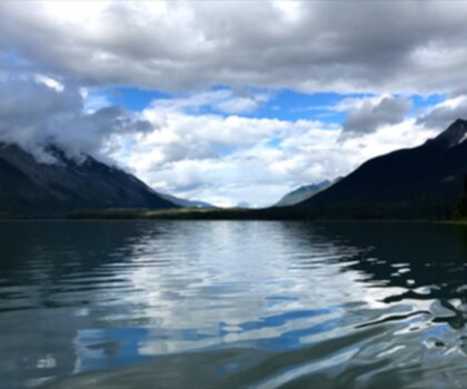
Murtle Lake is one of British Columbia's most remarkable wilderness destinations — a lava-dammed lake sitting in the heart of Wells Gray Provincial Park in east-central BC. What sets it apart isn't just the scenery, though that's genuinely stunning. It's the fact that Murtle Lake holds the distinction of being the largest lake in North America where only human-powered watercraft are permitted. No motorboats, no floatplanes. Just the sound of paddles, wind, and loons.
The lake's distinctive reversed 'L' shape creates two separate arms, each with its own character. The West Arm draws most visitors with its sandy beaches, sheltered coves, and three islands worth exploring by canoe or kayak. The North Arm pushes deep into the Cariboo Mountains like a fjord, narrowing as forested hills and rocky cliffs close in on both sides. The Wavy Range towers above the east shore of the North Arm, giving paddlers a dramatic mountain backdrop that gets more impressive the further in you go. Between the two arms, Central Mountain anchors the bend, while the Stevens Lakes valley stretches south toward Battle Mountain, adding another layer of topographical variety to an already diverse landscape.
Getting to the Lake
Access to Murtle Lake starts with a 1.5-kilometer walk from the parking area — a flat, easy trail with essentially no elevation gain. It takes about 45 minutes at a relaxed pace, and it's manageable even if you're carrying a canoe or loaded kayak to the water. The path moves through typical interior BC forest, giving you a feel for the ecosystem before you reach the shoreline. Don't let the simplicity of the access trail mislead you, though. Once you're on the water, you're in genuine wilderness, and the lake opens up into serious backcountry territory.
On the Water
The moment you push off from shore, the silence hits you. There's no engine noise anywhere on the lake — just water, birds, and whatever wind is moving through the trees. The West Arm is where most paddlers spend their time, and for good reason. The sandy beaches make for excellent rest stops and overnight camping spots, and the coves offer natural wind shelter and good wildlife watching. The three islands scattered through this section give you something to navigate toward and provide different vantage points on the surrounding mountains and shoreline.
Paddling into the North Arm is a different experience entirely. The fjord-like character becomes more pronounced as the waterway narrows, and the scenery shifts toward something more dramatic and austere. There are fewer beaches here, but the geological features and mountain views more than compensate. This section suits paddlers looking for a more remote, wilderness-focused experience.
The lake's water is clear and cold, fed by the Murtle River, which travels 18 kilometers southwest from a large unnamed glacier sitting at 2,300 meters elevation in the Cariboo Mountains. After filling the lake, the river continues another 36 kilometers southwest to join the Clearwater River. That glacier-fed system keeps the water quality high and the temperatures refreshingly cold even on warm summer days.
The Short Hiking Trail
For those who come specifically to hike rather than paddle, the trail from the parking area to the lake covers 4.8 kilometers with only 50 meters of elevation gain — rated easy, with an estimated 30-minute completion time at a steady pace. It's a straightforward out-and-back that works well for families or anyone wanting a low-key introduction to the Wells Gray backcountry. The trail itself is less about dramatic scenery and more about the payoff at the end: arriving at the edge of one of BC's most protected and pristine lakes.
Fishing and Wildlife
The lake's protected status and minimal motorized disturbance have helped maintain healthy fish populations and strong aquatic habitat. Fishing is possible here, though you'll want to check current BC regulations and licensing requirements before you go. Wildlife is present throughout the area — the forested slopes and rocky shoreline provide habitat for species typical of BC's interior mountain ecosystems. Early morning and evening are the best windows for wildlife activity near the water's edge.
Conservation Background
In 1968, roughly 40 percent of Wells Gray Park — approximately 525,680 acres — was designated as the Murtle Lake Nature Conservancy, giving this area a level of protection that goes beyond standard provincial park rules. The ban on motorboats and aircraft, established in 1970, wasn't a bureaucratic formality. It was a deliberate decision to keep this particular place as close to its natural state as possible.
That protection shapes the entire experience of being here. The absence of engine noise means you're hearing the lake the way it actually sounds — loons calling across the water, fish breaking the surface, wind moving through the shoreline trees. It's a reminder of what wilderness quiet actually feels like, and it's increasingly rare.
Visitors carry real responsibility in a place like this. Leave No Trace principles apply strictly — pack out everything you bring in, use designated camping areas, and give wildlife the space it needs. The pristine character of Murtle Lake exists because previous visitors respected those principles, and maintaining it depends on everyone who comes after doing the same.
Recommended gear for this trail


Ready to go?
Everything you need to know before you goStarting Point
The start of the trails at the murtle lake can be accessed by driving to the parking lot at the end of the road.
When?
How much?
- Hiking shoes Essential
- → Salomon Elixir Tour Mid WP · 203.38 $
- Layered clothing Essential
- Rain jacket Essential
- Trekking poles
- → Black Diamond Trail Ergo Cork · 69.99 $
- Headlamp
- → Petzl Actik Core 625 · 103.95 $
FAQ - Frequently asked questions
Everything you need to knowThe Essential Hiking Checklist
Everything you need for your next hike. Bilingual, printable, 1 page.
Download the free checklistSimilar hikes nearby
Discover other trails you might enjoy

Emma Lake
Cariboo Chilcotin Coast
Horn Lake
Cariboo Chilcotin Coast
Moul Falls
Cariboo Chilcotin Coast
Helmcken Falls Rim
Cariboo Chilcotin Coast
Big Bar Lake
Cariboo Chilcotin Coast
Bowron Lake
Cariboo Chilcotin Coast
Hiking near Jasper
82 trails to explore ~137 km away
We work hard to provide the most up-to-date and error-free data possible. If something seems incorrect, let us know! Your contribution helps the whole community.
Hikers' opinions