

Ready to explore The Enchanted Forest? Here's everything you need to know before you go!
Discover the trail


Trail description
Description
The Enchanted Forest sits tucked away in the heart of the Kootenay Rockies, offering hikers a surprisingly diverse experience packed into a compact 2-kilometer trail. Don't let the short distance fool you—this trail climbs 500 meters through varied terrain that will keep you engaged for the full 3 to 4 hours it takes most people to complete the loop.
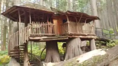
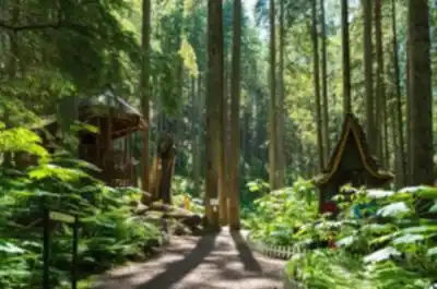
What makes this trail special is how much it delivers in such a concentrated space. You'll start among towering old-growth trees where the canopy creates a cathedral-like atmosphere, with shafts of sunlight filtering through to illuminate the forest floor. The trail surface varies from soft forest duff to rocky sections where you'll need to watch your footing, especially during the steeper climbs.
Trail Experience and Terrain
The well-maintained network of paths winds through several distinct forest environments as you gain elevation. In the lower sections, you'll walk alongside babbling brooks where the sound of moving water accompanies your steps. The trail crosses these streams at several points, so expect some moisture on the rocks during spring runoff or after recent rains.
As you climb higher, the forest composition shifts and opens up, revealing vibrant understory plants that change dramatically with the seasons. Spring brings wildflowers, summer offers lush green growth, and fall transforms the landscape into a showcase of autumn colors. The diversity of plant life creates natural photo opportunities at nearly every turn, making this a favorite spot for nature photographers.
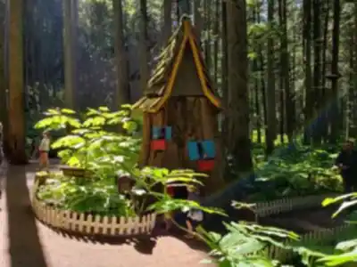
The trail's design accommodates different hiking preferences through its network structure. You can choose shorter, easier routes that stick to the lower elevations for a more leisurely experience, or tackle the full climb to reach the viewpoints. The paths are clearly marked, though the "enchanted" atmosphere comes partly from how the dense forest can make you feel pleasantly isolated from the outside world.
Wildlife and Natural Features
The forest supports a healthy population of wildlife that you're likely to encounter during your visit. Deer are commonly spotted, especially in the early morning or late afternoon hours. The diverse bird population includes both year-round residents and seasonal visitors, so bringing binoculars can enhance your experience significantly.
Keep your eyes open for smaller woodland creatures as well—squirrels, chipmunks, and various bird species are active throughout the day. The forest's ecosystem thrives partly because of its location in the Kootenay Rockies, where different elevation zones create varied habitats within a relatively small area.
The babbling brooks that follow portions of the trail aren't just scenic—they're part of a larger watershed system that keeps the forest lush and supports the wildlife populations. These water features also provide natural rest stops where you can refill water bottles if you have proper filtration equipment.
Viewpoints and Highlights
The trail's most rewarding feature is its series of viewpoints that open up as you gain elevation. These carefully positioned overlooks provide panoramic vistas of the surrounding Kootenay Rockies, offering perspective on just how vast and rugged this mountain region truly is. The contrast between the intimate forest environment and the expansive mountain views creates a unique hiking experience.
These viewpoints serve as natural rest stops and picnic spots. The elevation gain means you'll have earned these views, and the rocky outcrops provide comfortable seating areas where you can take in the scenery. On clear days, the mountain vistas extend for miles, showcasing the dramatic peaks and valleys that define this region.
The viewpoints also offer the best opportunities to understand the forest's place in the larger landscape. From these elevated positions, you can see how the forest fits into the mountain ecosystem and appreciate the geographic features that make the Kootenay Rockies such a distinctive hiking destination.
Planning Your Visit
The 3 to 4 hour timeframe accounts for a reasonably paced hike with stops for photos and rest breaks at the viewpoints. Stronger hikers might complete the trail faster, but the scenery and wildlife viewing opportunities make it worth taking your time. The elevation gain is steady rather than steep, but it's consistent enough that you'll feel the workout.
Trail conditions can vary significantly with weather and season, so checking current conditions before your visit is essential. Spring conditions may include muddy sections and higher water levels in the stream crossings. Summer typically offers the most stable trail conditions, while fall provides the best colors but potentially slippery leaves on the trail surface.
Pack more water than the distance might suggest—the elevation gain and time on trail mean you'll need adequate hydration. Snacks or a light lunch work well for the viewpoint stops. Your gear should include sturdy hiking boots for the varied terrain, and layers for changing conditions as you gain elevation.
The forest environment means you'll be mostly shaded, but the viewpoints expose you to full sun and potentially wind. A camera is nearly essential given the photogenic nature of both the forest interior and the mountain vistas. Remember to follow Leave No Trace principles to preserve the natural beauty that makes this trail such a special destination in the Kootenay Rockies.
Recommended gear for this trail


Ready to go?
Everything you need to know before you goStarting Point
the enchanted forest is located in Revelstoke, British Columbia. To get to the start of the trails, take exit 2 from Highway 1 and drive north on Mackenzie Avenue for 2 km. The trailhead will be on your right.
When?
How much?
- Hiking shoes Essential
- → Salomon Elixir Tour Mid WP · 203.38 $
- Layered clothing Essential
- Rain jacket Essential
- Trekking poles
- → Black Diamond Trail Ergo Cork · 69.99 $
- Headlamp
- → Petzl Actik Core 625 · 103.95 $
FAQ - Frequently asked questions
Everything you need to knowThe Essential Hiking Checklist
Everything you need for your next hike. Bilingual, printable, 1 page.
Download the free checklistSimilar hikes nearby
Discover other trails you might enjoy

Emerald Lake
Kootenay Rockies

Golden Skybridge
Kootenay Rockies

Mount Stephen
Kootenay Rockies
Bugaboo Provincial Park
Kootenay Rockies
Magog, Lake
Kootenay Rockies
Iceline Trail
Kootenay Rockies
Hiking near Kelowna
45 trails to explore ~138 km away
We work hard to provide the most up-to-date and error-free data possible. If something seems incorrect, let us know! Your contribution helps the whole community.
Hikers' opinions