

Ready to explore Elora Cataract Trailway? Here's everything you need to know before you go!
Discover the trail
Oh no! We don't have any photos 😢
This trail hasn't been captured yet. Be the first to share your adventure!Trail description
Description
The Elora Cataract Trailway is one of southwestern Ontario's most rewarding rail-trail experiences, stretching 47 kilometres through the agricultural heartland and natural areas of Huron, Perth, Waterloo, and Wellington counties. Built on a former railway corridor, the trail connects the historic town of Elora with the village of Cataract, offering a route that's genuinely accessible to hikers of all fitness levels while still delivering a surprising variety of landscapes along the way.
What makes this trail stand out among Ontario's many rail conversions is how much the scenery shifts as you move through it. Dense hardwood forests give way to open farmland, wetland corridors appear between stretches of rolling fields, and the occasional conservation area anchors the route with more dramatic natural features. You're rarely looking at the same thing for long, which keeps the experience engaging even on sections where the terrain itself stays flat.
Trail Surface and Terrain
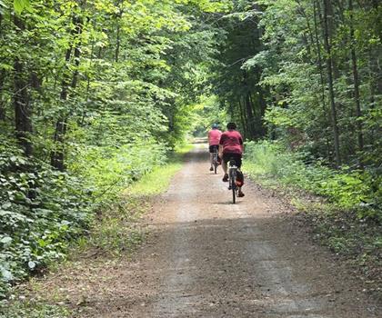
The railway heritage delivers a well-maintained crushed stone surface for most of the route, with grades so gentle they're barely noticeable underfoot. This makes the trail genuinely comfortable for novice hikers, families with young children, and anyone who wants to cover distance without technical challenges. The wide corridor also means good sightlines in most directions, which helps when sharing the path with cyclists or the occasional equestrian.
Forested sections feature mature maples, oaks, and birches that form a natural canopy overhead. These stretches feel enclosed and cool even on warm days, and the tunnel effect becomes particularly striking in fall when the leaves shift to deep oranges and reds. In contrast, the open agricultural sections expose you to wide prairie-like views across working farmland — a reminder that this trail runs through some of Ontario's most productive countryside.
Wetland areas punctuate the route at several points, and these tend to be among the most ecologically interesting sections. Wooden boardwalks and viewing platforms allow you to pause and observe without disturbing the habitat. Spring and early summer are especially active here, with waterfowl nesting and amphibians calling from the shallower water edges.
Wildlife and Natural Highlights
Wildlife viewing is consistently good throughout the trail. Deer are a common sight in meadow areas, particularly during early morning and evening hours when they graze undisturbed near the trail edge. The bird life reflects the trail's habitat diversity — woodpeckers and nuthatches work the forested sections, while red-winged blackbirds and various raptors dominate the open fields. The wetland areas add waterfowl to the mix, making this a worthwhile route for birders across multiple habitat types.
Key Stops Along the Route
The Elora Gorge Conservation Area serves as one of the trail's most dramatic anchor points. Here, the Grand River has carved deep into the limestone bedrock, creating towering cliff walls that feel genuinely impressive after the gentler terrain of most of the route. The gorge area includes picnic facilities and makes a natural gathering point for groups starting or finishing their hike from the Elora end.
Belwood Lake Conservation Area offers a completely different atmosphere. The lake was created by damming the Grand River, and its calm surface and surrounding hills provide a peaceful rest stop with opportunities for fishing — bass and pike are both present. Kayakers frequently launch from this area, and the water access makes it a logical mid-hike break during warmer months.
The village of Hillsburgh sits roughly mid-route and provides a practical stop for hikers looking to refuel. Local cafes and small shops occupy heritage buildings, and the community has oriented itself toward trail users, making it easy to grab food or supplies before continuing. The village is compact enough to explore briefly on foot without losing much time.
Seasonal Conditions
The trail is open year-round from dawn to dusk, and each season brings something different to the experience. Spring activates the wetland sections and brings wildflowers to the forest floor, though snowmelt can leave some areas muddy through April. Summer offers full foliage and the warmest conditions, with Belwood Lake providing a natural complement to a longer hiking day. Fall is the most visually rewarding season in the hardwood sections, and the active harvest operations visible from the trail add an agricultural dimension to the scenery. Winter hiking is possible on the main trail surface, though some facilities and side trails may be closed.
Access and Facilities
Multiple access points along the 47-kilometre route let you tailor the experience to your available time and energy. The main trailheads in Elora and Cataract offer the most complete facilities, including parking, restrooms, and information kiosks. Smaller access points throughout the corridor provide parking for shorter excursions or allow you to tackle the trail in manageable segments across multiple visits.
Restrooms are available at major access points and conservation areas, but gaps between these amenities can be significant on longer stretches, so planning ahead matters. Water sources are limited along much of the route, and the exposed agricultural sections offer little shade — carrying enough water and sun protection is genuinely important here, not just a standard disclaimer.
Practical Tips
- Footwear: Trail runners or light hiking shoes work well on the crushed stone surface. Heavy boots aren't necessary unless you're hiking in wet spring conditions.
- Sharing the trail: The Elora Cataract Trailway is multi-use, so expect cyclists and occasionally horseback riders. The wide corridor handles this well, but staying aware of other users makes the experience better for everyone.
- Weather: Conditions in this region can shift quickly in spring and fall. Checking the forecast before heading out is worth the two minutes it takes.
- Segmenting the route: With multiple access points available, there's no obligation to tackle the full 47 kilometres at once. Many hikers use the trail in sections, returning to different starting points to explore new stretches over time.
The Elora Cataract Trailway rewards both casual walkers looking for an easy afternoon out and more committed hikers who want to explore the full length of one of Ontario's most varied rail-trail conversions.
Recommended gear for this trail


Ready to go?
Everything you need to know before you goStarting Point
The elora cataract trailway is located in Elora, Ontario. To get to the start of the trails, take Highway 6 north from Guelph and exit onto County Road 21. Head east on County Road 21 and the trailhead will be on your left.
When?
How much?
- Hiking shoes Essential
- → Salomon Elixir Tour Mid WP · 203.38 $
- Layered clothing Essential
- Rain jacket Essential
- Trekking poles
- → Black Diamond Trail Ergo Cork · 69.99 $
- Headlamp
- → Petzl Actik Core 625 · 103.95 $
FAQ - Frequently asked questions
Everything you need to knowThe Essential Hiking Checklist
Everything you need for your next hike. Bilingual, printable, 1 page.
Download the free checklistSimilar hikes nearby
Discover other trails you might enjoy
Perth Harvest Pathway Milverton- G2G Rail Trail
Huron, Perth, Waterloo and Wellington

Health Valley Trail
Huron, Perth, Waterloo and Wellington
Mill Run Trail
Huron, Perth, Waterloo and Wellington
Waterloo Park
Huron, Perth, Waterloo and Wellington
Point Farms Provincial Park
Huron, Perth, Waterloo and Wellington
Breithaupt Park
Huron, Perth, Waterloo and Wellington
Hiking near Guelph
166 trails to explore ~21 km away
We work hard to provide the most up-to-date and error-free data possible. If something seems incorrect, let us know! Your contribution helps the whole community.
Hikers' opinions