Hiking Huron Park - panoramic view  tree outdoor landscape nature mountain sky autumn plant cloud background lake painting forest surrounded distance
--°C
Loading...
See forecast →

Hiking in Huron Park: trails, map and practical info

Huron, Perth, Waterloo and Wellington • Ontario

0.0 Appreciated by 18 hikers
François Dumaine
By François DumaineContributor since 2022Updated 29/05/2026
Difficulty
Easy
Distance
3
Elevation
300 ft
Duration
1h30
Max altitude
440 ft

Explore where four Ontario regions converge: a 3.2 km trail through mixed forest and open meadows with 300 m elevation gain in Huron Park. This easy hike takes 1h30 and rewards you with wildlife encounters and seasonal transformations across diverse terrain.

Recommended for :
Beginners

Ready to explore Huron Park? Here's everything you need to know before you go!

Discover the trail

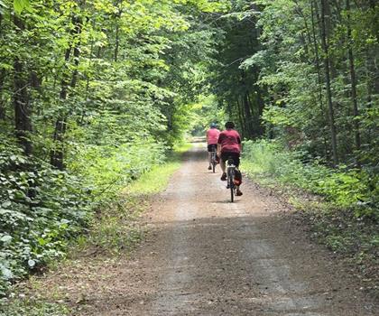
Oh no! We don't have any photos 😢

This trail hasn't been captured yet. Be the first to share your adventure!

Trail description

Description

Huron Park sits at the crossroads of four southwestern Ontario regions—Huron, Perth, Waterloo, and Wellington—offering hikers a diverse slice of the area's natural landscape. This 3.2-kilometer trail system winds through mixed terrain with 300 meters of elevation gain, making it a solid moderate hike that typically takes around 2.5 hours to complete at a comfortable pace.

Trail Experience

The trail network at Huron Park delivers variety that keeps things interesting from start to finish. You'll begin on well-maintained paths that lead through dense woodlands where towering trees create a natural canopy overhead—perfect for those hot summer days when shade becomes your best friend. The forest sections showcase the region's typical mixed hardwood composition, with maples, oaks, and birches dominating the canopy.

As you gain elevation, the trail opens into meadow areas that provide a completely different hiking experience. These clearings offer breathing room and natural rest spots where you can take in the surrounding landscape. The contrast between the enclosed forest sections and open meadows creates a rhythm to the hike that prevents monotony.

The park's water features add another dimension to the experience. Several ponds and streams are scattered throughout the trail system, creating peaceful spots that naturally invite longer breaks. These water sources also serve as wildlife magnets, increasing your chances of spotting local animals during your visit.

Wildlife and Seasonal Changes

Wildlife viewing opportunities are solid throughout the year, with deer being regular visitors that often allow hikers relatively close encounters before bounding away through the underbrush. The park's diverse habitat supports various bird species, making it particularly appealing for birdwatchers who want to combine their hobby with a good workout.

The changing seasons transform the park's character dramatically. Spring brings wildflowers to the meadow areas and fresh green growth throughout the forest. Summer offers full canopy coverage and the most comfortable hiking temperatures in the shaded sections. Fall delivers the classic Ontario color show as the hardwood trees put on their annual display. Winter hiking is possible, though the elevation changes can make some sections challenging in icy conditions.

Trail Difficulty and Terrain

The moderate difficulty rating reflects both the distance and the 300 meters of elevation gain spread throughout the route. The climbs aren't particularly steep or technical, but they're sustained enough to get your heart rate up and provide a genuine workout. Most of the elevation is gained gradually, though there are a few steeper sections that will have you breathing harder.

The trail surface varies from packed earth in the forest sections to grassier terrain in the meadows. Root systems from the larger trees create some natural obstacles that require attention, especially when the trail is wet. The path is generally wide enough for comfortable hiking, though some narrower sections through denser forest areas require single-file travel.

Beyond Hiking

While the hiking trails are the main attraction, Huron Park accommodates other outdoor activities that can extend your visit or provide alternatives for mixed groups. Cycling paths offer mountain bikers and casual riders another way to explore the area, though these routes follow different corridors than the hiking trails.

Designated picnic areas with tables and grills are strategically placed throughout the park, making it easy to plan a longer outing that combines hiking with outdoor dining. These facilities are particularly valuable for families or groups where not everyone wants to tackle the full trail distance.

The park's ponds provide quiet spots for reflection or photography, and the varied terrain offers numerous vantage points for capturing the landscape. Sunset photography can be particularly rewarding from the elevated meadow areas, where the open sky provides dramatic lighting opportunities.

Access and Facilities

Getting to Huron Park is straightforward from any of the major towns in the four-region area it serves. The central location makes it accessible for day trips from multiple directions, whether you're coming from Waterloo, Stratford, or smaller communities throughout the region.

Parking facilities are adequate for the park's typical usage levels, providing a hassle-free start to your outdoor adventure. The parking area connects directly to the main trail network, eliminating the need for road walking or complicated access routes.

Planning Your Visit

The 2.5-hour duration estimate assumes a moderate pace with time for breaks and wildlife observation. Stronger hikers can complete the route faster, while those who want to fully explore the various side paths and enjoy extended breaks at the scenic spots should plan for additional time.

Water and snacks are essential, particularly during warmer months when the elevation gain and 3.2-kilometer distance combine to create a genuine workout. Sunscreen becomes important in the meadow sections where tree cover disappears. The mixed terrain and seasonal variations make appropriate footwear crucial—sturdy hiking shoes or boots provide the best combination of support and traction.

Camera equipment is worth the extra weight, given the variety of photographic opportunities from forest scenes to open landscapes to wildlife encounters. The changing elevations and diverse habitats create multiple distinct environments within a single hike, each offering different visual appeal.

Ready to go?

Everything you need to know before you go

Where?

Address
Huron Park, ON N0M 1Y0, Canada
GPS coordinates
43.288881, -81.49448
Phone
Not available

Starting Point

The easiest way to get to the start of the trails at the huron park in Ontario is to drive there.

When?

Opening hours
From sunrise to sunset
Varies by season
Best season
Fall
Spectacular colors
Best time
Early morning
Less crowded
Weather (next days)
Loading

How much?

Entry fees
Adult
Not available
Child
What to bring?
Gear
  • Hiking shoes Essential
  • Layered clothing Essential
  • Rain jacket Essential
  • Trekking poles
  • Headlamp
Download the PDF checklist
Water & food
2L minimum
No water point on the trail
Bring energy snacks for a 4h+ hike
Good to know
Park rules
No dogs
Safety
Download the GPX before you go
Limited cellular coverage on the trail
Slippery after rain
Be careful on rocky sections
In an emergency
Emergency
911
Parking GPS
43.288881, -81.49448
Center
Not available

Hikers' opinions

0.0
5 Reviews
LB
Laura B.
Sep 12, 2023
Anstruther Lake is perfect for a quick escape into nature! We hiked in early fall, and the colorful foliage was stunning. The slight elevation changes made for a nice workout without being overwhelming. The tranquility of the lake surrounded by trees made it perfect for a light picnic afterwards. A truly rejuvenating experience!
MT
Michael T.
Aug 10, 2023
I visited Anstruther Lake for some early morning hiking in August. The mist rising off the lake was enchanting, and the sunrise over the water was breathtaking. The trail is relatively quiet, providing a great backdrop for nature photography. I managed to capture several shots of the local wildlife, including deer and various birds. Highly recommend for photographers!
SK
Sarah K.
Jul 20, 2023
While I enjoyed the lush greenery and tranquility at Anstruther Lake, I found the lack of amenities a bit disappointing. The trail could be more challenging for seasoned hikers, but it's great for a leisurely stroll. Make sure to bring plenty of water, as there are no facilities nearby. A nice escape, but go prepared!
DM
David M.
Jun 25, 2023
I took my parents to Anstruther Lake for a weekend hike, and we all appreciated the beautiful scenery and peaceful atmosphere. The trails are manageable for older adults, with lovely spots to rest and enjoy the surroundings. We saw a variety of birds, which was a bonus. The trailhead was easy to find, but be prepared for no free parking.
ER
Emily R.
May 15, 2023
The trails at Anstruther Lake are well-marked and offer a peaceful experience. We went hiking in late spring, and the wildflowers were in full bloom, adding a beautiful touch to our walk. Perfect for families, but expect some elevation changes. Not too strenuous for our young children, but they loved exploring the small streams along the way.

FAQ - Frequently asked questions

Everything you need to know
Easy
300.00
440.00
1h30
No
No
No, dogs are not permitted on the Anstruther Lake trails. This policy helps protect local wildlife and maintain the natural ecosystem of the area. Plan to leave your furry companions at home or find alternative dog-friendly trails in the region.
No, access to Anstruther Lake trails is not free and requires payment of fees. There are also parking fees in addition to the trail access costs. Check current pricing before your visit as fees may vary seasonally.
The trail information doesn't specify washroom facilities at the Anstruther Lake trailhead. It's recommended to use facilities in the town of Anstruther Lake before starting your hike. Plan accordingly as services may be limited along the trail itself.
With 150 meters of elevation gain, Anstruther Lake trail may be challenging for very young children depending on their hiking experience. The trail's difficulty level and duration should be considered when planning a family outing. Assess your children's fitness level and bring plenty of water and snacks.
The best time to hike Anstruther Lake trail is typically late spring through early fall when weather conditions are most favorable. Summer months offer the warmest temperatures and longest daylight hours for hiking. Winter hiking may be possible but requires proper gear and experience with cold weather conditions.
Didn't find your answer?
Free 1 pages

The Essential Hiking Checklist

Everything you need for your next hike. Bilingual, printable, 1 page.

Download the free checklist
Top 10 best hiking in Huron, Perth, Waterloo and Wellington
Our ranking based on hiker reviews

Hiking near Kitchener

142 trails to explore ~83 km away

View trails
Did you spot an error?

We work hard to provide the most up-to-date and error-free data possible. If something seems incorrect, let us know!

Update : June 2026