

Ready to explore Kissing Bridge Trailway? Here's everything you need to know before you go!
Discover the trail
Oh no! We don't have any photos 😢
This trail hasn't been captured yet. Be the first to share your adventure!Trail description
Description
The Kissing Bridge Trailway is one of southwestern Ontario's most rewarding rail-trail conversions, threading through four counties — Huron, Perth, Waterloo, and Wellington — along the former corridor of the Guelph and Goderich Railway. The result is a long-distance multi-use trail that connects rural communities, passes through working farmland and mature woodlands, and anchors itself to one of the region's most beloved heritage landmarks.
Trail Character and Terrain
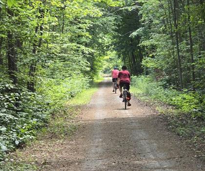
Because the trailway follows an old railway bed, the grades are remarkably gentle throughout. Railway engineers needed consistent, manageable slopes to move freight efficiently, and that legacy now benefits hikers, cyclists, and anyone who wants a long walk without punishing climbs. The surface — packed gravel and compacted dirt — holds up well across seasons and provides reliable footing for most users.
The landscape shifts constantly as you move along the corridor. Stretches of dense mixed woodland alternate with wide-open agricultural sections where fields of corn, soybeans, and pasture extend to distant tree lines. The open farmland sections feel expansive and quiet, while the forested segments offer shade, birdsong, and a more enclosed, intimate atmosphere. That rhythm of open and sheltered terrain is part of what makes the trailway interesting over longer distances.
Wildlife is a consistent presence. White-tailed deer are common along the field edges, particularly in the early morning and evening. Red-winged blackbirds are abundant wherever the trail borders wetland or open meadow, and several woodpecker species work the mature trees in the wooded sections. The mixed-habitat corridor — part forest edge, part agricultural land — supports a broader range of species than either environment would on its own.
The West Montrose Covered Bridge
The trail's most significant landmark is the West Montrose Covered Bridge, Ontario's last remaining covered bridge and the feature that gives the trailway its name. Built in 1881, this timber-frame structure spans the Grand River and has been designated a heritage site. Local tradition holds that courting couples would steal a kiss while passing through the covered interior, shielded from view — hence the nickname "Kissing Bridge" that eventually attached itself to the entire trailway.
Beyond the romantic history, the bridge is genuinely worth stopping to examine. The construction methods and materials reflect 19th-century engineering practices that have largely disappeared from the landscape, and the weathered timber has a texture and warmth that modern concrete structures simply don't offer. It's a tangible piece of rural Ontario history that most visitors find more compelling in person than in photographs.
Communities Along the Route
The trailway passes through or near several small towns and villages that developed around the original railway line. These communities offer natural stopping points with access to local shops, cafés, and parks. Many retain the character of their railway-era origins, and residents in these areas often have a genuine connection to the trail's history. If you're planning a longer outing, these towns provide opportunities to refuel, use washroom facilities, and take a break before continuing.
Several parks along the route include picnic tables, washrooms, and in some cases playground equipment, making them practical rest stops for families or anyone covering a longer section of trail.
Planning Your Hike
The trailway's full length of 45 kilometers means you have real flexibility in how you approach it. A short section of a few kilometers makes for a relaxed afternoon outing, while a full-day effort can cover 15 to 20 kilometers without the trail ever becoming technically demanding. The flat terrain shifts the challenge from elevation to distance and time rather than steepness.
Multiple access points are distributed along the route, so you can tailor your starting point to match your priorities — beginning near the West Montrose Covered Bridge if the heritage landmark is your main draw, starting from a larger community if you want amenities close at hand, or choosing a quieter rural access point if you prefer to be in open countryside from the first step.
The trail is designated for multiple uses, so expect to share the corridor with cyclists and occasionally horseback riders, especially on weekends. The wide path and generally good sightlines make this straightforward, but staying aware of other users keeps things smooth for everyone.
Seasonal Conditions
Spring brings wildflowers to the woodland sections and the fresh growth of emerging crops in the agricultural stretches. The trail's drainage — engineered for railway use — handles spring melt reasonably well, though muddy patches can develop after heavy rain or during the thaw period.
Summer fills in the canopy in forested sections, providing welcome shade, while the open farmland portions can get warm during midday. Fall is a strong season on this trail: the mixed hardwood forest produces solid autumn color, and the longer sightlines through thinning leaves open up views that are closed off in summer. Winter conditions can support snowshoeing when snow cover is adequate, and the bare trees reveal the structure of the landscape in a way that's worth experiencing on its own terms.
On the Trail
Stay on the designated corridor, particularly where the trail runs close to private agricultural land — property boundaries are often tight along the old railway right-of-way. Pack out everything you bring in, and give wildlife space, especially during nesting season in spring and early summer when disturbance has the most impact on local bird populations.
The Kissing Bridge Trailway rewards both the casual afternoon walker and the long-distance hiker looking to cover serious ground through the heart of southwestern Ontario's countryside.
Recommended gear for this trail


Ready to go?
Everything you need to know before you goStarting Point
The kissing bridge trailway is located in St. Catharines, Ontario. To get to the start of the trails, take Highway 406 to the Glendale Avenue exit. Turn left onto Glendale Avenue and then turn right onto Ridge Road. The trailhead will be on your left.
When?
How much?
- Hiking shoes Essential
- → Salomon Elixir Tour Mid WP · 203.38 $
- Layered clothing Essential
- Rain jacket Essential
- Trekking poles
- → Black Diamond Trail Ergo Cork · 69.99 $
- Headlamp
- → Petzl Actik Core 625 · 103.95 $
FAQ - Frequently asked questions
Everything you need to knowThe Essential Hiking Checklist
Everything you need for your next hike. Bilingual, printable, 1 page.
Download the free checklistSimilar hikes nearby
Discover other trails you might enjoy
Perth Harvest Pathway Milverton- G2G Rail Trail
Huron, Perth, Waterloo and Wellington

Health Valley Trail
Huron, Perth, Waterloo and Wellington
Mill Run Trail
Huron, Perth, Waterloo and Wellington
Waterloo Park
Huron, Perth, Waterloo and Wellington
Point Farms Provincial Park
Huron, Perth, Waterloo and Wellington
Breithaupt Park
Huron, Perth, Waterloo and Wellington
Hiking near Kitchener
142 trails to explore ~18 km away
We work hard to provide the most up-to-date and error-free data possible. If something seems incorrect, let us know! Your contribution helps the whole community.
Hikers' opinions