

Ready to explore Puslinch Lake? Here's everything you need to know before you go!
Discover the trail
Oh no! We don't have any photos 😢
This trail hasn't been captured yet. Be the first to share your adventure!Trail description
Description
Puslinch Lake sits quietly in southwestern Ontario, tucked within the Huron, Perth, Waterloo, and Wellington region. This remarkable body of water holds the distinction of being the largest kettle lake in North America — carved out thousands of years ago when retreating glaciers left behind a deep depression that gradually filled with exceptionally clear water. What makes this destination worth the trip isn't just its geological backstory, but the genuine sense of calm it offers within easy reach of Ontario's busier urban centers.
The lake spreads across a landscape of rolling hills and dense mixed woodland, creating a natural setting that feels surprisingly remote despite being a short drive from Kitchener-Waterloo and Guelph. On calm days, the water takes on an almost mirror-like quality, reflecting the surrounding canopy and open sky with real clarity. It's the kind of place that slows you down without asking you to.
Trail Network and Terrain
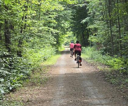
The hiking around Puslinch Lake works well for a broad range of abilities. The trail system makes good use of the natural topography, routing hikers through dense woodland where the canopy keeps things cool even on warm summer days. Elevation gain through the area runs around 30 meters — enough to give the terrain some character without turning into a workout.
The forest sections move between mature maple, oak, and pine, crossing small streams and opening occasionally into clearings where wildflowers appear in season. Underfoot, the surface shifts between soft pine duff, packed earth, and the occasional rocky stretch. Exposed root systems from the larger trees cross the path in places, so it pays to watch your footing, but nothing here would challenge a reasonably fit hiker.
For those who prefer flatter ground, the shoreline paths offer level walking with open views across the water. These routes let you take in the lake's impressive scale while staying close to the gentle sound of water against the natural shore. The contrast between the enclosed forest trails and the open lakeside walking gives you real options depending on what you're after on a given day.
The Kettle Lake Formation
The geology here is genuinely interesting and worth understanding before you arrive. Kettle lakes form when a large block of glacial ice gets buried under sediment, then slowly melts away, leaving a steep-sided depression. At Puslinch, that process created a lake with notably deep water relative to its surface area — the steep sides drop quickly from the shoreline, which contributes to the water's clarity and creates distinct microclimates as you walk the perimeter.
You'll notice the difference as you move between sections of trail. The areas close to the water tend to be cooler and more humid, supporting plant communities that differ noticeably from the drier conditions on higher ground away from the lake. That variation in habitat is part of what makes a full loop around the lake more interesting than a simple out-and-back.
Wildlife and Natural Features
The ecosystem around Puslinch Lake supports a solid variety of wildlife. White-tailed deer browse in the forest clearings, most reliably during early morning and evening. Red foxes are present in the area as well, though spotting one requires moving quietly and a bit of patience.
Birdwatching is a genuine draw here. Great blue herons work the shallow edges of the lake with their characteristic slow-motion patience, while the surrounding forest holds a good mix of woodland songbirds. The variety of habitats — open water, marshy shoreline edges, and mature forest — means you can encounter meaningfully different species within a relatively compact area. Waterfowl use the lake throughout the year, making it worth bringing binoculars regardless of the season.
Seasonal Conditions
Spring brings wildflower blooms to the forest floor and a noticeable uptick in bird activity as migratory species return. The trails can be soft and muddy during snowmelt, so waterproof footwear is worth having. That said, the fresh growth and active wildlife make spring one of the better times for observation.
Summer is the most comfortable season for hiking here. The forest canopy does real work keeping temperatures manageable, and the lake generates cooling breezes along the shoreline sections. It's also the season that lends itself best to combining a hike with time on the water — the calm surface is well-suited to kayaking or canoeing.
Fall is hard to beat at Puslinch Lake. The mixed forest turns through a full range of autumn colors, and the lake's reflective surface doubles the effect on still days. Cooler temperatures make for excellent hiking conditions, and the reduced leaf cover opens up sightlines through the forest that aren't available in summer.
Winter hiking is possible for those who come prepared. When the lake freezes and snow covers the trails, the landscape takes on a completely different character — quieter, starker, and worth experiencing if you have the right gear.
Getting There and Planning Your Visit
The location makes Puslinch Lake a practical day trip from the surrounding region. The drive from Kitchener-Waterloo or Guelph is short enough that you can head out for a morning hike and be home well before dinner — though the setting has a way of making you want to stay longer than planned.
The area works well for activities beyond hiking. The calm water is a natural fit for paddling, and the shoreline offers plenty of spots to stop for lunch. Bringing food to eat by the water is a simple way to extend the visit and make the most of the lake's atmosphere.
Staying on designated trails protects the surrounding ecosystem and keeps the area in good shape for everyone who comes after you — the relatively unspoiled character of Puslinch Lake depends on visitors treating it that way.
Recommended gear for this trail


Ready to go?
Everything you need to know before you goStarting Point
The start of the trails at the puslinch lake can be accessed by travelling east on Highway 6 from Guelph. The entrance to the park is located on the north side of the highway, just past the intersection with Wellington Road 34.
When?
How much?
- Hiking shoes Essential
- → Salomon Elixir Tour Mid WP · 203.38 $
- Layered clothing Essential
- Rain jacket Essential
- Trekking poles
- → Black Diamond Trail Ergo Cork · 69.99 $
- Headlamp
- → Petzl Actik Core 625 · 103.95 $
FAQ - Frequently asked questions
Everything you need to knowThe Essential Hiking Checklist
Everything you need for your next hike. Bilingual, printable, 1 page.
Download the free checklistSimilar hikes nearby
Discover other trails you might enjoy
Perth Harvest Pathway Milverton- G2G Rail Trail
Huron, Perth, Waterloo and Wellington

Mill Run Trail
Huron, Perth, Waterloo and Wellington
Health Valley Trail
Huron, Perth, Waterloo and Wellington
Waterloo Park
Huron, Perth, Waterloo and Wellington
Point Farms Provincial Park
Huron, Perth, Waterloo and Wellington
Breithaupt Park
Huron, Perth, Waterloo and Wellington
Hiking near Guelph
166 trails to explore ~14 km away
We work hard to provide the most up-to-date and error-free data possible. If something seems incorrect, let us know! Your contribution helps the whole community.
Hikers' opinions