

Ready to explore Royal Recreation Trail? Here's everything you need to know before you go!
Discover the trail
Oh no! We don't have any photos 😢
This trail hasn't been captured yet. Be the first to share your adventure!Trail description
Description
The Royal Recreation Trail is a pleasant, easy-going route in the Huron, Perth, Waterloo, and Wellington region of Ontario. The trail system comprises multiple sections totaling 5.5 km, with individual segments ranging from 2 to 4.5 km depending on your starting point. The surface consists of well-packed earth paths and crushed gravel sections that are welcoming underfoot without requiring anything beyond standard walking shoes. Minimal elevation change means the trail never pushes you, making it a solid pick for families with younger kids, older hikers, or anyone who just wants a relaxed time outside.
Trail Experience and Terrain
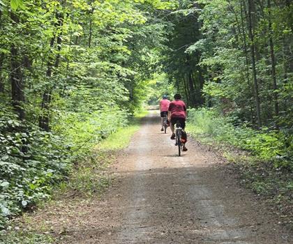
The Royal Recreation Trail is a multi-use path (2.5 metres wide) that meanders through parks, school sites and open spaces, particularly within and around Guelph. The route moves through a mix of environments that keeps the trail from feeling repetitive. You'll pass through sections of mature forest where the tree canopy closes in overhead, then out into open stretches with wider views of the surrounding agricultural landscape. The trail also runs alongside waterways (Speed River and Eramosa River in sections), which naturally become the spots where people slow down, take a break, and listen to the water.
The trail is excellent for walking, cycling and cross-country skiing. Limited areas are wheelchair accessible. The alternating terrain—forest, open field, waterside—is one of the trail's better qualities. Each section has a different feel, and the transitions happen naturally rather than abruptly. The forested parts offer shade and a quieter atmosphere, while the open sections give you a sense of the broader countryside that defines this part of Ontario.
Wildlife and Natural Features
The habitat variety along the trail supports a decent range of wildlife. Deer are a common sight in the open field sections, especially if you're out early in the morning or in the late afternoon. The mixed forest stretches are worth slowing down for if you're into birds—the combination of tree cover and nearby water creates good conditions for spotting local species.
The waterways along the route add their own layer of interest. Aquatic birds show up regularly, and the vegetation along the banks tends to be denser and more varied than elsewhere on the trail. These spots also tend to be cooler in summer, which is a practical bonus on warmer days when the open sections offer limited shade.
Seasonally, the trail changes character noticeably. Spring brings wildflowers along the forest floor and field edges. By autumn, the deciduous trees along the route put on a solid colour display. Winter use is possible depending on conditions, though the open sections will be more exposed to wind.
Access and Trailheads
The trail has multiple access points across Huron, Perth, Waterloo, and Wellington counties, with designated trailheads that include parking. This setup gives you flexibility—you can hike segments based on your time or interests. The trail system meanders through the City of Guelph area and surrounding regions, making it easily accessible from local communities. Basic services are readily available nearby.
Planning Your Visit
The trail's mix of shaded and open sections means layering makes sense regardless of season. Waterproof footwear is worth considering, particularly near the waterway sections where the ground can stay soft longer, especially in spring or after rain.
Bring water, especially in summer. The open field portions don't offer much shade. Binoculars are worth tossing in a bag if bird-watching is on your agenda. As with any trail, sticking to the marked path and packing out what you bring in keeps the area in good shape for everyone.
Recommended gear for this trail


Ready to go?
Everything you need to know before you goStarting Point
The royal recreation trail is located in Ontario, Canada. To get to the start of the trails, take Highway 401 to exit 431 and head north on County Road 2. The trailhead will be on your left.
When?
How much?
- Hiking shoes Essential
- → Salomon Elixir Tour Mid WP · 203.38 $
- Layered clothing Essential
- Rain jacket Essential
- Trekking poles
- → Black Diamond Trail Ergo Cork · 69.99 $
- Headlamp
- → Petzl Actik Core 625 · 103.95 $
FAQ - Frequently asked questions
Everything you need to knowThe Essential Hiking Checklist
Everything you need for your next hike. Bilingual, printable, 1 page.
Download the free checklistSimilar hikes nearby
Discover other trails you might enjoy
Perth Harvest Pathway Milverton- G2G Rail Trail
Huron, Perth, Waterloo and Wellington

Mill Run Trail
Huron, Perth, Waterloo and Wellington
Health Valley Trail
Huron, Perth, Waterloo and Wellington
Waterloo Park
Huron, Perth, Waterloo and Wellington
Point Farms Provincial Park
Huron, Perth, Waterloo and Wellington
Conestogo Lake
Huron, Perth, Waterloo and Wellington
Hiking near Guelph
166 trails to explore ~1 km away
We work hard to provide the most up-to-date and error-free data possible. If something seems incorrect, let us know! Your contribution helps the whole community.
Hikers' opinions