

Ready to explore Walter Bean Grand River Trail? Here's everything you need to know before you go!
Discover the trail
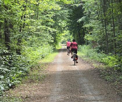
Oh no! We don't have any photos 😢
This trail hasn't been captured yet. Be the first to share your adventure!Trail description
Description
The Walter Bean Grand River Trail is a 76-kilometer route that winds through the regions of Huron, Perth, Waterloo, and Wellington in Ontario, following the Grand River through some of the most varied countryside in the area. It's a trail that rewards you differently depending on where you start and how far you go — the landscape shifts enough along its length that two hikes on different sections can feel like entirely separate experiences.
The Grand River is the constant thread running through the whole route. You're rarely far from the water, and that proximity shapes everything — the sounds, the wildlife, the light filtering through riverside vegetation. The trail moves between open riverbank stretches, mixed hardwood forest, wetland boardwalks, and meadow sections, with gentle rolling hills providing enough elevation change to keep things interesting without turning into a slog. The total elevation gain sits around 200 meters across the full length, which gives you a sense of how gradual the terrain really is.
Trail Surface and Navigation
The surface changes as you move through different sections. Packed dirt paths make up most of the forested stretches, with boardwalk sections crossing over wetland areas and occasional paved segments near urban access points. The trail is consistently well-marked throughout, so route-finding isn't a concern even if you're visiting for the first time. Signage is clear at junctions, and the overall layout is straightforward to follow.
Given the 76-kilometer total distance, most people tackle this trail in sections rather than attempting it end-to-end. The estimated time of 3 hours 30 minutes reflects a solid section hike rather than the full route in one go. The multiple access points along the way make it easy to plan hikes of different lengths depending on what you're after.
Access Points and How to Use Them
One of the practical strengths of this trail is the number of entry points spread along its length. Parking areas are positioned at regular intervals, which opens up a lot of flexibility. You can run a straightforward out-and-back from whichever access point suits your schedule, or arrange a car shuttle with a second vehicle to do a one-way section. Some starting points drop you into more urban surroundings before the trail transitions into natural areas, while others put you directly into forest or riverside terrain from the first steps.
This structure makes the Walter Bean Grand River Trail work well for a wide range of hikers — someone with a couple of hours can pick a shorter section, while those planning a longer day can string together multiple segments. The trail doesn't demand a specific commitment level, which is part of why it gets used regularly by locals and visitors alike.
Wildlife and Natural Features
The mix of habitats along the route — river, forest, meadow, and wetland — supports a solid variety of wildlife. White-tailed deer are a common sight in the meadow sections, particularly in early morning and evening. The Grand River draws great blue herons, kingfishers, and various duck species, and patient hikers in quieter stretches sometimes spot beavers or river otters. The forest sections are productive for birdwatching, with cardinals, woodpeckers, and seasonal warblers moving through during migration periods.
Spring brings wildflowers along the riverbanks and forest floor, and the snowmelt pushes the river higher, making for more dramatic water views. Summer fills in the hardwood canopy — maple, oak, and birch — providing good shade on hot days, though humidity near the river can build in July and August. Fall is when the trail really stands out visually, with the hardwood forest turning through reds, oranges, and yellows overhead. Winter hiking is possible on many sections, though ice near the riverbank requires attention.
Historical Context
The trail is named for Walter Bean, a community figure whose work focused on preserving natural spaces and making them accessible to the public. His influence shaped how the region approached trail development and conservation, and that legacy is reflected in the quality and continuity of the route today.
Interpretive plaques at various points along the trail add context to what you're walking through — covering Indigenous history in the region, the Grand River's role in early European settlement, and the industrial and agricultural development that followed. The Grand River has been a central feature of this landscape for centuries, used for transportation, power, and sustenance long before the trail existed. Walking the riverbank, you're covering ground that has seen a lot of different chapters of Ontario's history.
Photography Opportunities
The trail offers a range of photographic conditions depending on where you are and what time of day you're out. River bend viewpoints give you classic water-and-forest compositions, while the elevated sections open up broader views across the Grand River valley. Early morning and late afternoon light work particularly well along the water. The wetland boardwalk sections and the fall hardwood canopy are two of the more visually distinctive features worth planning around if photography is part of your reason for being out there.
Surrounding Area
The trail passes through four regions, and the surrounding communities add to the overall experience if you're making a day of it. Small towns in the area offer local restaurants and cafes that work well for post-hike stops. Several conservation areas are also within easy reach of various access points, which makes the Walter Bean Grand River Trail a natural anchor for a longer outdoor weekend in the Grand River watershed.
Recommended gear for this trail


Ready to go?
Everything you need to know before you goStarting Point
The walter bean grand river trail is located in Kitchener, Ontario. To get to the start of the trails, take Highway 7/8 to Homer Watson Boulevard. Turn onto Homer Watson Boulevard and continue until you reach the walter bean grand river trail.
When?
How much?
- Hiking shoes Essential
- → Salomon Elixir Tour Mid WP · 203.38 $
- Layered clothing Essential
- Rain jacket Essential
- Trekking poles
- → Black Diamond Trail Ergo Cork · 69.99 $
- Headlamp
- → Petzl Actik Core 625 · 103.95 $
FAQ - Frequently asked questions
Everything you need to knowThe Essential Hiking Checklist
Everything you need for your next hike. Bilingual, printable, 1 page.
Download the free checklistSimilar hikes nearby
Discover other trails you might enjoy
Perth Harvest Pathway Milverton- G2G Rail Trail
Huron, Perth, Waterloo and Wellington

Health Valley Trail
Huron, Perth, Waterloo and Wellington
Mill Run Trail
Huron, Perth, Waterloo and Wellington
Waterloo Park
Huron, Perth, Waterloo and Wellington
Point Farms Provincial Park
Huron, Perth, Waterloo and Wellington
Breithaupt Park
Huron, Perth, Waterloo and Wellington
Hiking near Kitchener
142 trails to explore ~7 km away
We work hard to provide the most up-to-date and error-free data possible. If something seems incorrect, let us know! Your contribution helps the whole community.
Hikers' opinions