

Ready to explore Ganaraska Forest Trail? Here's everything you need to know before you go!
Discover the trail


Trail description
Description
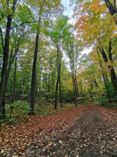
The Ganaraska Forest Trail cuts through one of Southern Ontario's most impressive natural landscapes — 11,000 acres of mixed forest that manages to feel genuinely remote despite sitting within reach of the Greater Toronto Area. This isn't a manicured park trail. It's a working forest with real terrain, real wildlife, and the kind of quiet that's getting harder to find in this part of the province.
The trail covered here runs 15 kilometers with 150 meters of elevation gain, making it a solid moderate hike that most reasonably fit hikers can complete in around four and a quarter hours. It's long enough to feel like a real day out, but not so demanding that you need to be a seasoned backcountry hiker to enjoy it.
What the Terrain Actually Feels Like
The Ganaraska Forest Trail moves through several distinct environments as you hike, and that variety is a big part of what makes it worth the drive. You'll spend stretches under dense hardwood canopy — maple and oak mostly — where the light filters down in a way that makes the forest feel almost cathedral-like. Then the trail opens into meadow sections before pushing back into coniferous stands where the ground stays soft and springy underfoot.
Some sections follow old logging roads, which means wider paths and easier footing. Others narrow down to true single-track that winds between trees and crosses small creek drainages. The elevation changes are gradual rather than dramatic — 150 meters over 15 kilometers won't leave you gasping — but there are climbs that will get your legs working, and the high points open up views across the forest canopy that make the effort worthwhile.
Footwear matters here. Sections of the trail cross rocky ground and muddy patches, especially near the creek crossings, so hiking boots with decent ankle support will serve you better than trail runners on most days.
Seasonal Conditions
Spring is when the forest floor comes alive before the canopy closes in. Trilliums and wild leeks spread across the ground in patches, and bird activity peaks as migrants move through. The trade-off is mud — snowmelt and spring rains can make some sections genuinely wet, so check conditions before you go.
Summer hiking here benefits from the full canopy cover, which keeps temperatures noticeably cooler than open trails on hot days. The denser, wetter sections of the forest can have mosquitoes and blackflies, so bring repellent if you're hiking between late May and July.
Fall is the season most people remember. The mixed hardwood and conifer composition creates a wide range of colors — it's one of the better fall foliage hikes in the region, and the cooler temperatures make for comfortable hiking conditions. Winter keeps the trails accessible for snowshoeing when there's enough snow on the ground, and the bare trees open up sight lines you don't get in other seasons.
Wildlife
The forest's size creates habitat for species that have been squeezed out of smaller woodlots across Southern Ontario. White-tailed deer are common, particularly in the meadow sections during early morning and evening. Red foxes and coyotes move through regularly. Black bears are present in the forest, though encounters are uncommon and typically brief.
Birding is a genuine draw here. Over 200 species have been recorded in the Ganaraska Forest, supported by the mix of habitats the trail passes through. Pileated woodpeckers work the older hardwood sections. Warblers move through in numbers during migration. The open meadow areas attract bobolinks and eastern bluebirds. Hawks and other raptors are frequently visible above the canopy, and the wetland and stream areas bring in waterfowl and wading birds.
The creek crossings and small wetlands scattered along the route are worth slowing down for — they're consistently the best spots for wildlife activity, and they make natural rest stops on longer stretches.
Planning Your Hike
The Ganaraska Forest Centre is your best resource for current trail conditions and any updates before you head out. Weather affects this trail significantly — heavy rain can turn creek crossings into real obstacles, and spring snowmelt adds time and mud to any route. A quick check before you leave saves headaches on the trail.
There are no facilities once you're on the trail, so carry enough water and food for the full distance. Four-plus hours in the forest goes faster than you'd think when you're stopping for wildlife or photography, but it also means you want to be self-sufficient from the start.
The forest has multiple access points, each connecting to different sections of the broader 159-kilometer network. The trailhead you choose will shape your experience — some entrances put you immediately into longer wilderness routes, while others are better suited for shorter loops or specific features like viewpoints and wildlife areas. Checking the trail map at the entry point before you set off is worth the few minutes it takes.
- Distance: 15 km
- Elevation gain: 150 m
- Difficulty: Moderate
- Estimated time: 4 hours 15 minutes
- Footwear: Hiking boots recommended
- Facilities on trail: None — carry water and food
- Trail info: Ganaraska Forest Centre
The Ganaraska Forest Trail delivers a legitimate wilderness feel within a reasonable drive of Southern Ontario's urban centres, and the 15-kilometer route gives you enough distance to really settle into the forest before you have to turn around.
Services and amenities
This information may vary by season.
Recommended gear for this trail


Ready to go?
Everything you need to know before you goStarting Point
The Ganarsaka trail begins at Port Hope on Lake Ontario's north coast and connects with the Bruce Trail in Glen Huron after more than 400 kilometres.
The Ganaraska trail links with the Lake Ontario Waterfront Trail in Port Hope. The path crosses the Oak Ridges (hiking) Trail in the Ganaraska Forest.
A branch route veers off to Midland in the hills of Oro Township, between Barri and Orillia, and then swings south, via Wasaga Beach, to rejoin the main trail about east of Glen Huron (the link between the Midland section and the Wasaga section is not yet complete).
The trail's entire length exceeds 500 kilometres, including numerous offshoot paths.
When?
How much?
- Hiking shoes Essential
- → Salomon Elixir Tour Mid WP · 203.38 $
- Layered clothing Essential
- Rain jacket Essential
- Trekking poles
- → Black Diamond Trail Ergo Cork · 69.99 $
- Headlamp
- → Petzl Actik Core 625 · 103.95 $
FAQ - Frequently asked questions
Everything you need to knowThe Essential Hiking Checklist
Everything you need for your next hike. Bilingual, printable, 1 page.
Download the free checklistSimilar hikes nearby
Discover other trails you might enjoy

Victoria Rail Trail
Kawarthas Northumberland
Chandos Lake
Kawarthas Northumberland
Petroglyphs Provincial Park
Kawarthas Northumberland
Presqu'ile Provincial Park
Kawarthas Northumberland
Ranney Gorge Suspension Bridge
Kawarthas Northumberland
Head Lake
Kawarthas Northumberland
Hiking near Toronto
168 trails to explore ~77 km away
We work hard to provide the most up-to-date and error-free data possible. If something seems incorrect, let us know! Your contribution helps the whole community.
Hikers' opinions