

Ready to explore Kawartha Highlands Provincial Park? Here's everything you need to know before you go!
Discover the trail
Trail description
Description
Kawartha Highlands Provincial Park covers 375 square kilometers of Canadian Shield wilderness in Kawarthas Northumberland, making it the second-largest provincial park in Southern Ontario. It's the kind of place where you can genuinely lose yourself in the landscape — granite domes, dense mixed forest, beaver ponds, and lakes stretching in every direction. Whether you're out for a short day hike or planning a multi-day backcountry trip, the park delivers a level of wildness that's hard to find this close to populated southern Ontario.
The Landscape
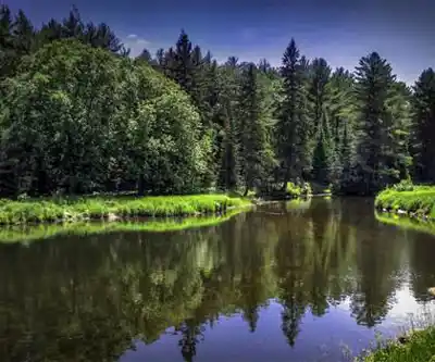
The Canadian Shield sets the tone for everything here. Ancient granite outcrops push up through the forest floor, creating natural viewpoints and open rocky sections that break up the tree cover. Mixed forest of maple, birch, and pine fills the spaces between, and the understory shifts constantly as you move through the terrain. Wetlands and beaver ponds are woven throughout, adding a layer of complexity to the ecosystem and giving the park a mosaic quality — you're rarely in the same type of habitat for long.
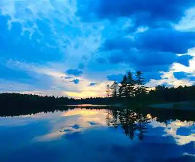
The interconnected lake system is one of the park's defining features. Water is everywhere, and the relationship between forest, wetland, and open water shapes both the wildlife and the hiking experience. Many trails bring you to shorelines where you can watch the transition from dense boreal canopy down to the water's edge.
Hiking the Park
The trail network here works for a wide range of hikers. The well-maintained paths are clearly signed throughout, so navigation stays manageable even if you're new to the area. The terrain alternates between smooth granite slabs, rooted forest floor covered in pine needles and fallen leaves, and occasional stream crossings that add some variety to the rhythm of the walk.
The Anstruther Lake Trail is one of the standout day hike options in the park. It moves through classic Canadian Shield scenery — granite outcrops, mixed forest, and eventually the open water of Anstruther Lake itself. It's a moderate route that gives you a solid feel for the park's character without demanding a lot of technical skill. The payoff at the lake is worth the effort.
For the specific trail featured here, the numbers are straightforward: 3.2 km with 150 m of elevation gain, rated Easy, and typically completed in around 1 hour. The elevation is gentle enough that most hikers won't feel pushed, but the Canadian Shield terrain means you'll still want proper footwear — granite can get slippery when wet, and the uneven rock surfaces reward boots with solid ankle support and grip.
Wildlife
The park's mix of habitats makes for good wildlife watching. White-tailed deer show up regularly along the trails, especially in the early morning and around dusk. Beaver activity is visible throughout — their dams and lodges are easy to spot near the wetland sections, and the ponds they've created have become important habitat for a range of other species. Moose are present in the park, particularly near wetland areas where they come to feed.
Birdlife is strong here. Loons are a constant presence on the lakes, and their calls carry across the water in a way that's become synonymous with the Canadian Shield experience. Woodpeckers work the mature trees along the trails, and raptors — hawks and eagles — use the thermals rising off the warm granite to gain altitude and scan the landscape below.
Paddling and Water Access
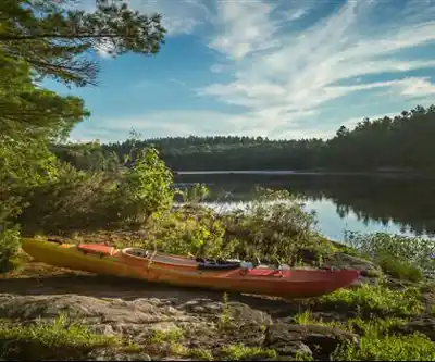
Hiking is the main draw for most visitors, but the park's water network opens up a second dimension to the experience. The interconnected lakes and rivers are well-suited to canoeing and kayaking, with routes ranging from short afternoon paddles to multi-day expeditions. From the water, the scale of the granite formations reads differently than it does from the trail — you get a broader view and access to remote shorelines and hidden bays that you'd never reach on foot.
The waterways follow routes that have been traveled for centuries, and the landscape along them has changed very little. It's a different pace than hiking, but the same core experience: moving through a landscape that feels genuinely wild.
Backcountry Camping
The park has backcountry campsites scattered throughout its 375 square kilometers, positioned to take advantage of natural features — elevated granite platforms, sheltered bays, spots with open views across the water. Camping here feels remote in a way that's hard to manufacture. The sites provide the basics you need without softening the experience too much, and waking up to loons calling across a misty lake is about as Canadian Shield as it gets.
What to Bring
Cell coverage is unreliable across much of the park, so plan accordingly. Bring a map, let someone know your route, and carry more water than you think you'll need — the granite terrain can be more demanding than the trail ratings suggest on a warm day. A basic first aid kit is worth the weight, and layered clothing makes sense in any season given how quickly conditions can shift in this part of Ontario. Rain gear is a smart addition regardless of the forecast, and if you're heading out on the granite sections, boots with real traction will make a noticeable difference in both safety and comfort.
The park's size works in your favor when it comes to crowds — even on busy weekends, the trail network spreads people out enough that you're unlikely to feel like you're sharing the wilderness with too many others.
Recommended gear for this trail


Ready to go?
Everything you need to know before you goStarting Point
The kawartha highlands provincial park is located in Ontario. To get to the start of the trails, take Highway 28 east from Peterborough. The park is located about 25 kilometers from Peterborough.
When?
How much?
- Hiking shoes Essential
- → Salomon Elixir Tour Mid WP · 203.38 $
- Layered clothing Essential
- Rain jacket Essential
- Trekking poles
- → Black Diamond Trail Ergo Cork · 69.99 $
- Headlamp
- → Petzl Actik Core 625 · 103.95 $
FAQ - Frequently asked questions
Everything you need to knowThe Essential Hiking Checklist
Everything you need for your next hike. Bilingual, printable, 1 page.
Download the free checklistSimilar hikes nearby
Discover other trails you might enjoy

Victoria Rail Trail
Kawarthas Northumberland
Chandos Lake
Kawarthas Northumberland
Petroglyphs Provincial Park
Kawarthas Northumberland
Presqu'ile Provincial Park
Kawarthas Northumberland
Ranney Gorge Suspension Bridge
Kawarthas Northumberland
Head Lake
Kawarthas Northumberland
Hiking near Barrie
146 trails to explore ~123 km away
We work hard to provide the most up-to-date and error-free data possible. If something seems incorrect, let us know! Your contribution helps the whole community.
Hikers' opinions