

Ready to explore Parc National Kuururjuaq? Here's everything you need to know before you go!
Discover the trail
Trail description
Description
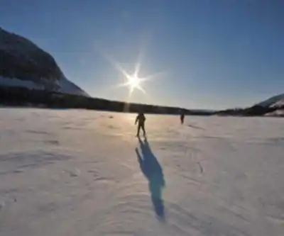
Parc national Kuururjuaq represents Quebec's most remote wilderness experience, sprawling across 4,460 square kilometers of untouched northern landscape in the Nunavik region. This isn't a park where you follow marked trails to scenic lookouts—it's a place where you travel through vast terrain under the shadow of the Torngat Mountains, some of the highest peaks east of the Rockies. The hiking here feels more like expedition travel than a typical park visit, demanding self-reliance while delivering an authentically wild northern experience that's increasingly rare to find.
The scale of Kuururjuaq changes how you approach outdoor time. Instead of planning around specific trail distances or summit objectives, you're working within a massive northern environment where weather, terrain, and your own energy levels shape each day's possibilities. The park's extreme remoteness means you'll experience true disconnection from the usual noise and infrastructure of more accessible hiking areas, creating space for the kind of immersive wilderness travel that defines the best of Nord-du-Québec's backcountry.
Hiking the Koroc River Valley
The Koroc River Valley serves as the park's primary hiking destination, offering a range of terrain that accommodates different experience levels and trip goals. The valley's long sightlines and constantly shifting perspectives create the kind of picturesque setting that makes every kilometer feel worthwhile, whether you're moving at a leisurely pace or pushing through more challenging sections.
For hikers seeking gentler terrain, the valley provides options that emphasize scenery over physical challenge. These routes let you settle into a comfortable rhythm while taking in the dramatic backdrop of surrounding peaks and the river's meandering course through the landscape. The terrain here allows for steady progress without demanding technical skills, making it possible to focus on the experience of moving through such a pristine northern environment.
More experienced hikers will find plenty of rugged terrain that demands careful route-finding and solid backcountry skills. These challenging sections reward the extra effort with an even stronger sense of expedition-style travel, where every gain in elevation or distance covered feels genuinely earned. The combination of rough footing, variable conditions, and the Torngat Mountains' imposing presence creates hiking that matches the dramatic scale of the setting.
What sets the Koroc River Valley apart from more developed hiking areas is the complete absence of built infrastructure. You won't find boardwalks, interpretive signs, or maintained trail markers. Instead, you're navigating through unmodified landscape where reading terrain and making smart route choices becomes part of the skill set needed for a successful day out.
Terrain and trail conditions
The hiking terrain in Kuururjuaq varies significantly depending on your chosen route and how far you venture from the valley floor. Gentler sections typically follow natural corridors where the ground is more stable and the grade remains manageable, allowing hikers to cover distance while staying comfortable. These areas work well for groups with mixed experience levels or anyone wanting to prioritize scenery and wildlife watching over physical challenge.
The more demanding terrain lives up to the park's reputation for rugged backcountry travel. Expect uneven ground, loose rock, and sections where route-finding skills matter more than following an obvious path. This type of hiking requires good boots, careful attention to footing, and the flexibility to adjust your pace based on conditions. The payoff comes in the form of access to more remote areas and the satisfaction that comes with genuine wilderness travel.
Weather can dramatically affect trail conditions throughout the hiking season. The northern location means temperatures can shift quickly, and precipitation can make already challenging terrain significantly more difficult. Smart hikers build extra time into their plans and carry gear appropriate for changing conditions, treating weather variability as part of the authentic northern wilderness experience rather than an inconvenience.
Wildlife and natural features
The park's pristine habitat supports populations of caribou, black bears, and diverse bird species that add an element of wildlife watching to any hiking trip. Caribou sightings can be particularly memorable, as these animals embody the wild character of the northern landscape. Bear encounters, while less common, serve as important reminders that you're traveling through active wildlife habitat where staying alert and following proper food storage practices are essential.
Bird watching opportunities abound throughout the hiking season, with species adapted to the northern environment providing constant entertainment for observant hikers. The variety of habitats within the park—from river corridors to alpine areas—supports different bird communities, making it worthwhile to carry binoculars and take time for wildlife observation during rest breaks.
The presence of the Torngat Mountains dominates the visual landscape throughout most hiking areas in the park. These peaks provide constant reference points for navigation while creating the kind of dramatic backdrop that makes every photo look like a postcard. Even when you're not climbing the mountains themselves, their presence adds a sense of scale and grandeur that elevates the entire hiking experience.
Multi-activity opportunities
Kuururjuaq's extensive water features make it possible to combine hiking with canoeing and kayaking for travelers interested in experiencing the park from multiple perspectives. The pristine rivers and lakes offer paddling routes that complement hiking itineraries, providing access to different areas of the park while giving legs a rest from trail travel.
The park's remote location and absence of light pollution create exceptional stargazing conditions that shouldn't be overlooked when planning multi-day trips. Clear northern nights can deliver spectacular sky viewing that rivals any planetarium, making it worth building evening astronomy time into your itinerary rather than treating dark skies as an incidental bonus.
Planning for remote wilderness travel
The park's limited facilities require hikers to arrive completely self-sufficient for their planned time in the backcountry. This means carrying all necessary food, water treatment, shelter, and safety equipment without relying on resupply options or emergency services that might be available in more developed parks. The remoteness that makes Kuururjuaq special also demands a higher level of preparation and self-reliance.
Communication and emergency planning take on added importance given the park's isolation. Cell service is non-existent, and help is far away if things go wrong. Successful trips require conservative planning, appropriate gear for changing conditions, and the skills needed to handle problems independently. This level of self-sufficiency is part of what makes the experience so rewarding for hikers seeking authentic wilderness travel.
The park's pristine environment and lack of development create hiking experiences that feel genuinely wild and unfiltered, with the Koroc River Valley and surrounding Torngat Mountains providing a setting that's unmatched elsewhere in Nord-du-Québec. Whether you choose gentler valley routes or commit to more challenging backcountry travel, success depends on matching your plans to the reality of remote northern wilderness while bringing the equipment and mindset needed to be comfortable in this spectacular but demanding environment.
Recommended gear for this trail


Ready to go?
Everything you need to know before you goStarting Point
To access the hiking trails, you can start at the main trailhead located near the park's entrance. The primary access point is through the village of Kangiqsualujjuaq. From there, you can reach the park by traveling along local roads that lead to designated parking areas and trailheads. Note that due to the remote location, it is advisable to check for any specific transportation arrangements or guided tours that may be available to facilitate access to the trails.
When?
Tuesday: 9:00 AM – 5:00 PM
Wednesday: 9:00 AM – 5:00 PM
Thursday: 9:00 AM – 5:00 PM
Friday: 9:00 AM – 5:00 PM
Saturday: 12:00 – 8:00 PM
Sunday: 12:00 – 8:00 PM
How much?
- Hiking shoes Essential
- → Salomon Elixir Tour Mid WP · 203.38 $
- Layered clothing Essential
- Rain jacket Essential
- Trekking poles
- → Black Diamond Trail Ergo Cork · 69.99 $
- Headlamp
- → Petzl Actik Core 625 · 103.95 $
FAQ - Frequently asked questions
Everything you need to knowTuesday: 9:00 AM – 5:00 PM
Wednesday: 9:00 AM – 5:00 PM
Thursday: 9:00 AM – 5:00 PM
Friday: 9:00 AM – 5:00 PM
Saturday: 12:00 – 8:00 PM
Sunday: 12:00 – 8:00 PM
The Essential Hiking Checklist
Everything you need for your next hike. Bilingual, printable, 1 page.
Download the free checklistHiking near Charlottetown
11 trails to explore ~1385 km away
We work hard to provide the most up-to-date and error-free data possible. If something seems incorrect, let us know! Your contribution helps the whole community.
Hikers' opinions