

Ready to explore Sentier Cathare? Here's everything you need to know before you go!
Discover the trail
Trail description
The Sentier Cathare is one of southern France's most compelling long-distance trails, stretching 253 kilometers through the Aude department in the heart of Occitanie. It follows ancient paths that once connected medieval Cathar strongholds across the Languedoc, weaving together rugged natural landscapes and a history that still feels very much alive underfoot. This is not a casual weekend outing — rated Hard and typically completed in 12 to 15 days, it demands genuine commitment and solid preparation.
The trail takes its name from the Cathars, a religious movement that flourished in this region during the 12th and 13th centuries before being violently suppressed during the Albigensian Crusade. Walking these paths, you move through the aftermath of that history at every turn — castle ruins crowning rocky ridgelines, villages that once sheltered refugees, landscapes that feel simultaneously peaceful and haunted. The route connects several of the most significant Cathar sites in the region, giving the journey a narrative thread that most long trails simply don't have.
Terrain and Trail Experience
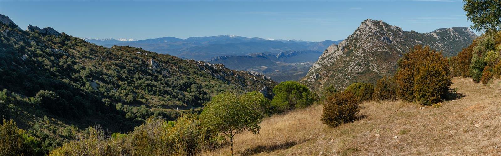
The Sentier Cathare crosses some of the most varied terrain in the French Pyrenees foothills, and that variety is a big part of what makes it worth the effort. You'll move through aromatic garrigue scrubland thick with wild thyme, rosemary, and lavender, then climb into sections of oak and beech forest that offer real shade and, in October and November, spectacular autumn color. The trail also passes through the Corbières massif, a landscape defined by limestone formations, deep gorges, and a distinctly Mediterranean character.
Expect the full range of trail conditions. Some sections follow gentle vineyard paths where the walking is easy and the views are wide. Others demand careful footwork on steep, loose scree slopes or scrambling over rocky outcrops. Many segments trace ancient mule tracks carved into cliffsides, with long drops on one side and sweeping views across the Aude valley on the other. On clear days, the snow-capped Pyrenees are visible in the distance — a reminder of how far south you've come.
The limestone bedrock is worth noting specifically: it creates interesting geological features throughout the route, but it becomes genuinely slippery when wet. Proper hiking boots with solid grip are not optional here. Exposed ridgelines are also common, and the mistral wind can be fierce, particularly during winter and spring. This is a trail that rewards experience and punishes complacency.
Historical Highlights Along the Route
The castles are the heart of this trail, and they deliver. The Sentier Cathare connects more than a dozen fortress ruins, each occupying a dramatic position and carrying its own story. A few stand out as genuinely unmissable:
- Peyrepertuse — Often called the "Carcassonne of the sky," this fortress sits on a clifftop at a height that makes it feel almost unreachable. The scale of the ruins and the views from the walls are extraordinary.
- Quéribus — The last Cathar stronghold to fall, in 1255. Its isolated tower on a narrow ridge is one of the most striking silhouettes on the entire route.
It's worth knowing that these fortifications were largely built after the Cathar period, constructed by the French crown to defend its newly acquired southern border. They're called "châteaux cathares" by association with the region and the era, not because the Cathars built them. That distinction doesn't diminish the experience — if anything, it adds a layer of complexity to the history you're walking through.
Wildlife and Natural Environment
The ecosystems along the Sentier Cathare are genuinely diverse, and the wildlife reflects that. In the forested sections, wild boar tracks are a common sight in muddy ground, though the animals themselves tend to stay out of sight during daylight hours. The open garrigue is excellent bird habitat — bee-eaters, hoopoes, and various raptors are regularly spotted, riding thermals above the sun-baked limestone.
The botanical richness of the Corbières is well documented, with over 2,000 plant species recorded in the area. Spring brings wildflower displays that include numerous orchid species thriving in the alkaline soils. Several sections of the trail pass through areas designated as important botanical sites, where rare Mediterranean plants reach the northern edge of their range.
On warm, sunny days, keep an eye on the rocks — various lizard species, including the large psammodromus and the wall gecko, are often seen basking in exposed spots. Snake encounters are possible but uncommon, and most species in the area pose no risk to hikers.
Seasonal Considerations
The Mediterranean climate of the Aude makes the Sentier Cathare walkable across most of the year, but the experience varies significantly by season. Spring and autumn are the sweet spots: mild temperatures, manageable crowds, and good visibility. Spring is particularly strong for wildflowers and bird activity. Autumn delivers comfortable conditions for the harder climbs and some of the best light for photography around the castle ruins.
Summer hiking is possible but requires real adjustment. Heat on the exposed sections can be intense, water sources along many stretches are limited or dry up entirely, and early morning starts become essential rather than optional. Carry more water than you think you need and plan resupply points carefully.
Winter adds atmosphere — the ruins look their most dramatic under low winter light or a dusting of snow — but north-facing slopes and exposed ridges can be icy, and the mistral can make conditions genuinely harsh even when temperatures seem moderate. Snow is uncommon but not unheard of.
Practical Information
The trail is marked with standard French hiking blazes, but the route is complex enough that carrying detailed topographic maps is strongly recommended. A GPS device is a useful backup, though you'll want to manage battery life carefully in the more remote sections where charging opportunities are limited.
Water is the most critical logistical challenge on this trail. Many seasonal springs dry up in summer, and the limestone geology means surface water can disappear underground quickly, leaving long dry stretches between reliable sources. Plan your water carries carefully and consider bringing purification tablets or a filter for natural sources.
Accommodation along the route includes basic mountain refuges and gîtes d'étape in the villages. Booking ahead is essential during peak season, and it's worth having a backup plan since some facilities operate on reduced schedules outside the main hiking window.
The Sentier Cathare is a trail that asks a lot — 253 kilometers of hard terrain over nearly two weeks — but it gives back in equal measure, combining some of the most dramatic castle ruins in Europe with landscapes that shift constantly and a sense of history that stays with you long after you've finished.
The Essential Hiking Checklist
Everything you need for your next hike. Bilingual, printable, 1 page.
Get your free hiking checklistRecommended gear for this trail
As an Amazon Associate I earn from qualifying purchases.


Ready to go?
Everything you need to know before you goWhen?
How much?
As an Amazon Associate I earn from qualifying purchases.
Affiliate links — LGPO may earn a commission at no extra cost to you.
- Hiking shoes Essential
- → Salomon Elixir Tour Mid WP · 203.38 $
- Layered clothing Essential
- Rain jacket Essential
- Trekking poles
- → Black Diamond Trail Ergo Cork · 69.99 $
- Headlamp
- → Petzl Actik Core 625 · 103.95 $
FAQ - Frequently asked questions
Everything you need to knowSimilar hikes nearby
Discover other trails you might enjoy

Hiking near Sydney
22 trails to explore ~4874 km away
We work hard to provide the most up-to-date and error-free data possible. If something seems incorrect, let us know! Your contribution helps the whole community.
Hikers' opinions
Be the first to review!
No hiker has shared their experience yet. Share your impressions and help other hikers!