

Ready to explore Top of the World Highway? Here's everything you need to know before you go!
Discover the trail
Oh no! We don't have any photos 😢
This trail hasn't been captured yet. Be the first to share your adventure!Trail description
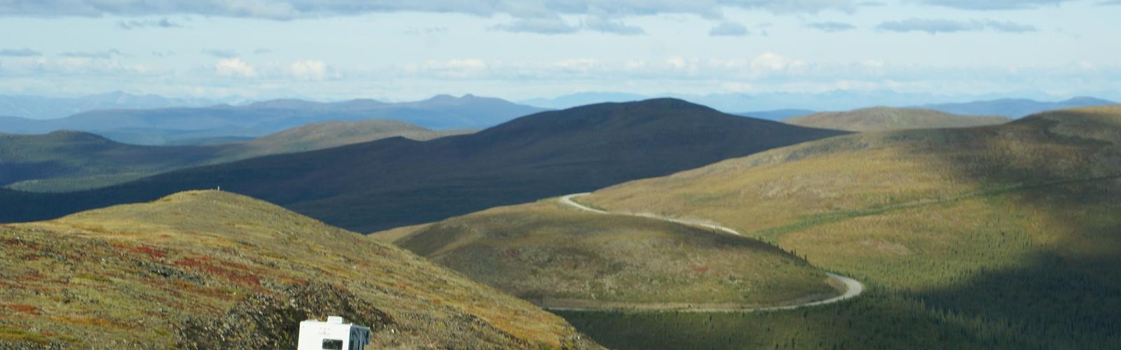
The Top of the World Highway is one of those roads that earns its name. Stretching across the high ridgelines of interior Alaska, this remote highway sits above treeline for much of its length, offering an open, exposed drive and hiking experience that feels genuinely unlike anything else in North America. The views are panoramic in every direction — rolling tundra, distant mountain ranges, and a sky that seems to go on forever. If you're looking for a place where the landscape does the heavy lifting, this is it.
What Makes This Place Unique
Most scenic highways dip in and out of viewpoints. The Top of the World Highway is different — it runs along the ridges rather than through valleys, which means you're above the clouds as often as you're under them. The tundra here is open and windswept, with low-growing vegetation that doesn't obstruct your sightlines. On a clear day, the sense of scale is hard to process. You feel genuinely small out here, and that's part of the appeal.
The highway connects Chicken, Alaska to the Yukon border at the Poker Creek–Little Gold Creek Port of Entry, making it a corridor through some of the most isolated terrain in the state. For hikers and explorers, the road itself serves as a launching point for off-trail tundra walking, wildlife watching, and simply absorbing a landscape that sees very few visitors compared to more accessible parts of Alaska.
The Terrain
The landscape along the Top of the World Highway is classic Alaskan high tundra. Expect open ground covered in low shrubs, mosses, lichens, and sedges. The terrain rolls and undulates across ridgelines, with no formal maintained hiking trails branching off in most sections. Hikers here typically walk cross-country on the tundra itself, which can range from firm and easy to soft and boggy depending on the season and recent weather.
The elevation keeps you above the boreal forest zone, so there's no dense spruce or birch to push through. What you get instead is wide-open walking with unobstructed views in every direction. The ground can be uneven underfoot — tussock grass in particular is notorious for making tundra travel slow and ankle-taxing — so sturdy footwear with good ankle support is a smart call.
Wildlife and Nature
The open tundra environment along this highway is excellent habitat for a range of Alaskan wildlife. Caribou are known to move through the area, and the elevated ridgeline position gives you a good vantage point for spotting animals across long distances. Grizzly bears are present in this part of Alaska, so bear awareness and proper food storage practices are essential. Smaller mammals like Arctic ground squirrels are common and easy to spot.
Birdwatching can be rewarding here as well. Raptors use the ridgelines for hunting, and the open tundra supports species that prefer exposed, treeless habitat. The lack of human infrastructure and low visitor traffic means wildlife encounters feel authentic and unscripted.
Practical Information
The Top of the World Highway is a gravel road for much of its length, and road conditions can vary significantly. It's typically open during the summer months, but the season is short this far north. The road can become impassable after rain or early snowfall, and it is not maintained year-round. Before heading out, checking current road conditions through the Alaska Department of Transportation is strongly recommended.
There are no trailheads, parking lots, or visitor facilities along most of the highway corridor in the traditional sense. Access is self-directed — you pull over where it's safe and head out on foot from there. This is a place that rewards self-sufficiency. Come prepared with everything you need, because services are extremely limited in this part of Alaska.
- Road surface: Gravel for most of the route — high-clearance vehicles are recommended
- Services: Extremely limited; fuel and basic supplies available in Chicken, Alaska
- Cell service: Essentially nonexistent along the corridor
- Border crossing: The Poker Creek Port of Entry at the Yukon border has limited operating hours — verify before planning a crossing
- Bear safety: Bear spray is strongly recommended; practice proper food storage at all times
- Weather: Conditions can change rapidly at elevation; layers and rain gear are essential regardless of the forecast
Getting There
The Top of the World Highway is reached via the Taylor Highway (Alaska Route 5), which branches off the Alaska Highway near Tetlin Junction, east of Tok. From there, the Taylor Highway heads north through Chicken before connecting to the Top of the World Highway at the community of Boundary. The drive from Tok to the border crossing is long and remote — plan accordingly and make sure your vehicle is in good shape before setting out.
This is not a place you stumble upon. Getting here requires deliberate planning, a reliable vehicle, and a genuine appetite for remote travel. The distance from major population centers and the lack of services along the way mean that preparation isn't optional — it's the baseline.
Who This Place Is For
The Top of the World Highway appeals most to travelers and hikers who are comfortable with remoteness and self-reliance. If you're looking for marked trails, interpretive signs, and nearby amenities, this isn't the right fit. But if you want to walk across open tundra with nothing but ridgelines and sky around you, and you're equipped to handle the logistics of a truly remote Alaskan experience, this corridor delivers something that's genuinely hard to find anywhere else.
It's also a strong destination for road-trippers doing the broader Alaska Highway loop or exploring the eastern interior of the state — the drive alone, with its sustained above-treeline views, is worth the detour for anyone who appreciates big, unfiltered landscapes.
The Essential Hiking Checklist
Everything you need for your next hike. Bilingual, printable, 1 page.
Get your free hiking checklistRecommended gear for this trail
As an Amazon Associate I earn from qualifying purchases.


Ready to go?
Everything you need to know before you goWhen?
How much?
As an Amazon Associate I earn from qualifying purchases.
Affiliate links — LGPO may earn a commission at no extra cost to you.
- Hiking shoes Essential
- → Salomon Elixir Tour Mid WP · 203.38 $
- Layered clothing Essential
- Rain jacket Essential
- Trekking poles
- → Black Diamond Trail Ergo Cork · 69.99 $
- Headlamp
- → Petzl Actik Core 625 · 103.95 $
FAQ - Frequently asked questions
Everything you need to knowSimilar hikes nearby
Discover other trails you might enjoy

Hiking near Jasper
82 trails to explore ~1811 km away
We work hard to provide the most up-to-date and error-free data possible. If something seems incorrect, let us know! Your contribution helps the whole community.
Hikers' opinions
Be the first to review!
No hiker has shared their experience yet. Share your impressions and help other hikers!