

Ready to explore Sunset Crater Volcano? Here's everything you need to know before you go!
Discover the trail
Oh no! We don't have any photos 😢
This trail hasn't been captured yet. Be the first to share your adventure!Trail description
Sunset Crater Volcano is one of the most striking geological features in Arizona — a cinder cone that erupted less than a thousand years ago and left behind a landscape that still looks raw, almost otherworldly. Located within Sunset Crater Volcano National Monument north of Flagstaff, this site gives hikers and visitors a rare chance to walk through a volcanic field that formed during recorded human history. The Sinagua people who lived in the region witnessed the eruption firsthand, and that connection between geology and human experience makes this place feel genuinely different from a typical trail destination.
The Volcanic Landscape
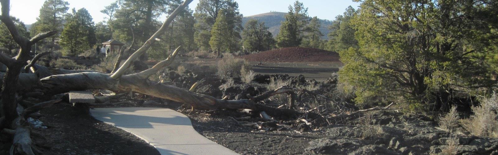
The crater itself rises dramatically above the surrounding ponderosa pine forest, its slopes covered in black and red cinders that shift and crunch underfoot. The colors near the summit — deep reds, oranges, and yellows — are what gave the volcano its name. John Wesley Powell, who explored the region in the 19th century, described the appearance as if the cone were perpetually lit by a sunset glow. That description still holds up. The contrast between the dark lava fields at the base and the warm-toned upper cone is genuinely striking, especially in the late afternoon light.
The surrounding lava flow — known as the Bonito Lava Flow — stretches out across the landscape and creates a stark, open terrain that feels almost lunar. Squeeze-up formations, lava tubes, and pressure ridges are visible throughout the flow, giving the area real geological texture. This isn't just a scenic backdrop — it's an active teaching ground for anyone curious about how volcanic landscapes form and evolve.
Trails and Access
The main trail experience at Sunset Crater Volcano National Monument is the Lava Flow Trail, a loop that takes visitors through the Bonito Lava Flow at the base of the volcano. The trail is well-maintained and accessible, winding past lava formations, cinder fields, and pockets of vegetation that have slowly reclaimed the volcanic rock over the centuries. Interpretive signs along the route explain the geology and the ecological recovery happening across the flow.
It's worth knowing upfront: hiking to the summit of Sunset Crater is not permitted. The National Park Service closed the summit trail permanently to protect the fragile cinder slopes from erosion. The crater itself is off-limits to foot traffic. This surprises some visitors who arrive expecting a summit hike, so it's good to set expectations before you go. The Lava Flow Trail is where the real experience happens anyway — walking through the flow gives you a ground-level perspective on the eruption's impact that a summit view wouldn't provide.
The Lenox Crater Trail is another option within the monument. It leads to the top of a smaller, older cinder cone nearby and offers elevated views of the volcanic field and the San Francisco Peaks to the southwest. This one does involve some climbing on loose cinder, so trekking poles can be helpful.
What to Expect on the Ground
The terrain throughout the monument is loose and uneven in places. Cinder is a particular kind of surface — it compacts underfoot but can shift unexpectedly, especially on slopes. Sturdy footwear with good ankle support makes a real difference here. The lava rock along the flow trail has sharp edges, so staying on the marked path protects both you and the landscape.
Elevation in this area sits well above 7,000 feet, which means the sun hits harder than it might feel, and afternoon thunderstorms are common during the summer monsoon season. Bring more water than you think you need, apply sunscreen even on overcast days, and keep an eye on the sky if you're out in the afternoon between July and September.
The monument is managed by the National Park Service, and an entrance fee applies. The visitor center near the entrance is worth a stop — it has exhibits on the volcanic history of the region and the Sinagua people who lived here before and after the eruption. Rangers are usually on hand and genuinely knowledgeable about the geology.
Wildlife and Vegetation
Despite the stark appearance of the lava fields, the area supports more life than it might seem at first glance. Ponderosa pines grow right up to the edges of the flow, and within the flow itself, plants like fernbush and locoweed have established footholds in cracks and depressions where soil has begun to accumulate. This ecological succession — the slow return of plant life to bare volcanic rock — is one of the quieter stories the monument tells.
Mule deer move through the area, and various bird species use the ponderosa forest surrounding the monument. The open cinder fields also attract raptors hunting across the exposed terrain.
Getting There
Sunset Crater Volcano National Monument is located along US-89 north of Flagstaff, Arizona. The turnoff to the monument road is well-signed. Parking is available at the visitor center and at trailheads within the monument. The road through the monument connects to Wupatki National Monument to the north, making it easy to combine both sites into a single day trip — a route that pairs volcanic geology with ancient Puebloan architecture in a way that's hard to match anywhere else in the region.
Good to Know Before You Go
- Summit hiking is prohibited — the Lava Flow Trail and Lenox Crater Trail are the primary hiking options.
- An entrance fee is required; passes like the America the Beautiful annual pass are accepted.
- The visitor center provides context that genuinely enhances the experience — worth 20 minutes of your time.
- Loose cinder surfaces mean sturdy footwear is strongly recommended.
- Elevation is above 7,000 feet — sun protection and hydration matter more than they might at lower elevations.
- The monument road connects directly to Wupatki National Monument for an easy combined visit.
- Dogs are allowed in the monument but check current NPS regulations for specific trail restrictions before your visit.
The Essential Hiking Checklist
Everything you need for your next hike. Bilingual, printable, 1 page.
Get your free hiking checklistRecommended gear for this trail
As an Amazon Associate I earn from qualifying purchases.


Ready to go?
Everything you need to know before you goWhen?
How much?
As an Amazon Associate I earn from qualifying purchases.
Affiliate links — LGPO may earn a commission at no extra cost to you.
- Hiking shoes Essential
- → Salomon Elixir Tour Mid WP · 203.38 $
- Layered clothing Essential
- Rain jacket Essential
- Trekking poles
- → Black Diamond Trail Ergo Cork · 69.99 $
- Headlamp
- → Petzl Actik Core 625 · 103.95 $
FAQ - Frequently asked questions
Everything you need to knowSimilar hikes nearby
Discover other trails you might enjoy
Kendrick Peak
Northern Arizona

Humphreys Peak
Northern Arizona
Doyle Peak
Northern Arizona
Hart Prairie
Northern Arizona
Gran Canyon
Northern Arizona
New Hance Trail
Northern Arizona
Hiking near Kelowna
45 trails to explore ~1739 km away
We work hard to provide the most up-to-date and error-free data possible. If something seems incorrect, let us know! Your contribution helps the whole community.
Hikers' opinions
Be the first to review!
No hiker has shared their experience yet. Share your impressions and help other hikers!