
Ready to explore Tahoe Rim Trail? Here's everything you need to know before you go!
Discover the trail
Trail description
The Tahoe Rim Trail is one of the most celebrated long-distance hiking routes in the American West. Circling the entire Lake Tahoe Basin, this trail offers an extraordinary combination of alpine scenery, dense forest, and sweeping lake views that are genuinely hard to match anywhere in California or Nevada. Whether you're tackling a short out-and-back section or planning a multi-day thru-hike, the Tahoe Rim Trail delivers a backcountry experience that stays with you long after you've unlaced your boots.
What the Trail Is
The Tahoe Rim Trail is a loop trail that traces the ridgeline surrounding Lake Tahoe, passing through two states and crossing some of the Sierra Nevada's most dramatic high-country terrain. The trail was completed in 2001 after years of volunteer-driven construction and is maintained largely by the Tahoe Rim Trail Association, a nonprofit organization that has been central to the trail's development and upkeep. The route connects multiple trailheads, making it accessible for day hikers, weekend backpackers, and thru-hikers alike.
A significant portion of the trail overlaps with the Pacific Crest Trail, particularly in the Desolation Wilderness section, which is one of the most visited wilderness areas in the United States. This overlap brings a certain prestige to the route — you're walking the same ground as PCT thru-hikers making their way from Mexico to Canada.
The Terrain
The trail rides the ridgeline for much of its length, which means you're frequently treated to views in two directions: down into the Tahoe Basin on one side and out toward the Great Basin desert on the other. That contrast — lush, lake-fed forest on one side, dry high desert on the other — is one of the things that makes the Tahoe Rim Trail feel unlike any other route in the region.
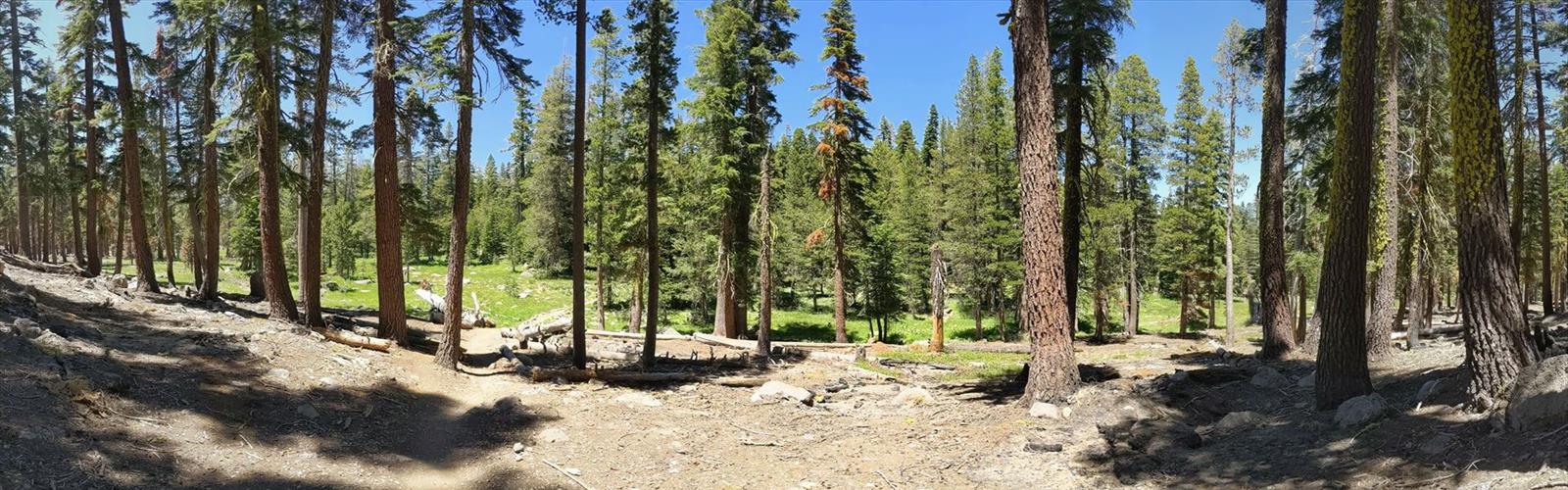
The terrain shifts considerably depending on which section you're on. Some stretches move through open granite slabs and exposed ridgelines where the wind picks up and the views are unobstructed. Others drop into dense stands of Jeffrey pine, white fir, and lodgepole pine, where the trail is soft underfoot and shaded. Meadows appear throughout the route, particularly in the northern and eastern sections, and wildflowers can be abundant during the right season.
Elevation plays a big role in the experience. The trail spends most of its time at high elevation, and the air is noticeably thinner than at the lake's shore. Hikers coming from lower elevations should plan for some adjustment time, especially if they're moving fast or carrying a heavy pack.
Highlights Along the Route
Several sections of the Tahoe Rim Trail stand out as particularly memorable:
- Desolation Wilderness: The southwestern section of the trail passes through this federally designated wilderness area, characterized by glacially carved granite basins, alpine lakes, and rocky peaks. A permit is required for overnight stays in Desolation Wilderness, and day-use permits are also required during peak season — plan ahead.
- Tahoe Meadows: Located near the Mount Rose trailhead on the Nevada side, this area offers a gentler, more open landscape with excellent wildflower viewing and a more accessible feel for families or hikers looking for a lower-intensity experience.
- Marlette Lake: Accessible from the Spooner Summit trailhead, this section passes through the Lake Tahoe Nevada State Park and reaches a beautiful backcountry lake that sees fewer crowds than some of the California-side access points.
- Freel Peak vicinity: The southern section of the trail passes near Freel Peak, the highest point in the Lake Tahoe Basin. The views from this area are expansive and the terrain is rugged — this is one of the more demanding stretches of the route.
Wildlife and Nature
The Tahoe Rim Trail passes through habitat that supports a wide range of wildlife. Black bears are present throughout the basin and are commonly encountered, particularly near campsites. Bear canisters are required for overnight trips in many sections of the trail, including Desolation Wilderness. Mule deer are frequently spotted, especially in meadow areas during early morning and evening hours. Marmots are a regular presence on the rocky, exposed sections of the ridgeline.
Birdlife along the trail includes Clark's nutcrackers, Steller's jays, and various raptors that use the thermals rising off the ridgeline. The forests support a healthy population of smaller mammals including pikas, which are often heard before they're seen — their sharp, distinctive call echoing off the rocks.
Practical Information
The Tahoe Rim Trail has multiple trailheads spread around the basin, giving hikers a lot of flexibility in how they approach the route. Popular access points include Tahoe City, Brockway Summit, Spooner Summit, Echo Lake, and South Lake Tahoe. Each trailhead has its own parking situation, and some fill up quickly on summer weekends — arriving early is strongly recommended.
Dogs are permitted on most sections of the trail but are not allowed in Desolation Wilderness. Mountain bikes are allowed on roughly half the trail, specifically on sections outside of designated wilderness areas. Check the Tahoe Rim Trail Association's current maps and regulations before heading out, as rules can vary by segment and are updated periodically.
Water sources exist along the trail but should always be treated before drinking. Conditions vary significantly by section and by time of year — some creek crossings that are straightforward in late summer can be challenging or dangerous during early season snowmelt. Snow can linger on higher sections well into June, and some years even later.
Who This Trail Is For
The Tahoe Rim Trail works for a wide range of hikers precisely because it isn't a single experience — it's a collection of very different sections that can be sampled individually or linked together. A family looking for a scenic half-day walk can find that at Tahoe Meadows. A seasoned backpacker looking for a serious multi-day challenge can find that in the Desolation Wilderness or the southern high-country sections. Thru-hikers completing the full loop will need solid backcountry experience, good navigation skills, and the ability to manage variable mountain weather.
What ties all of it together is the lake itself — that deep blue presence that appears and disappears through the trees, always reminding you where you are and why this particular trail has earned its reputation as one of the finest in the West.
In winter
According to the Tahoe Rim Trail Association, the trail never officially closes, but it is not marked for winter use: trail junctions, confidence markers and signs may be covered under snow. In an average snow year, the majority of the trail is covered in snow from late October to mid-June; north-facing trails, high points such as Relay Peak, and Desolation Wilderness stay covered longer, while south-facing, lower-elevation trails and those along the east shore melt out first. Don't expect most trailheads to be plowed, and roadside parking is limited; the association says winter trailhead parking may be available at 64 Acre Park in Tahoe City, the Brockway West and Mt. Rose Summit trailheads, and Kingsbury North. Barker Pass's seasonal gate closure prevents road access from October until June, and the Kingsbury South trailhead, shared with the Heavenly Stagecoach ski area, is off limits for trail use during the ski season. For avalanche information in the Tahoe Basin, the association points to the Sierra Nevada Avalanche Center.
The association's trail conditions report, updated November 2, 2026, describes early-winter conditions (frosty mornings) and suggests traction devices and trekking poles in snowy, icy or variable conditions. It says the Brockway to Mt. Rose segment is high-elevation and will retain early-winter snow, and that the Big Meadow trailhead gate is closed during winter months with the presence of snow and ice. It also reports that the trail is closed from the Barker Pass Trailhead to the TRT/PCT junction at Twin Peaks because of the Talbot Fire, and asks visitors to stay out of the area so crews can work.
Everything you need for your next hike. Bilingual, printable, 1 page.
Get your free hiking checklistRecommended gear for this trail
As an Amazon Associate I earn from qualifying purchases.


Ready to go?
Everything you need to know before you goWhen?
As an Amazon Associate I earn from qualifying purchases.
Affiliate links — LGPO may earn a commission at no extra cost to you.
- Hiking shoes Essential
- → Salomon Elixir Tour Mid WP · 203.38 $
- Layered clothing Essential
- Rain jacket Essential
- Trekking poles
- → Black Diamond Trail Ergo Cork · 69.99 $
- Headlamp
- → Petzl Actik Core 625 · 103.95 $
FAQ - Frequently asked questions
Everything you need to knowOutings near Tahoe Rim Trail
Discover other trails you might enjoy
East Rim Trail
Southern Utah · 21.1 km away

San Rafael River
22.3 km away
Grottos Trail
South Central Wisconsin · 27.2 km away
Baltimore & Annapolis Trail Park
Central Maryland · 41.5 km away
New Jersey Striper Fishing
63.2 km away
Coyote Gulch
Gold Country · 69.7 km away
Hiking near Sydney
25 trails to explore ~7624 km away
We work hard to provide the most up-to-date and error-free data possible. If something seems incorrect, let us know! Your contribution helps the whole community.
Hikers' opinions
Be the first to review!
No hiker has shared their experience yet. Share your impressions and help other hikers!