

Ready to explore Castro Peak, California? Here's everything you need to know before you go!
Discover the trail
Oh no! We don't have any photos 😢
This trail hasn't been captured yet. Be the first to share your adventure!Trail description
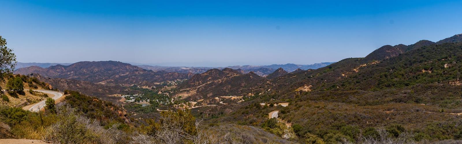
Castro Peak sits in the Santa Monica Mountains above Malibu, and it's one of those spots that rewards the effort with sweeping views over the Pacific and the surrounding ridgelines. The climb to the summit is a genuine workout — rocky, exposed in places, and satisfying in a way that a lot of Southern California trails simply aren't. If you're looking for something with a bit more character than a groomed fire road loop, Castro Peak delivers.
The Terrain
The approach to Castro Peak moves through classic Santa Monica Mountains chaparral — dense stands of chamise, toyon, and ceanothus that crowd the trail and fill the air with a sharp, resinous scent, especially after any rain. The vegetation is thick and low, which means shade is limited, so plan accordingly on warm days.
As you gain elevation, the trail gets rockier and the footing demands more attention. The final push to the summit involves some hands-on scrambling — nothing technical, but you'll want to watch your step on loose rock. The summit itself is marked by a communication tower, which is a bit of a visual letdown up close, but the views from the top more than make up for it. On a clear day, you can see across the Malibu coast, out over the Pacific, and deep into the Santa Monica Mountains interior.
What Makes Castro Peak Stand Out
In a mountain range that's largely defined by its fire roads and well-worn connector trails, Castro Peak offers something a little different: actual climbing. The scramble to the top gives the route a more adventurous feel than most hikes in the greater Los Angeles area, and the summit elevation puts you genuinely above the surrounding terrain in a way that feels earned.
The views toward the ocean are a big part of the appeal. The Santa Monica Mountains run east-west, which means the ridgelines funnel your sightlines directly toward the coast. On days when the marine layer has cleared, the Pacific stretches out to the horizon in a way that's hard to find anywhere else this close to the city.
The area also sits within the Santa Monica Mountains National Recreation Area, which means the land is protected and managed for conservation alongside recreation. The chaparral ecosystem here is one of the most biodiverse in North America, and the birdwatching along the approach can be genuinely good — raptors are common, and the scrub habitat supports a wide variety of species.
Access and Trailhead
The trailhead for Castro Peak is accessible from Latigo Canyon Road, which winds up from the Pacific Coast Highway into the mountains above Malibu. The road itself is narrow and twisting, so take it slow. Parking at the trailhead is limited — arrive early, especially on weekends, because this area draws a crowd once the morning fog burns off.
The trail connects into the broader network of paths in the Santa Monica Mountains, including links to Backbone Trail segments. If you want to extend your day or combine routes, there are options, but Castro Peak on its own is a solid objective.
Practical Notes
- Sun exposure: The chaparral offers almost no shade. A hat, sunscreen, and more water than you think you need are non-negotiable, particularly from late spring through early fall.
- Footing: The scramble near the summit involves loose rock. Sturdy footwear with ankle support is a smart call — trail runners work, but hiking boots are better for the final section.
- Wind: The summit is exposed and can be significantly windier than the trailhead. A light layer in your pack is worth it even on warm days.
- Wildlife: The Santa Monica Mountains are home to mountain lions, rattlesnakes, and coyotes. Stay aware, especially in the early morning and at dusk.
- Fire history: Like much of the Santa Monica Mountains, this area has burned in recent years. Trail conditions and vegetation density can vary depending on how recently a fire moved through — check current conditions before heading out.
- Cell service: Spotty to nonexistent on much of the trail. Download an offline map before you go.
Who This Hike Is For
Castro Peak is best suited for hikers who are comfortable on uneven, rocky terrain and don't mind a bit of scrambling. It's not a beginner trail — the combination of elevation gain, sun exposure, and the technical nature of the summit approach puts it in intermediate-to-advanced territory. That said, it's not a mountaineering objective either. Fit hikers with some trail experience will handle it without issue.
If you're bringing kids, be honest about their comfort level on loose rock and exposed ridgelines. Younger children or less experienced hikers might find the upper section stressful.
Dogs are a common sight on Santa Monica Mountains trails, but check current regulations for this specific area before bringing yours — rules can vary by trail segment and land management unit within the national recreation area.
Best Times to Visit
Fall and spring are the sweet spots for Castro Peak. Temperatures are manageable, the chaparral can be blooming, and the air tends to be clearer, which means better views. Summer mornings work if you start early enough to beat the heat, but midday in July or August on an exposed ridge above Malibu is genuinely brutal. Winter is generally fine and can offer the clearest views of the year, though the scramble section can be slippery after rain.
Castro Peak is the kind of place that reminds you why people put up with Los Angeles traffic — because within an hour of the city, you can be on a rocky ridgeline above the Pacific with the chaparral stretching out in every direction and the ocean glittering below.
The Essential Hiking Checklist
Everything you need for your next hike. Bilingual, printable, 1 page.
Get your free hiking checklistRecommended gear for this trail
As an Amazon Associate I earn from qualifying purchases.


Ready to go?
Everything you need to know before you goWhen?
How much?
As an Amazon Associate I earn from qualifying purchases.
Affiliate links — LGPO may earn a commission at no extra cost to you.
- Hiking shoes Essential
- → Salomon Elixir Tour Mid WP · 203.38 $
- Layered clothing Essential
- Rain jacket Essential
- Trekking poles
- → Black Diamond Trail Ergo Cork · 69.99 $
- Headlamp
- → Petzl Actik Core 625 · 103.95 $
FAQ - Frequently asked questions
Everything you need to knowSimilar hikes nearby
Discover other trails you might enjoy

Mount Lowe, California
Greater Los Angeles
Mount Lukens, California
Greater Los Angeles
Mount Wilson, California
Greater Los Angeles
Mount Zion, California
Greater Los Angeles
Lake Piru
Greater Los Angeles
South Coast Botanic Garden
Greater Los Angeles
Hiking near Victoria
93 trails to explore ~1638 km away
We work hard to provide the most up-to-date and error-free data possible. If something seems incorrect, let us know! Your contribution helps the whole community.
Hikers' opinions
Be the first to review!
No hiker has shared their experience yet. Share your impressions and help other hikers!