
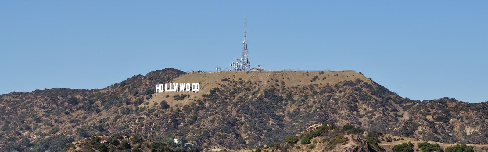

Ready to explore Mount Lee, California? Here's everything you need to know before you go!
Discover the trail
Oh no! We don't have any photos 😢
This trail hasn't been captured yet. Be the first to share your adventure!Trail description
Mount Lee is one of the most iconic hikes in the Greater Los Angeles area — and honestly, one of the most recognizable destinations on the planet. This is the hill that holds the Hollywood Sign, and hiking up to it puts you right behind those giant white letters that have symbolized the entertainment industry for over a century. It's a real hike with real elevation, not just a tourist stroll, and the views you get at the top make the effort completely worth it.
What Makes This Hike Stand Out
Most people see the Hollywood Sign from a distance — from the freeway, from a rooftop bar, from a tour bus. Hiking Mount Lee flips that perspective entirely. Instead of looking at the sign, you end up standing directly above and behind it, looking out over the entire Los Angeles Basin. On a clear day, the view stretches from downtown LA all the way to the Pacific Ocean. That combination of cultural landmark and genuine panoramic payoff is what keeps this trail consistently busy and consistently worth doing.
The hike itself takes you through Griffith Park, the massive urban park that covers the eastern end of the Santa Monica Mountains. The terrain is dry and exposed for much of the route, typical of Southern California chaparral — scrubby brush, dusty fire roads, and open ridgelines. It's not a lush forest walk, but the openness is part of what gives you those sweeping views throughout the climb, not just at the summit.
The Route
The most common way to reach the summit of Mount Lee is via the Brush Canyon Trail, which starts from the Canyon Drive trailhead in Griffith Park. This route follows a fire road up through the canyon before connecting to the Mount Lee Drive fire road that loops around to the summit area and the antenna facility just above the Hollywood Sign.
There are a few other approach options as well. Some hikers come up from the Beachwood Canyon side, which has its own trailhead and a slightly different character — more residential neighborhood feel at the start, with the trail climbing steadily through the hills. The Hollyridge Trail from Beachwood Drive is a popular choice for those coming from that direction.
Whichever way you go, the final stretch brings you to the restricted area around the sign itself. You can't touch the letters or get right up to them — there's a fence and security cameras — but the viewpoint directly above and behind the sign is accessible and gives you that classic shot looking down at the H-O-L-L-Y-W-O-O-D letters with the city sprawling out below.
Terrain and Trail Conditions
The trails on Mount Lee are primarily fire roads — wide, unpaved, and well-maintained. The surface is packed dirt and gravel, which can get loose and dusty in dry conditions. There's very little shade on most of the route, so the exposed sections can feel significantly hotter than the temperature suggests, especially in the afternoon. Mornings are strongly preferred, both for cooler temperatures and for better air quality and visibility.
The grade is steady rather than brutal — you're climbing consistently, but it's not a scramble or a technical climb. Sturdy trail runners or hiking shoes are more than adequate. Trekking poles aren't necessary but some people appreciate them on the descent when the loose gravel can make footing a bit unpredictable.
What You'll See Along the Way
Beyond the Hollywood Sign itself, the summit of Mount Lee offers some of the best unobstructed views in all of Los Angeles. Looking south and west, you get the full urban sprawl of the LA Basin — downtown skyscrapers, the Wilshire corridor, Century City, and on clear days the coastline from Santa Monica down toward Palos Verdes. To the north, you can see into the San Fernando Valley. The Griffith Observatory sits on the ridge to the east, and you can often spot it clearly from the upper sections of the trail.
The chaparral vegetation along the trail is classic Southern California — black sage, laurel sumac, toyon, and various native grasses. Wildlife is present in Griffith Park, including mule deer, coyotes, and a wide variety of birds, though the busier sections of this trail see enough foot traffic that wildlife sightings are less common than on quieter park trails.
Practical Information
- Trailheads: The main access points are the Canyon Drive trailhead (Brush Canyon Trail) and the Beachwood Canyon trailhead (Hollyridge Trail). Both are within Griffith Park.
- Parking: Street parking is available near both trailheads, but it fills up quickly, especially on weekends. Arriving early is the best strategy. The Canyon Drive trailhead has a small parking area that gets congested fast.
- Dogs: Dogs are allowed on the trails in Griffith Park and on this route, but must be kept on leash.
- Fees: There is no fee to hike in Griffith Park or to access the Mount Lee trails.
- Water: There are no water sources on the trail. Carry more than you think you need — the exposed, sunny terrain in Southern California can dehydrate you faster than expected.
- Crowds: This is one of the most visited hikes in Los Angeles. Weekday mornings are significantly quieter than weekend afternoons. If you want a more peaceful experience, aim for early on a weekday.
- Cell coverage: Strong throughout, given the urban setting.
Getting There
Mount Lee is located within Griffith Park in Los Angeles. For the Brush Canyon / Canyon Drive trailhead, navigate to the end of Canyon Drive off of Beachwood Drive in the Hollywood Hills. For the Beachwood Canyon approach, the trailhead is accessible from Beachwood Drive, with street parking available along the residential streets below. Both approaches are well-documented on mapping apps and easy to find.
There is no direct public transit to the trailheads, though rideshare drop-off is a common option given the parking challenges, especially on busy weekends.
The Essential Hiking Checklist
Everything you need for your next hike. Bilingual, printable, 1 page.
Get your free hiking checklistRecommended gear for this trail
As an Amazon Associate I earn from qualifying purchases.


Ready to go?
Everything you need to know before you goWhen?
How much?
As an Amazon Associate I earn from qualifying purchases.
Affiliate links — LGPO may earn a commission at no extra cost to you.
- Hiking shoes Essential
- → Salomon Elixir Tour Mid WP · 203.38 $
- Layered clothing Essential
- Rain jacket Essential
- Trekking poles
- → Black Diamond Trail Ergo Cork · 69.99 $
- Headlamp
- → Petzl Actik Core 625 · 103.95 $
FAQ - Frequently asked questions
Everything you need to knowSimilar hikes nearby
Discover other trails you might enjoy

Mount Lowe, California
Greater Los Angeles
Mount Lukens, California
Greater Los Angeles
Mount Wilson, California
Greater Los Angeles
Mount Zion, California
Greater Los Angeles
Lake Piru
Greater Los Angeles
South Coast Botanic Garden
Greater Los Angeles
Hiking near Victoria
93 trails to explore ~1642 km away
We work hard to provide the most up-to-date and error-free data possible. If something seems incorrect, let us know! Your contribution helps the whole community.
Hikers' opinions
Be the first to review!
No hiker has shared their experience yet. Share your impressions and help other hikers!