

Ready to explore Mount Lukens, California? Here's everything you need to know before you go!
Discover the trail

Trail description
Mount Lukens is the highest peak within the city limits of Los Angeles, and that fact alone makes it worth knowing about. Tucked into the eastern end of the San Gabriel Mountains, just north of the city, it offers a genuine summit experience without requiring you to drive hours into the backcountry. If you're based in the greater LA area and looking for a real climb — not just a walk in the park — Mount Lukens delivers.
The Summit and What Makes It Stand Out
Standing as the highest point within Los Angeles city boundaries, Mount Lukens carries a certain bragging right that hikers and peak baggers in Southern California take seriously. The summit sits above the urban sprawl, and on a clear day the views stretch across the LA basin, out toward the Pacific, and deep into the San Gabriel range. It's the kind of payoff that makes the effort feel worthwhile.
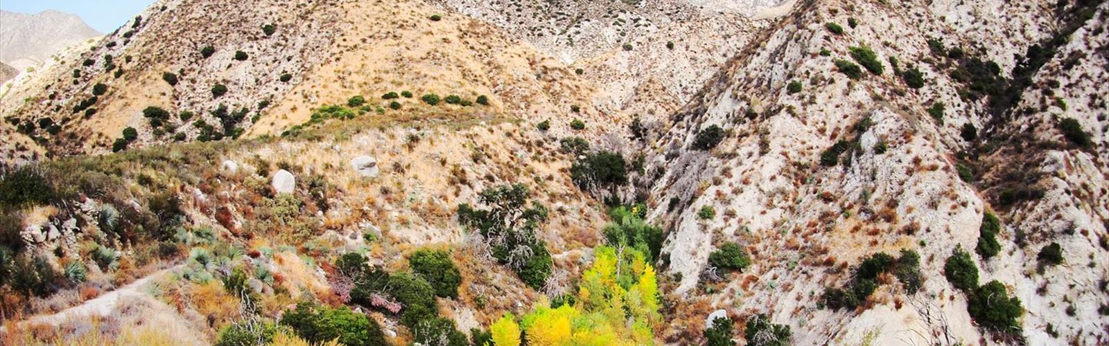
The mountain is part of the Angeles National Forest, which means you're stepping into federally managed land the moment you leave the trailhead. The terrain here is classic Southern California chaparral — dense shrubs, exposed ridgelines, and rocky slopes that catch the sun hard. There's nothing soft about this landscape, and that's part of the appeal.
The Climb
Mount Lukens isn't a casual stroll. The routes that lead to the summit involve sustained elevation gain on exposed terrain, and the chaparral offers little shade along the way. This is a mountain that asks something of you physically, and you'll want to come prepared.
The most commonly used approach follows the Stone Canyon Trail, which climbs steadily through the brushy hillsides above the community of Tujunga. The trail is well-established but not heavily maintained, so expect some rough patches, loose rock in places, and sections where the vegetation crowds the path. Trekking poles are a smart call here, especially on the descent when your legs are already tired and the footing gets unpredictable.
There's also a road route via Grizzly Flat Road that some hikers use, though the trail approach is generally considered the more rewarding option. Either way, you're working for this summit.
Terrain and Environment
The vegetation on Mount Lukens is quintessential Southern California chaparral — chamise, manzanita, scrub oak, and sage dominate the slopes. It's dense, aromatic, and in some sections nearly impenetrable off-trail. Stick to the established paths and you'll be fine. The landscape has a rugged, almost austere beauty to it, especially in the early morning light when the air is still cool and the city below is just waking up.
Wildlife is present, though often discreet. Mule deer, coyotes, and a variety of raptors are part of the ecosystem here. The area is also known for its bird diversity, which makes it interesting for those who pay attention to what's flying overhead as they climb.
The exposed ridgeline near the summit can be windy, and the temperature difference between the base and the top is noticeable. Layers are a good idea even on days that feel warm at the trailhead.
Practical Information
- Location: Eastern San Gabriel Mountains, Angeles National Forest, within the city limits of Los Angeles, California
- Access: The Stone Canyon Trail is the primary hiking approach; trailhead access is available from the Tujunga area
- Permits and fees: The Angeles National Forest may require an Adventure Pass for parking at certain trailheads — check current requirements before you go
- Dogs: Generally permitted on leash in Angeles National Forest; confirm current rules for the specific trailhead you're using
- Water: There is no reliable water source on the trail — carry everything you need from the start
- Cell service: Variable; don't count on it once you're on the upper slopes
When to Go
The exposed nature of Mount Lukens makes timing important. Summer midday heat on these south-facing chaparral slopes can be brutal, and the lack of shade means there's nowhere to escape it. Early morning starts are strongly recommended if you're hiking between late spring and early fall — aim to be on the trail before sunrise if possible, and plan to be off the exposed upper sections before 10 or 11 a.m.
Fall, winter, and spring offer the most comfortable conditions. Winter can bring snow to the upper elevations, which changes the character of the climb significantly and requires appropriate footwear and preparation. After winter rains, the chaparral comes alive and the air smells incredible — it's one of the best times to be on this mountain.
Who This Hike Is For
Mount Lukens is best suited for hikers who already have some experience with sustained climbs and exposed terrain. It's not a beginner destination, and the combination of elevation gain, heat potential, and limited shade means you need to be honest with yourself about your fitness level and preparation before heading out.
That said, it's also not a technical climb — no ropes, no scrambling, no specialized gear required beyond solid footwear and enough water. For fit hikers looking to bag a meaningful LA-area summit, it's a legitimate objective that rewards the effort with a genuine sense of accomplishment and views that put the entire city in perspective.
Getting There
The mountain is accessible from the Sunland-Tujunga area on the northern edge of Los Angeles. The Stone Canyon Trail trailhead is the standard starting point for hikers. GPS navigation will get you close, but it's worth reviewing the specific trailhead location in advance since signage in this area can be inconsistent. Parking is limited, and arriving early on weekends is advisable both to secure a spot and to beat the heat.
Mount Lukens sits at a unique intersection of urban accessibility and genuine mountain terrain — it's the kind of place that reminds you how much wild landscape still exists right at the edge of one of the largest cities in North America.
The Essential Hiking Checklist
Everything you need for your next hike. Bilingual, printable, 1 page.
Get your free hiking checklistRecommended gear for this trail
As an Amazon Associate I earn from qualifying purchases.


Ready to go?
Everything you need to know before you goWhen?
How much?
As an Amazon Associate I earn from qualifying purchases.
Affiliate links — LGPO may earn a commission at no extra cost to you.
- Hiking shoes Essential
- → Salomon Elixir Tour Mid WP · 203.38 $
- Layered clothing Essential
- Rain jacket Essential
- Trekking poles
- → Black Diamond Trail Ergo Cork · 69.99 $
- Headlamp
- → Petzl Actik Core 625 · 103.95 $
FAQ - Frequently asked questions
Everything you need to knowSimilar hikes nearby
Discover other trails you might enjoy

Mount Lowe, California
Greater Los Angeles

Mount Wilson, California
Greater Los Angeles
Mount Zion, California
Greater Los Angeles
Lake Piru
Greater Los Angeles

South Coast Botanic Garden
Greater Los Angeles

Port Hueneme
Greater Los Angeles
Hiking near Victoria
93 trails to explore ~1629 km away
We work hard to provide the most up-to-date and error-free data possible. If something seems incorrect, let us know! Your contribution helps the whole community.
Hikers' opinions
Be the first to review!
No hiker has shared their experience yet. Share your impressions and help other hikers!