

Ready to explore Mount Lowe, California? Here's everything you need to know before you go!
Discover the trail
Trail description
Description
Mount Lowe rises from the southern edge of the San Gabriel Mountains, offering one of the more historically layered hikes in the Greater Los Angeles area. At 11.3 kilometers round-trip with 1,708 meters of elevation gain, this is a genuinely demanding route — the kind that earns its views. Plan for around 5 hours and 30 minutes on the trail, and go in knowing that the climb is relentless from start to finish.
The peak was originally called Oak Mountain before being renamed to honor Professor Thaddeus S.C. Lowe, credited as the first person to reach its summit and plant an American flag there. The name was cemented by Andrew McNally, the prominent Chicago map publisher and Altadena summer resident, who committed to featuring "Mount Lowe" on all his published maps. The mountain's profile rose further when Professor Lowe built the Mount Lowe Railway to its base in 1896 — an ambitious project originally incorporated as the Pasadena and Mt. Wilson Railroad Company, pivoting to Mount Lowe after failed attempts to secure rights of way to the more prominent Mount Wilson.
Trail Character and Terrain
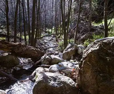
The route follows a fire road graded directly over the old railway right-of-way, which means a wide, well-defined path with no route-finding required. That's one of the few concessions this hike makes to ease. The grade is sustained and unrelenting, demanding solid cardiovascular fitness and a disciplined pace from the start. There's no technical scrambling, no exposed ridgeline navigation — just a long, steady push uphill that will test your endurance more than your agility.
The terrain shifts noticeably as you gain elevation. Lower sections move through classic Southern California chaparral, the kind of dense, sun-baked scrub that defines the foothills. Higher up, the vegetation transitions into mixed coniferous forest, and the air noticeably cools. That shift in environment is one of the more satisfying aspects of the climb — you genuinely feel like you've traveled somewhere by the time you reach the upper mountain.
The fire road's width means you'll rarely feel cramped, and the surface is stable underfoot throughout. What it lacks in technical challenge, it more than compensates for in sheer physical output.
Views Along the Way
The exposed nature of much of the route works in your favor when it comes to scenery. Views open up early and keep improving with every hundred meters of elevation gained. By the upper sections of the climb, you're looking out over the San Gabriel Valley, downtown Los Angeles, and on a clear day, all the way to the Pacific Ocean. The contrast between the dense urban grid below and the rugged mountain terrain you're standing in is genuinely striking — it's one of those moments that makes the effort feel worthwhile.
Historical Significance
Mount Lowe served as the upper terminus of the Alpine Division of the Mount Lowe Railway, and the mountain was once a legitimate tourist destination in its own right. The Mount Lowe Tavern, built at Crystal Springs just below the summit, operated from 1895 to 1936 and anchored an entire network of recreational trails and attractions.
Among the most notable was the "Mount Lowe Eight" — a figure-eight mule ride that began at the tavern, ascended to the summit, returned to the tavern, then wound down through Castle Canyon to the Echo Mountain resort before looping back to complete the circuit. Early 20th-century visitors came up from Los Angeles specifically to escape the city's growing sprawl, which gives today's hike an oddly timeless quality. You're doing essentially what people did over a century ago, just without the mule.
Access and Starting Points
Two main trailheads serve Mount Lowe: Echo Mountain and the Chaney Trail. Both routes converge on the same fire road system that leads to the summit, but they offer meaningfully different experiences on the way there.
Starting from Echo Mountain connects you to additional ruins and remnants of the old railway infrastructure — a good choice if the historical dimension of the hike interests you. The Chaney Trail approach is more direct and gets you onto the main climbing route a bit faster. Neither option is dramatically easier than the other in terms of physical effort; the elevation gain is the constant regardless of where you start.
What to Bring
Water is non-negotiable on this route. The exposed sections offer minimal shade, and the sustained climbing burns through your reserves faster than you might expect. Carry at least 2 to 3 liters per person, more in warmer months. Sun protection — sunscreen, a hat, sunglasses — is equally important given how much of the route sits in open terrain.
Layered clothing makes sense here. The temperature difference between the trailhead and the summit can be significant, particularly in winter when the upper mountain may carry snow while the lower elevations stay mild. An early morning start is strongly advisable during summer, both to beat the heat and to catch the clearest views before afternoon haze settles over the basin.
The 5-hour-30-minute estimate assumes a moderate pace with short breaks. Fit hikers moving steadily may finish faster; those taking their time with the history or the views should budget more. Either way, this is a full-day commitment worth making.
Recommended gear for this trail


Ready to go?
Everything you need to know before you goStarting Point
To access the hiking trails, you can start at several trailheads:
Eaton Saddle Trailhead: Located on Mount Wilson Red Box Road. From the Angeles Crest Highway (CA-2), turn onto Mount Wilson Red Box Road and continue until you reach the parking area near Eaton Saddle.
Cobb Estate Trailhead: Situated at the end of Lake Avenue in Altadena. The address is 3302 Lake Ave, Altadena, CA 91001. Parking is available along the street.
Millard Campground Trailhead: Accessible via Chaney Trail Road off of West Loma Alta Drive in Altadena. Follow Chaney Trail to the campground where parking is available.
Each trailhead provides a different route to explore the area, so choose based on your preferred starting point or trail difficulty.
When?
How much?
- Hiking shoes Essential
- → Salomon Elixir Tour Mid WP · 203.38 $
- Layered clothing Essential
- Rain jacket Essential
- Trekking poles
- → Black Diamond Trail Ergo Cork · 69.99 $
- Headlamp
- → Petzl Actik Core 625 · 103.95 $
FAQ - Frequently asked questions
Everything you need to knowThe Essential Hiking Checklist
Everything you need for your next hike. Bilingual, printable, 1 page.
Download the free checklistSimilar hikes nearby
Discover other trails you might enjoy

Saddle Peak, California
Greater Los Angeles
Burnt Peak, California
Greater Los Angeles
Castro Peak, California
Greater Los Angeles
Cobblestone Mountain, California
Greater Los Angeles
Cummings Mountain, California
Greater Los Angeles
Double Mountain, California
Greater Los Angeles
Hiking near Victoria
93 trails to explore ~1636 km away
We work hard to provide the most up-to-date and error-free data possible. If something seems incorrect, let us know! Your contribution helps the whole community.
Hikers' opinions