

Ready to explore Starved Rock? Here's everything you need to know before you go!
Discover the trail
Oh no! We don't have any photos 😢
This trail hasn't been captured yet. Be the first to share your adventure!Trail description
Starved Rock State Park is one of Illinois' most visited and beloved natural destinations — and once you set foot on its trails, it's easy to understand why. Tucked along the south bank of the Illinois River, this park delivers a landscape that feels genuinely surprising for the Midwest: dramatic sandstone canyons, towering bluffs, and waterfalls that cascade into moss-lined gorges. It's the kind of place that earns repeat visits across every season.
The Terrain
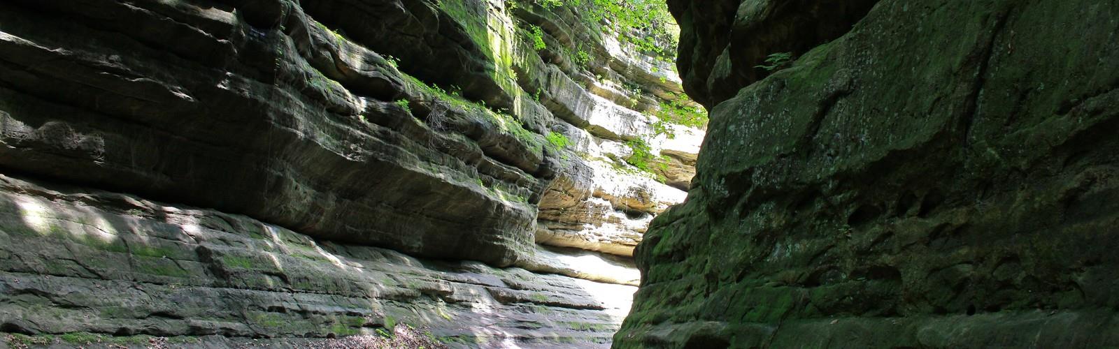
The defining feature of Starved Rock is its network of canyons carved by glacial meltwater thousands of years ago. The canyon walls are made of St. Peter sandstone, and over millennia, streams have cut deep into the rock, creating narrow gorges with sheer walls draped in ferns, mosses, and liverworts. The canyon floors stay cool and shaded even in summer, giving them an almost otherworldly feel compared to the open bluffs above.
The bluffs themselves rise sharply above the Illinois River, offering wide, open views of the water and the surrounding floodplain. The contrast between the exposed, sunny ridgelines and the dark, humid canyon interiors is one of the things that makes hiking here feel varied and engaging — even on shorter loops.
Waterfalls and Canyons
Starved Rock is home to numerous named canyons, each with its own character. French Canyon, LaSalle Canyon, and St. Louis Canyon are among the most popular, and each offers a different experience. Some canyons have year-round waterfalls fed by springs; others are more dramatic after rainfall or during the spring snowmelt. In winter, the falls can freeze into spectacular ice formations, which draws a significant crowd of hikers and photographers from across the region.
The canyon trails typically involve some scrambling over rocks and roots, and the footing can be slippery when wet or icy. Sturdy footwear with good grip is genuinely important here — this isn't a place where sneakers serve you well, especially if you're heading into the canyon interiors.
The Starved Rock Landmark
The park takes its name from a 125-foot sandstone butte — Starved Rock itself — that rises directly above the Illinois River. The site carries significant Indigenous history: according to historical accounts, a group of Illiniwek people took refuge on the butte in the late 1700s and were besieged there by warriors from other nations, ultimately dying of starvation. The rock is accessible via trail and offers one of the best elevated views in the park. Interpretive signage on-site provides historical context about the Indigenous peoples who lived in and traveled through this region long before European contact.
Trail Network
The park has an extensive trail system connecting the blufftops, canyon floors, and river's edge. Trails range from short, accessible walks to longer routes that link multiple canyons in a single outing. Most of the canyon trails are relatively short in isolation, but they connect to each other, allowing hikers to string together a longer day by moving from one canyon to the next along the bluff trail. The terrain shifts noticeably as you move between sections — open and breezy on the ridges, enclosed and cool in the canyons.
Some sections of trail involve wooden staircases and boardwalks, particularly where the terrain drops steeply into canyon entrances. These are well-maintained but can get crowded on weekends, especially near the most popular waterfalls.
Wildlife and Ecology
The park sits within the Illinois River valley, a significant corridor for migratory birds. Bald eagles are commonly spotted along the river, particularly in late fall and winter when they congregate near open water. The canyon interiors support plant communities that are more typical of cooler, northern climates — a relic of the post-glacial environment — which gives the park an ecological character distinct from the surrounding agricultural landscape of central Illinois.
White-tailed deer are frequently seen throughout the park, and the river bottomlands support a variety of waterfowl and shorebirds during migration seasons.
Practical Information
Starved Rock State Park is managed by the Illinois Department of Natural Resources. The park has a large visitor center near the main entrance, which includes exhibits on the park's geology, ecology, and history. Restrooms, drinking water, and picnic areas are available. The Starved Rock Lodge, located within the park, offers lodging and dining and has been operating since the 1930s — it's a historic structure worth a look even if you're not staying there.
- Parking: Multiple parking areas are available throughout the park, including lots near the main lodge and at trailheads for the east and west sections of the trail system. Parking can fill up quickly on weekends and holidays, particularly in spring and fall.
- Fees: There is no entrance fee to access the trails at Starved Rock State Park.
- Dogs: Leashed dogs are permitted on the trails.
- Accessibility: Some areas near the visitor center and along the river are accessible, but the canyon trails involve uneven terrain, steps, and scrambling that make them challenging for those with limited mobility.
- Seasons: The park is open year-round. Spring brings the highest waterfall flow and wildflower blooms. Winter offers frozen waterfall scenery and eagle watching along the river. Summer is the busiest season. Fall foliage draws large crowds in October.
Getting There
Starved Rock State Park is located near Utica, Illinois, roughly 90 miles southwest of Chicago along the Illinois River. The main entrance is off Illinois Route 178. The park is well-signed from the surrounding highways, and the drive from Chicago makes it a very manageable day trip — which explains a lot of the weekend crowds.
Tips for Your Visit
- Arrive early on weekends — the main parking lots fill up by mid-morning during peak seasons.
- Waterproof boots or trail shoes with solid grip are strongly recommended, especially for canyon exploration.
- Bring trekking poles if you have them; the canyon descents can be steep and slippery after rain.
- Check trail conditions before you go — some canyon trails close temporarily after heavy rain due to flooding or ice hazards.
- If you want a quieter experience, head to the east canyons (Wildcat Canyon, Ottawa Canyon) rather than the heavily trafficked west section near the lodge.
The Essential Hiking Checklist
Everything you need for your next hike. Bilingual, printable, 1 page.
Get your free hiking checklistRecommended gear for this trail
As an Amazon Associate I earn from qualifying purchases.


Ready to go?
Everything you need to know before you goWhen?
How much?
As an Amazon Associate I earn from qualifying purchases.
Affiliate links — LGPO may earn a commission at no extra cost to you.
- Hiking shoes Essential
- → Salomon Elixir Tour Mid WP · 203.38 $
- Layered clothing Essential
- Rain jacket Essential
- Trekking poles
- → Black Diamond Trail Ergo Cork · 69.99 $
- Headlamp
- → Petzl Actik Core 625 · 103.95 $
FAQ - Frequently asked questions
Everything you need to knowSimilar hikes nearby
Discover other trails you might enjoy



Hiking near Kitchener
142 trails to explore ~738 km away
We work hard to provide the most up-to-date and error-free data possible. If something seems incorrect, let us know! Your contribution helps the whole community.
Hikers' opinions
Be the first to review!
No hiker has shared their experience yet. Share your impressions and help other hikers!