
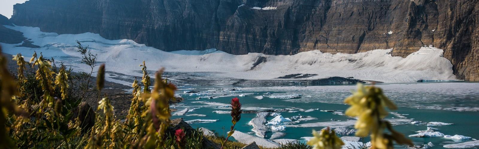

Ready to explore Grinnell Glacier? Here's everything you need to know before you go!
Discover the trail
Oh no! We don't have any photos 😢
This trail hasn't been captured yet. Be the first to share your adventure!Trail description
The Grinnell Glacier trail stands as one of Glacier National Park's most rewarding and accessible glacier viewing experiences. This spectacular hike takes you through diverse mountain terrain to witness one of the park's most photographed glacial formations, nestled dramatically in a cirque beneath towering peaks.
Trail Experience
The journey begins at the Swiftcurrent Motor Inn area, where you'll follow well-maintained paths that wind through classic Montana wilderness. The trail offers two distinct sections that showcase different aspects of the park's remarkable landscape. Initially, you'll traverse relatively gentle terrain alongside pristine alpine lakes, with the path providing excellent views across the water to surrounding peaks.
As you progress deeper into the backcountry, the character of the hike transforms significantly. The latter portion involves more challenging terrain with steeper grades and rocky sections that require sure footing. This transition from lakeside walking to alpine scrambling gives hikers a comprehensive taste of what makes Glacier National Park's trail system so compelling.
Geological Features
The destination glacier represents a living piece of geological history, carved into the mountainside over thousands of years. The cirque formation surrounding the glacier creates a natural amphitheater of rock walls and cascading waterfalls that change dramatically throughout the hiking season. The glacier itself has retreated significantly over recent decades, making it a powerful example of ongoing environmental changes in the Northern Rockies.
The rock formations along the trail showcase the distinctive geology of the region, with colorful sedimentary layers visible in the cliff faces and exposed bedrock. These formations tell the story of ancient sea beds and geological upheaval that created the dramatic landscape hikers experience today.
Wildlife and Ecosystem
The trail passes through multiple ecological zones, each supporting different plant and animal communities. The lower elevations feature dense forest environments, while higher sections transition into alpine meadows and rocky terrain. Mountain goats frequently appear on the cliffs above the glacier, often providing excellent wildlife viewing opportunities for patient hikers.
Bears inhabit the area, making proper food storage and awareness essential for all visitors. The diverse habitat also supports numerous bird species, from forest dwellers in the lower sections to high-altitude specialists near the glacier itself.
Seasonal Considerations
Snow typically blocks access to the upper portions of the trail well into summer, with full accessibility usually not available until mid to late July. Even during peak season, hikers should be prepared for rapidly changing weather conditions, including the possibility of snow at higher elevations.
The optimal hiking window generally extends from late July through September, when the trail is most accessible and weather conditions are most stable. Early season hikers may encounter significant snow patches and potentially dangerous conditions on the steeper sections near the glacier.
Trail Logistics
The trailhead area provides adequate parking, though spaces fill quickly during peak summer months. Early morning starts are strongly recommended both for parking availability and to experience the trail before afternoon weather patterns develop.
Water sources exist along the route, but all water should be treated before consumption. The trail is well-marked throughout, though the upper sections require careful navigation across rocky terrain where the path may be less obvious.
What Sets This Trail Apart
Unlike many glacier viewing opportunities that require technical climbing or extremely long approaches, this trail provides relatively accessible access to an active glacial environment. The combination of lake views, diverse terrain, and the dramatic glacier destination creates a hiking experience that captures the essence of Glacier National Park in a single outing.
The photographic opportunities along this route are exceptional, with the glacier itself providing a stunning backdrop against the surrounding peaks. The changing perspectives as you approach the glacier create multiple viewpoints, each offering unique compositions for photographers and memorable vistas for all hikers.
The trail also serves as an excellent introduction to the park's high country for hikers who may not be ready for more technical alpine routes, while still providing enough challenge and reward to satisfy experienced mountain travelers.
The Essential Hiking Checklist
Everything you need for your next hike. Bilingual, printable, 1 page.
Get your free hiking checklistRecommended gear for this trail
As an Amazon Associate I earn from qualifying purchases.


Ready to go?
Everything you need to know before you goWhen?
How much?
As an Amazon Associate I earn from qualifying purchases.
Affiliate links — LGPO may earn a commission at no extra cost to you.
- Hiking shoes Essential
- → Salomon Elixir Tour Mid WP · 203.38 $
- Layered clothing Essential
- Rain jacket Essential
- Trekking poles
- → Black Diamond Trail Ergo Cork · 69.99 $
- Headlamp
- → Petzl Actik Core 625 · 103.95 $
FAQ - Frequently asked questions
Everything you need to knowSimilar hikes nearby
Discover other trails you might enjoy
Cleveland Mountain
Glacier Country

Northwest Peak
Glacier Country
Kootenai River
Glacier Country
Wire Trail
Glacier Country
Goat Haunt
Glacier Country
Mt. Gould
Glacier Country
Hiking near Calgary
120 trails to explore ~252 km away
We work hard to provide the most up-to-date and error-free data possible. If something seems incorrect, let us know! Your contribution helps the whole community.
Hikers' opinions
Be the first to review!
No hiker has shared their experience yet. Share your impressions and help other hikers!