
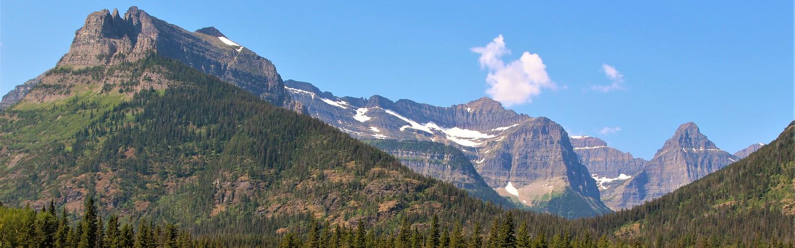

Ready to explore Goat Haunt? Here's everything you need to know before you go!
Discover the trail
Oh no! We don't have any photos 😢
This trail hasn't been captured yet. Be the first to share your adventure!Trail description
Goat Haunt is one of those places that feels genuinely remote — and in many ways, it is. Tucked at the southern end of Waterton Lake, this backcountry destination sits at the northern edge of Glacier National Park in Montana, but it's most commonly accessed by hikers coming from the Canadian side through Waterton Lakes National Park in Alberta. The crossing itself is part of the experience: most visitors arrive by boat across Upper Waterton Lake, stepping off into a landscape that feels worlds away from the trailhead parking lots they left behind.
The area sits within the Crown of the Continent ecosystem, a massive interconnected wilderness shared between Canada and the United States. That ecological context matters here — Goat Haunt isn't just a trailhead, it's a gateway into one of the most intact mountain ecosystems in North America. The wildlife reflects that. Grizzly bears, black bears, mountain goats, moose, and wolves all move through this corridor regularly.
Getting There
The standard approach from the Alberta side is via the Waterton Shoreline Cruise, which runs seasonally from Waterton townsite across Upper Waterton Lake to the Goat Haunt ranger station. This is the most practical way to reach the area without committing to a very long overland route. Because you're crossing an international border, there are entry requirements to be aware of — hikers need to check current customs and border protocols before making the trip, as requirements have changed over the years and can vary by season.
Hikers arriving from Waterton should confirm boat schedules and availability in advance, especially during peak summer months when spots fill up quickly.
The Terrain
Goat Haunt sits at the confluence of several drainages, surrounded by steep, heavily forested slopes that give way to open subalpine terrain and exposed ridgelines higher up. The valley bottom is lush — thick with cottonwoods, willows, and dense undergrowth that provides excellent habitat for wildlife. The transition from the lake's edge into the surrounding backcountry is abrupt and dramatic, with the mountains rising sharply on all sides.
The landscape here is classic front range terrain: limestone peaks, hanging valleys, and the kind of raw, unpolished scenery that doesn't need a viewpoint sign to tell you it's worth stopping for. Upper Waterton Lake itself is the longest lake in the Canadian Rockies, and looking back across it from Goat Haunt gives you a perspective on the scale of this place that's hard to get anywhere else.
Trails and Exploration
Goat Haunt functions primarily as a hub for backcountry travel rather than a day-hike destination on its own. Several trails branch out from the ranger station area, leading deeper into Glacier National Park's backcountry. These routes vary in length and difficulty, and many connect to multi-day loop options for experienced backpackers.
Some of the more notable routes accessible from Goat Haunt include:
- Goat Haunt Overlook Trail — A shorter hike that gains elevation quickly and rewards with views back over Upper Waterton Lake and the surrounding peaks.
- Kootenai Lakes Trail — A relatively flat route through prime wildlife habitat, following the valley bottom to a series of backcountry lakes. Moose sightings are common here.
- Lake Francis and Goat Haunt Lake — Quieter destinations that see less traffic and offer a more solitary backcountry experience.
- Waterton Valley Trail — A longer corridor route that connects Goat Haunt to other parts of the Glacier backcountry for those doing multi-day trips.
Because Goat Haunt is within Glacier National Park (U.S.), all overnight stays require a valid backcountry permit from Glacier. Day hikers arriving by boat from Waterton should confirm current regulations regarding how far they can travel without triggering permit requirements.
Wildlife
This is genuinely one of the better areas in the region for wildlife encounters, and not in a casual, "you might see a deer" kind of way. The dense valley habitat and the relative lack of road access means animals move through here with less disturbance than in more accessible areas. Bear activity is significant — both grizzly and black bears are present, and bear spray is not optional here. Travel in groups, make noise on the trail, and know what to do if you have an encounter.
Mountain goats are frequently spotted on the cliffs above the valley. Bald eagles and osprey work the lake. The Kootenai Lakes area in particular is known for moose, which are often visible in and around the wetlands.
Practical Considerations
- Border crossing: Goat Haunt is in the United States. Hikers coming from Waterton are crossing an international border. Check current entry requirements well before your trip — documentation requirements apply even for day hikers arriving by boat.
- Boat access: The Waterton Shoreline Cruise operates seasonally. Confirm current schedules and book ahead during summer.
- Bear country protocols: Bear spray is strongly recommended and should be carried accessible, not buried in a pack. Food storage regulations apply in the backcountry.
- Permits: Overnight backcountry camping within Glacier National Park requires a permit obtained through the U.S. National Park Service. Day use from the boat landing has its own set of rules — verify these before you go.
- Weather: Mountain weather in this area changes fast. Even on a clear morning in Waterton, conditions at Goat Haunt can shift significantly. Bring layers and rain gear regardless of the forecast.
- No road access: There is no road to Goat Haunt. The boat is the practical option for most visitors coming from the Alberta side. This also means if you miss the last boat back, you're committing to a very long walk or an unplanned overnight.
What Makes This Place Worth It
Goat Haunt earns its reputation not through manicured trails or interpretive signs, but through the simple fact that it's hard to get to and genuinely wild once you're there. The combination of the lake crossing, the international border, the dense wildlife habitat, and the access to serious backcountry terrain makes it a destination that stands apart from most of what's accessible in the Waterton-Glacier region. If you're comfortable in bear country, have your paperwork sorted, and don't mind a bit of logistical planning, it delivers the kind of experience that's increasingly rare in heavily visited national parks.
The Essential Hiking Checklist
Everything you need for your next hike. Bilingual, printable, 1 page.
Get your free hiking checklistRecommended gear for this trail
As an Amazon Associate I earn from qualifying purchases.


Ready to go?
Everything you need to know before you goWhen?
How much?
As an Amazon Associate I earn from qualifying purchases.
Affiliate links — LGPO may earn a commission at no extra cost to you.
- Hiking shoes Essential
- → Salomon Elixir Tour Mid WP · 203.38 $
- Layered clothing Essential
- Rain jacket Essential
- Trekking poles
- → Black Diamond Trail Ergo Cork · 69.99 $
- Headlamp
- → Petzl Actik Core 625 · 103.95 $
FAQ - Frequently asked questions
Everything you need to knowSimilar hikes nearby
Discover other trails you might enjoy
Cleveland Mountain
Glacier Country

Northwest Peak
Glacier Country
Kootenai River
Glacier Country
Wire Trail
Glacier Country
Grinnell Glacier
Glacier Country
Mt. Gould
Glacier Country
Hiking near Calgary
120 trails to explore ~232 km away
We work hard to provide the most up-to-date and error-free data possible. If something seems incorrect, let us know! Your contribution helps the whole community.
Hikers' opinions
Be the first to review!
No hiker has shared their experience yet. Share your impressions and help other hikers!