

Ready to explore Bertha Lake? Here's everything you need to know before you go!
Discover the trail
Oh no! We don't have any photos 😢
This trail hasn't been captured yet. Be the first to share your adventure!Trail description
Description
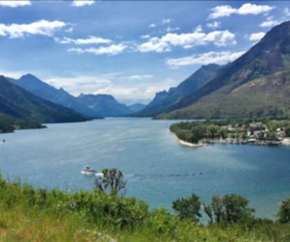
Bertha Lake sits tucked into the mountains of Waterton Lakes National Park, offering one of the most rewarding day hikes in the Canadian Rockies. This turquoise alpine lake draws hikers with its combination of accessible trail conditions, diverse scenery, and the kind of mountain views that make the effort worthwhile.
The Trail Experience
The Bertha Lake Trail covers 5.7 kilometers one-way with 150 meters of elevation gain, making it an easy hike that most people can tackle comfortably. The gentle grade and well-maintained path make this an excellent choice for families or anyone looking to experience alpine beauty without technical challenges. The trailhead begins right from Waterton townsite, making logistics simple—no long drives to remote parking areas.
The path starts by winding through dense montane forest where Douglas fir and aspen create a canopy overhead. Early sections follow Bertha Creek, and you'll hear the water long before catching glimpses through the trees. The trail is well-marked throughout, with wooden bridges crossing creek sections and clear signage at key junctions.
About halfway up, the forest opens to reveal Bertha Falls, a multi-tiered cascade that provides both a natural rest stop and photo opportunity. The sound of rushing water accompanies much of the lower trail, creating a soundtrack that many hikers find more pleasant than the silence of some alpine routes.
As you gain elevation gradually, the forest transitions and views begin opening toward the surrounding peaks. The final approach to the lake maintains the easy grade, with well-constructed switchbacks managing what little climb exists. The anticipation builds as you catch glimpses of the lake's distinctive blue-green color through the trees.
At the Lake
Bertha Lake itself justifies every step of the journey. The water displays that characteristic turquoise color found in glacial-fed alpine lakes, created by fine rock particles suspended in the water. Towering peaks frame the far shore, creating natural amphitheater walls that rise dramatically from the water's edge.
The shoreline offers several spots perfect for rest stops or picnicking. Large rocks provide natural seating, and the relatively sheltered position means the lake area often feels calmer than the exposed ridges above. On clear days, the mountain reflections in the still water create mirror images that look almost too perfect to be real.
For those wanting to extend their time at the lake, an informal trail continues along the eastern shore. This path doesn't lead to another major destination, but it provides different vantage points and a bit more solitude for those willing to explore beyond the main arrival area. The easy terrain makes this exploration accessible to anyone who made it to the lake.
Wildlife and Natural Features
The Bertha Lake area supports diverse wildlife typical of the Canadian Rockies ecosystem. Deer frequently appear along the lower sections of trail, particularly in early morning or evening hours. Mountain goats inhabit the higher elevations around the lake, though sightings require patience and sharp eyes—they blend remarkably well with the rocky terrain.
Bird watchers will find varied species throughout the elevation zones. The forested sections host typical woodland birds, while the alpine areas near the lake attract species adapted to higher elevations. The transition zones often provide the most diverse viewing opportunities as different habitats meet.
Always maintain appropriate distances from any wildlife encountered. The animals in this area are wild, and their behavior can be unpredictable. Carry bear spray as a standard precaution, though encounters remain relatively uncommon on this well-traveled trail.
Seasonal Considerations and Planning
The trail typically becomes accessible sometime in late spring, though snow can linger in shaded sections and around the lake well into early summer. Fall hiking offers excellent conditions with fewer crowds and the added bonus of changing aspen colors in the lower elevations. The easy grade means this trail remains accessible longer into the season than more challenging alpine routes.
Weather in the mountains changes quickly, so prepare for conditions beyond what you observe at the trailhead. The lake sits at higher elevation than Waterton townsite, and temperatures can be notably cooler. Wind is common around the lake itself, making an extra layer valuable even on warm days.
Water sources exist along the trail, but treat any natural water before drinking. Many hikers prefer carrying sufficient water for the entire trip rather than dealing with purification on the trail, especially given the easy nature of the hike makes carrying extra water manageable.
Essential Gear and Preparation
Good hiking shoes provide the foundation for a comfortable trip, though the easy terrain doesn't demand heavy boots. The trail includes some rocky sections, root-covered areas, and potentially muddy spots near creek crossings, but nothing that requires specialized footwear.
Weather-appropriate clothing means layers you can adjust as conditions change. The forested lower sections often feel warmer and more humid, while the lake area can be surprisingly cool and windy. A waterproof layer protects against sudden mountain weather changes that can happen even on clear days.
Carry plenty of water and snacks to enhance your time at the lake. The easy grade means you won't be exhausted, making the lakeside stop more enjoyable for relaxing and taking in the scenery. Plan for the full 3.5-hour duration to truly appreciate what this accessible alpine gem has to offer.
Check current park regulations and trail conditions before departing. Waterton Lakes National Park maintains updated information about trail status, wildlife activity, and any temporary restrictions that might affect your plans.
Recommended gear for this trail


Ready to go?
Everything you need to know before you goStarting Point
The start of the trails at the bertha lake can be accessed by travelling east on Highway 11 from Edmonton. The trailhead is located approximately 30 kilometres east of Edmonton, just past the hamlet of Ranfurly.
When?
How much?
- Hiking shoes Essential
- → Salomon Elixir Tour Mid WP · 203.38 $
- Layered clothing Essential
- Rain jacket Essential
- Trekking poles
- → Black Diamond Trail Ergo Cork · 69.99 $
- Headlamp
- → Petzl Actik Core 625 · 103.95 $
FAQ - Frequently asked questions
Everything you need to knowThe Essential Hiking Checklist
Everything you need for your next hike. Bilingual, printable, 1 page.
Download the free checklistSimilar hikes nearby
Discover other trails you might enjoy

Crypt Lake Trail
Southern Rockies
Waterton Lakes National Park of Canada
Southern Rockies

Lundbreck Falls
Southern Rockies

Castle Mountain Resort
Southern Rockies
Blakiston Falls
Southern Rockies
Lower Bertha Falls
Southern Rockies
Hiking near Calgary
120 trails to explore ~225 km away
We work hard to provide the most up-to-date and error-free data possible. If something seems incorrect, let us know! Your contribution helps the whole community.
Hikers' opinions