

Ready to explore Crypt Lake Trail? Here's everything you need to know before you go!
Discover the trail
Oh no! We don't have any photos 😢
This trail hasn't been captured yet. Be the first to share your adventure!Trail description
Description
Crypt Lake Trail earns its reputation as one of the most adventurous hikes in Waterton Lakes National Park — and honestly, in all of Alberta. It's not just the destination that makes it memorable. It's the whole sequence of events that gets you there: a boat ride, a tunnel through solid rock, a steel cable traverse, a ladder. This trail delivers a genuinely different kind of day in the mountains.
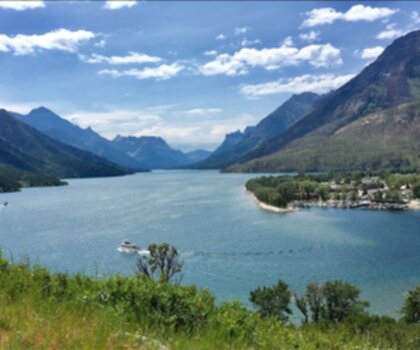
The adventure starts before you take a single step on dirt. The trailhead is only accessible by boat across Waterton Lake, which immediately shifts your mindset. You're not pulling into a parking lot and hitting a well-worn path — you're crossing open water to reach a remote dock on the far shore. That boat ride sets the tone for everything that follows.
Getting Into It: The Lower Trail
From the dock, the trail follows Crypt Creek up through dense montane forest. The climbing starts right away and stays consistent — this isn't a trail that eases you in gently. The path is well-maintained, but the elevation gain is real and cumulative. Early on, you'll pass several waterfalls where Crypt Creek drops over rock ledges. These make natural stopping points, and the mist keeps things cool even on warm days. The rock surfaces near these falls can be slippery, so watch your footing.
As you gain elevation, the forest thins and the terrain opens up. The views start to build, and you begin to get a sense of the scale of what's ahead. The trail transitions from packed dirt to rocky switchbacks, and the character of the hike shifts noticeably.
The Technical Sections
This is what most people come for, and it doesn't disappoint. As the trail approaches the headwall below Crypt Lake, you hit three features in sequence that you won't find on most hikes in the Canadian Rockies:
- Steel cable traverse: A narrow ledge section with significant exposure. You move along the cliff face with the cable as your handhold. It's not technical climbing, but it demands focus and comfort with heights.
- Rock tunnel: Blasted through solid limestone, this short passage requires you to get down on hands and knees and crawl through. It's tight, it's dark, and it's genuinely fun.
- Steel ladder: A brief but steep section that requires basic upper body strength. If you're carrying a large pack, this is where you'll feel it.
These aren't obstacles for the sake of drama — they're the only practical way to navigate terrain that would otherwise shut most hikers out. Each one is short, but together they create a sequence that demands your full attention. Anyone uncomfortable with heights or confined spaces should think carefully before committing to this trail.
The Cirque and the Lake
Once you clear the technical sections, the trail opens into the cirque that holds Crypt Lake. The shift is immediate and striking. You go from navigating cliff faces to standing in a wide alpine bowl surrounded by near-vertical limestone walls. The lake sits at the base of those cliffs, crystal clear, with the international border running directly through the water. On the right day, small icebergs float on the surface well into summer, pushed into the shadowed corners of the cirque where snow lingers long after the lower trail has dried out.
The setting is remote in a way that feels earned. The combination of boat access and the technical headwall keeps casual traffic down, and the cirque has a stillness to it that's hard to find on more accessible trails.
Terrain and Conditions
The trail covers a wide range of terrain over its 44 kilometres, with 1,200 metres of elevation gain. You move through forest understory, rocky switchbacks, loose scree, carved cliff-face trail, and finally open alpine. Each zone has its own demands and its own rewards.
Weather changes fast at this elevation. Morning starts can be clear and calm while afternoon brings thunderstorms or a sharp temperature drop. The microclimate around the lake runs cooler and windier than the lower trail, and the shadowed sections of the cirque hold snow and ice well into the season. Early season hikers should expect snow patches near the lake. Late season visitors need to account for potentially icy conditions on the cable and ladder sections — those features become significantly more serious when wet or frozen.
Stream crossings are limited but can be tricky during spring runoff or after heavy rain. The consistently moist conditions near the waterfalls keep nearby rock surfaces slick, so poles are useful even if you don't normally use them.
Planning the Hike
With 44 kilometres and 1,200 metres of gain, this trail is rated hard and typically takes 2 to 3 days to complete properly. The technical sections add a layer of complexity that goes beyond simple fitness — you need to be comfortable with exposure, confined spaces, and basic ladder climbing with a loaded pack.
The boat schedule is non-negotiable in your planning. Missing the last boat back means an unplanned overnight or a significantly longer alternate route. Check current schedules with the park before you go and build real buffer time into your day. The boat operates seasonally, generally from late June through early September, weather permitting. The trail itself is typically accessible from late June through September, though snowpack varies year to year.
Gear-wise, sturdy hiking boots with solid ankle support are essential — the loose rock, steep grades, and wet sections near the falls will punish anything less. Bring more water than you think you need; the sustained elevation gain and exposure are dehydrating, and reliable water sources along the route are limited. Layers are mandatory, including rain protection and something warm for the alpine environment around the lake.
Wildlife and the International Border
The elevation gradient along this trail supports a genuine variety of wildlife. Mountain goats are frequently spotted on the cliffs above the headwall. Black bears are present in the forested lower sections. Alpine bird species are common around the lake. The transition through multiple habitat zones in a single hike creates real opportunities for wildlife encounters throughout the day.
The international border adds a detail that's easy to overlook until you're standing at the lake: the boundary between Canada and the United States runs directly through Crypt Lake. You can cross from Alberta into Montana and back in the same afternoon, which is a strange and memorable thing to experience in the middle of a wilderness cirque.
For photographers, the range of subjects along this trail is exceptional — from the boat crossing and the waterfall sections to the technical headwall and the dramatic alpine bowl at the end. The light in the cirque in the morning, before the cliffs cast their shadows across the water, is worth the early start on its own.
Recommended gear for this trail


Ready to go?
Everything you need to know before you goStarting Point
The crypt lake trail is located in Waterton Lakes National Park, Alberta. The nearest town is Waterton Park, Alberta.
When?
How much?
- Hiking shoes Essential
- → Salomon Elixir Tour Mid WP · 203.38 $
- Layered clothing Essential
- Rain jacket Essential
- Trekking poles
- → Black Diamond Trail Ergo Cork · 69.99 $
- Headlamp
- → Petzl Actik Core 625 · 103.95 $
FAQ - Frequently asked questions
Everything you need to knowThe Essential Hiking Checklist
Everything you need for your next hike. Bilingual, printable, 1 page.
Download the free checklistSimilar hikes nearby
Discover other trails you might enjoy
Waterton Lakes National Park of Canada
Southern Rockies

Blakiston Falls
Southern Rockies

Castle Mountain Resort
Southern Rockies

Lundbreck Falls
Southern Rockies
Lower Bertha Falls
Southern Rockies
Crowsnest Mountain
Southern Rockies
Hiking near Calgary
120 trails to explore ~228 km away
We work hard to provide the most up-to-date and error-free data possible. If something seems incorrect, let us know! Your contribution helps the whole community.
Hikers' opinions
Be the first to review!
No hiker has shared their experience yet. Share your impressions and help other hikers!