

Ready to explore Lundbreck Falls? Here's everything you need to know before you go!
Discover the trail
Trail description
Description
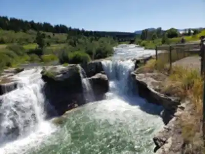
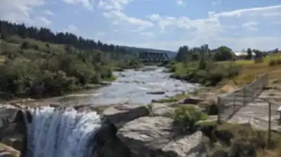
Lundbreck Falls delivers one of southern Alberta's most accessible waterfall experiences, where the Crowsnest River plunges 12 meters (40 feet) over limestone ledges in a thunderous display that can be heard from the parking area. Located just off Highway 3 near the hamlet of Lundbreck, this natural attraction sits perfectly positioned for travelers exploring the foothills region of the Canadian Rockies, offering a rewarding outdoor experience without the commitment of a backcountry expedition.
The 5.6-kilometer trail system around Lundbreck Falls caters to hikers seeking an easy outing with minimal elevation gain of just 12 meters, making it suitable for families, casual walkers, and anyone looking to stretch their legs during a road trip. The well-maintained paths wind along the Crowsnest River both upstream and downstream from the main falls, providing multiple perspectives of this impressive cascade and the surrounding limestone canyon.
The Trail Experience
Your visit begins at the easily accessible parking area just steps from Highway 3. The main viewing area requires only a short walk from your vehicle, but the real rewards come from exploring the network of riverside trails that extend in both directions from the falls. The terrain consists primarily of packed earth and rocky sections, with some root-covered areas near the water's edge that can become slippery when wet.
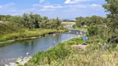
The trail downstream from the falls follows the river through a mixed forest of aspen, poplar, and spruce, offering glimpses of the water rushing through narrow channels carved into the bedrock. Upstream, the path becomes more rugged as it traces the river's edge, leading to quieter pools and smaller cascades that provide excellent spots for photography and contemplation.
Plan for approximately two hours to fully explore the trail system, though you could easily spend longer if you're interested in photography or simply want to soak in the atmosphere. The relatively flat terrain means you'll cover ground quickly, but the numerous viewpoints and photo opportunities naturally slow your pace.
Photography and Viewpoints
Lundbreck Falls offers exceptional photography opportunities throughout the trail system. The main falls can be captured from multiple angles, including a dramatic head-on view from the base and elevated perspectives from the rocky outcrops above. The limestone canyon walls create natural frames for compositions, while the varying water levels throughout the seasons provide different moods and textures.
Early morning and late afternoon light work particularly well here, as the sun angles create interesting shadows and highlights on the water and rock faces. The mist generated by the falls adds atmospheric elements to photos, especially during cooler weather when the vapor becomes more pronounced.
Facilities and Amenities
Designated picnic areas near the falls provide tables and basic facilities where you can enjoy a meal while listening to the constant sound of cascading water. These spots work well for families or groups wanting to combine hiking with a relaxed outdoor meal. The picnic areas offer partial shade and are positioned to take advantage of views toward the river and surrounding forest.
The proximity to Highway 3 means you're never far from services in nearby communities, but it's worth bringing water and snacks to fully enjoy your time at the falls without needing to cut your visit short.
Wildlife and Natural Features
The diverse ecosystem around Lundbreck Falls supports a variety of wildlife that visitors frequently encounter. White-tailed deer are commonly spotted along the trails, particularly during early morning and evening hours. The area's bird population includes eagles soaring overhead and various songbirds in the forest canopy.
Black bears inhabit the region, so maintain awareness of your surroundings and make noise while hiking, especially in areas with dense vegetation near the water. Store food properly and never approach or feed any wildlife you encounter. The bears in this area are typically focused on natural food sources, but proper precautions ensure safe coexistence.
The limestone geology creates interesting rock formations throughout the area, with layers visible in the canyon walls that tell the story of ancient sea beds and geological processes. The river has carved intricate patterns in the bedrock, creating pools, channels, and smaller waterfalls that add visual interest beyond the main cascade.
Seasonal Considerations
Lundbreck Falls remains accessible year-round, with each season offering distinct advantages for visitors. Spring brings high water levels from snowmelt, making the falls particularly powerful and dramatic. The surrounding vegetation emerges in fresh greens, and wildflowers begin appearing along the trail edges.
Summer provides the most comfortable hiking conditions, with warm temperatures perfect for spending extended time outdoors. The full canopy offers shade along portions of the trail, and the lower water levels reveal more of the interesting rock formations in the riverbed.
Autumn transforms the area with vibrant foliage as aspen and poplar trees turn golden yellow, creating stunning contrasts against the dark evergreens and limestone cliffs. This season often provides the clearest photography conditions with crisp air and excellent visibility.
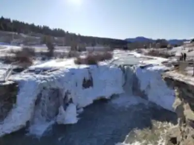
Winter visits offer a completely different experience, as ice formations develop around the falls and along the river edges. The snow-covered landscape creates a serene atmosphere, though visitors should exercise extra caution on potentially icy trail surfaces and dress appropriately for cold conditions.
The falls' location in the foothills region means weather can change quickly regardless of season, so layered clothing and basic rain protection are always wise choices for ensuring a comfortable visit.
Recommended gear for this trail


Ready to go?
Everything you need to know before you goStarting Point
The lundbreck falls are located in the Crowsnest Pass, Alberta. To get to the start of the trails, take Highway 3 east from Calgary to the Crowsnest Pass. The falls are located on the north side of the highway, just west of Lundbreck.
When?
How much?
- Hiking shoes Essential
- → Salomon Elixir Tour Mid WP · 203.38 $
- Layered clothing Essential
- Rain jacket Essential
- Trekking poles
- → Black Diamond Trail Ergo Cork · 69.99 $
- Headlamp
- → Petzl Actik Core 625 · 103.95 $
FAQ - Frequently asked questions
Everything you need to knowThe Essential Hiking Checklist
Everything you need for your next hike. Bilingual, printable, 1 page.
Download the free checklistSimilar hikes nearby
Discover other trails you might enjoy

Crypt Lake Trail
Southern Rockies
Waterton Lakes National Park of Canada
Southern Rockies

Castle Mountain Resort
Southern Rockies
Blakiston Falls
Southern Rockies
Lower Bertha Falls
Southern Rockies
Crowsnest Mountain
Southern Rockies
Hiking near Calgary
120 trails to explore ~163 km away
We work hard to provide the most up-to-date and error-free data possible. If something seems incorrect, let us know! Your contribution helps the whole community.
Hikers' opinions