
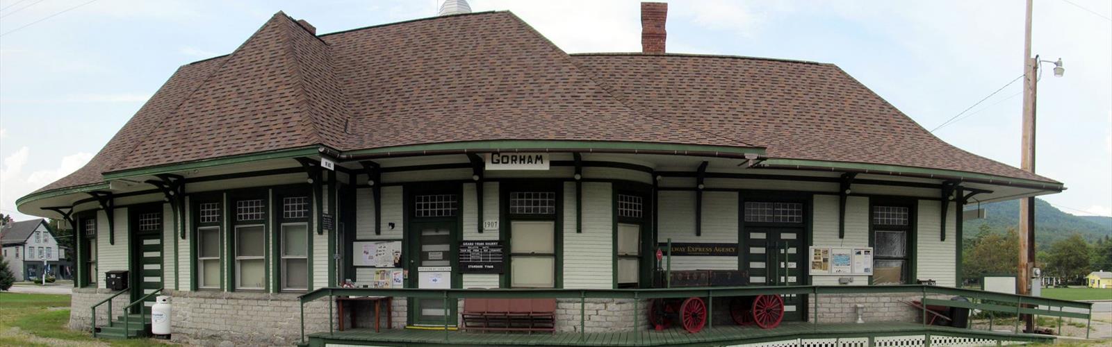

Ready to explore Carter-Moriah Trail head (Bangor Street)? Here's everything you need to know before you go!
Discover the trail
Oh no! We don't have any photos 😢
This trail hasn't been captured yet. Be the first to share your adventure!Trail description
The Carter-Moriah Trailhead on Bangor Street in Gorham, New Hampshire, serves as your entry point into one of the White Mountains' most rewarding hiking experiences. This trailhead sits at the base of what becomes a challenging climb to Mount Moriah, offering hikers access to some of the region's most spectacular high-elevation views without the crowds found on more popular peaks.
Located right in Gorham, the trailhead provides convenient access to the Carter-Moriah Trail system, which forms part of the Appalachian Trail corridor through this section of the White Mountains. The positioning makes it an ideal starting point for both day hikers looking to tackle Mount Moriah and through-hikers working their way along the AT's challenging New Hampshire section.
The Trail Experience
From the Bangor Street trailhead, the Carter-Moriah Trail immediately establishes its character as a serious mountain hike. The path begins in dense mixed forest typical of the White Mountains' lower elevations, where you'll walk among towering white pines, maples, and birches that create a stunning canopy overhead. During fall months, this forest transforms into an explosion of reds, oranges, and golds that rivals any foliage display in New England.
As you gain elevation, the forest composition gradually shifts. The deciduous trees give way to more conifers, and the understory becomes increasingly sparse. This transition marks your entry into the montane zone, where the real work of the climb begins. The trail becomes steeper and more technical, requiring careful foot placement on rocky sections and occasional scrambles over granite ledges.
The path to Mount Moriah demands respect. This isn't a casual walk in the woods—it's a legitimate mountain climb that will test your endurance and hiking skills. The trail gains significant elevation over its course, with several steep pitches that will have you breathing hard and grateful for rest breaks. Rocky sections require attention to footing, especially when wet, and the trail can be muddy and slippery during spring snowmelt or after heavy rains.
Wildlife and Natural Features
The Carter-Moriah Trail corridor supports diverse wildlife populations that change with elevation and season. In the lower forests, you might encounter white-tailed deer, red squirrels, and various songbird species. Black bears inhabit these woods, though sightings are relatively uncommon. As you climb higher, watch for signs of moose, which frequent the area, particularly in early morning and evening hours.
Birdwatchers will find plenty to observe, from common forest species like chickadees and nuthatches in the lower elevations to specialized high-elevation birds near the summit. The changing forest zones create distinct habitats that support different species throughout your climb.
The geological features along the trail tell the story of the White Mountains' formation. Granite outcroppings become more frequent as you climb, offering glimpses of the massive plutonic intrusions that form the backbone of this mountain range. These rock formations also provide natural viewpoints and rest spots during your ascent.
Summit Rewards
Mount Moriah's summit delivers on the promise that drives hikers up its challenging slopes. The panoramic views from the top encompass the entire Presidential Range, with Mount Washington's distinctive profile dominating the western horizon. On clear days, you can trace the ridgeline from Madison through Adams, Jefferson, and Washington, with the Northern Presidentials extending beyond.
The summit offers a 360-degree perspective that includes views into Maine's western mountains and Vermont's Green Mountains on exceptionally clear days. The Carter Range extends to the north, while the Pilot Range fills the eastern view. This vantage point provides one of the best opportunities to understand the geography and scale of the White Mountains region.
The summit area itself features open ledges and scattered low vegetation typical of White Mountain peaks. The exposure means weather conditions can change rapidly, and temperatures are typically 10-15 degrees cooler than at the trailhead. Wind is common and can be significant, especially during shoulder seasons.
Planning Your Hike
A hike to Mount Moriah from the Bangor Street trailhead typically requires 6 to 8 hours for most hikers, depending on fitness level, weather conditions, and time spent enjoying the summit views. This timeframe includes breaks for rest, food, and photography, making it a full day commitment.
Water requirements are significant for this hike. Carry at least two liters per person, and consider bringing a water filter if you're familiar with reliable water sources along the route. The physical demands of the climb, combined with potential heat and sun exposure, make proper hydration critical for safety and enjoyment.
Weather in the White Mountains changes rapidly and can be dramatically different between the trailhead and summit. Even on warm summer days, temperatures on Mount Moriah can be surprisingly cool, and afternoon thunderstorms develop quickly. Pack layers including a warm hat, gloves, and rain gear regardless of the forecast. Wind-resistant outer layers are particularly important given the exposed nature of the summit.
Proper footwear makes a significant difference on this trail. Sturdy hiking boots with good ankle support and aggressive tread are recommended for the rocky sections and steep terrain. Trekking poles can be valuable for stability during the descent, when loose rocks and steep grades challenge even experienced hikers.
The trail can be hiked year-round, but conditions vary dramatically by season. Summer offers the most predictable weather but also the highest traffic. Fall provides spectacular foliage but requires extra caution on wet leaves covering rocky sections. Winter hiking demands mountaineering skills, proper equipment including microspikes or snowshoes, and experience with White Mountain winter conditions.
The Essential Hiking Checklist
Everything you need for your next hike. Bilingual, printable, 1 page.
Get your free hiking checklistRecommended gear for this trail
As an Amazon Associate I earn from qualifying purchases.


Ready to go?
Everything you need to know before you goStarting Point
To reach the trailhead, head to Bangor Street in Gorham. The parking area for the trail is located at the end of Bangor Street.
When?
How much?
As an Amazon Associate I earn from qualifying purchases.
Affiliate links — LGPO may earn a commission at no extra cost to you.
- Hiking shoes Essential
- → Salomon Elixir Tour Mid WP · 203.38 $
- Layered clothing Essential
- Rain jacket Essential
- Trekking poles
- → Black Diamond Trail Ergo Cork · 69.99 $
- Headlamp
- → Petzl Actik Core 625 · 103.95 $
FAQ - Frequently asked questions
Everything you need to knowSimilar hikes nearby
Discover other trails you might enjoy
Lake Francis
Great North Woods
Alpine Cascades
Great North Woods
Jericho Mountain State Park
Great North Woods
Umbagog Lake State Park
Great North Woods

Milan Hill State Park
Great North Woods
Mt Cabot
Great North Woods
Hiking near North Conway
0 trails to explore ~37 km away
We work hard to provide the most up-to-date and error-free data possible. If something seems incorrect, let us know! Your contribution helps the whole community.
Hikers' opinions
Be the first to review!
No hiker has shared their experience yet. Share your impressions and help other hikers!