

Ready to explore Truchas Peak, New Mexico? Here's everything you need to know before you go!
Discover the trail


Trail description
Truchas Peak stands as one of the most rewarding high-altitude destinations in New Mexico. Rising to become the second-highest summit in the state, this peak in the Sangre de Cristo Mountains draws hikers who are serious about earning their views. The approach takes you through some of the most dramatic alpine terrain in the Southwest — think open tundra, rocky ridgelines, and sweeping vistas that stretch across northern New Mexico on a clear day.
The Terrain
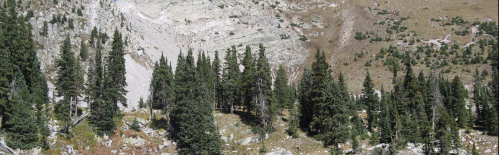
The Sangre de Cristo range here is rugged and unforgiving in the best possible way. The trail to Truchas Peak climbs through dense conifer forest before breaking out into open alpine zones where the treeline gives way to exposed rock and high-altitude meadows. The upper reaches of the route are rocky and require solid footing — this isn't a casual stroll, and the final push to the summit involves scrambling over loose talus and boulders.
The peak itself is part of a cluster of summits — North Truchas, Middle Truchas, and South Truchas — that form a dramatic ridgeline visible from much of the Rio Grande valley to the west. The views from the top take in the Jemez Mountains, the Taos area to the north, and on exceptionally clear days, much of northern New Mexico's high country.
What to Expect on the Trail
This is a serious mountain objective. The elevation gain is substantial, and the altitude at the summit means you'll be operating in genuinely thin air. If you're coming from lower elevations, give yourself a day or two to acclimatize before attempting the peak — altitude sickness is a real concern up here, and it doesn't care how fit you are.
The trail passes through the Pecos Wilderness, which is part of the Santa Fe National Forest. This is designated wilderness, so the experience feels genuinely remote. You won't find crowds the way you might on more accessible peaks, but you will find solitude, wildlife, and the kind of quiet that only comes with real elevation and real effort.
Weather is the biggest variable on Truchas Peak. Afternoon thunderstorms are a well-known feature of New Mexico summers, and at this altitude, lightning is a serious hazard on the exposed upper ridges. Starting early — well before noon — is not just good practice here, it's essential. If you see storm clouds building over the Sangre de Cristos, get below treeline immediately.
Flora and Wildlife
The climb through different elevation bands means you pass through distinct ecological zones. Lower sections of the approach move through mixed conifer forest dominated by spruce and fir. As you gain elevation, the trees thin and eventually disappear, replaced by alpine grasses, wildflowers in season, and the kind of sparse, wind-sculpted vegetation that survives at high altitude.
Wildlife in the Pecos Wilderness includes black bear, mule deer, and elk. Marmots are common in the talus fields near the summit, and you'll likely hear their sharp warning calls before you see them. Raptors — including hawks and eagles — are frequently spotted riding thermals along the ridgeline.
Access and Trailhead
The most common approach to Truchas Peak begins from the Pecos Wilderness trailhead near the village of Truchas on the High Road to Taos. The High Road itself is a scenic route that connects Santa Fe to Taos through a series of historic mountain villages, and Truchas is one of the most picturesque of these communities. The trailhead access involves driving through private land and a land grant area — pay attention to posted signs and respect private property boundaries.
Parking at the trailhead is limited. Arriving early not only helps you beat afternoon storms but also ensures you get a spot. There are no facilities at the trailhead, so come prepared with everything you need.
Permits and Regulations
The trail passes through the Pecos Wilderness, which is managed by the Santa Fe National Forest. Wilderness regulations apply — no motorized or mechanized equipment, which means no mountain bikes. Leave No Trace principles are expected and enforced. Group size limits apply in designated wilderness areas, so check current regulations with the Santa Fe National Forest before heading out.
No entry fee is required to access the Pecos Wilderness, but if you're camping overnight, be aware of fire restrictions, which can be significant during dry periods in New Mexico.
Gear and Preparation
This hike demands proper preparation. Given the altitude and exposed terrain near the summit, the following are worth having:
- Layers: Temperatures at the summit can be dramatically colder than at the trailhead, even in summer. Wind chill on the exposed ridgeline adds to this.
- Rain gear: Afternoon storms can roll in fast. A lightweight waterproof shell is non-negotiable.
- Trekking poles: Useful on the descent through loose talus and rocky terrain.
- Plenty of water: There are water sources along the route, but treat any backcountry water before drinking.
- Navigation tools: A map and compass or GPS device — the upper mountain can be disorienting in poor visibility.
- Sun protection: At high altitude, UV exposure is intense. Sunscreen, sunglasses, and a hat are essential.
Who This Hike Is For
Truchas Peak is best suited for experienced hikers who are comfortable with sustained elevation gain, off-trail scrambling, and the unpredictability of high-mountain weather. It's not a beginner destination, and the altitude alone will humble hikers who underestimate it. That said, for those with the fitness and experience to take it on, the summit of Truchas Peak delivers one of the most memorable high-country experiences in New Mexico — a genuine wilderness summit with views that put the scale of the Sangre de Cristo range into sharp perspective.
The Essential Hiking Checklist
Everything you need for your next hike. Bilingual, printable, 1 page.
Get your free hiking checklistRecommended gear for this trail
As an Amazon Associate I earn from qualifying purchases.


Ready to go?
Everything you need to know before you goWhen?
How much?
As an Amazon Associate I earn from qualifying purchases.
Affiliate links — LGPO may earn a commission at no extra cost to you.
- Hiking shoes Essential
- → Salomon Elixir Tour Mid WP · 203.38 $
- Layered clothing Essential
- Rain jacket Essential
- Trekking poles
- → Black Diamond Trail Ergo Cork · 69.99 $
- Headlamp
- → Petzl Actik Core 625 · 103.95 $
FAQ - Frequently asked questions
Everything you need to knowSimilar hikes nearby
Discover other trails you might enjoy
Tesuque Peak, New Mexico
North Central New Mexico
Lake Peak, New Mexico
North Central New Mexico
Venado Peak, New Mexico
North Central New Mexico

Santa Fe Baldy
North Central New Mexico
Old Santa Fe Trail
North Central New Mexico
Santa Fe National Historic Trail
North Central New Mexico
Hiking near Brandon
5 trails to explore ~1609 km away
We work hard to provide the most up-to-date and error-free data possible. If something seems incorrect, let us know! Your contribution helps the whole community.
Hikers' opinions
Be the first to review!
No hiker has shared their experience yet. Share your impressions and help other hikers!