
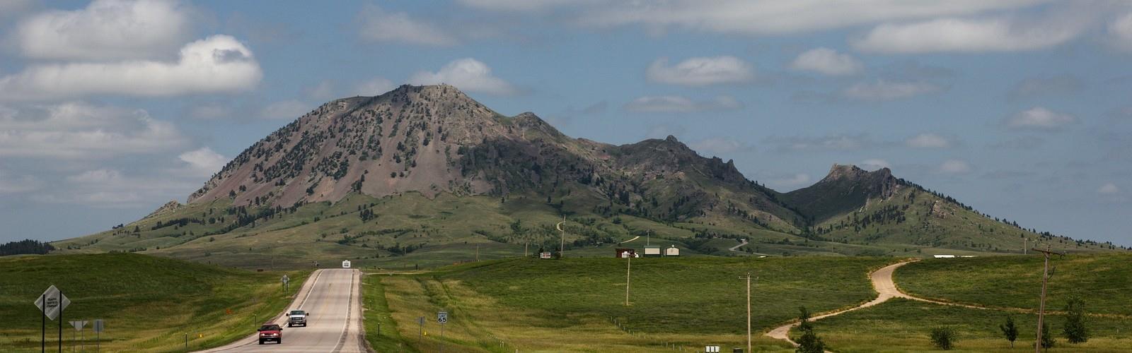

Ready to explore Bear Butte, South Dakota? Here's everything you need to know before you go!
Discover the trail
Oh no! We don't have any photos 😢
This trail hasn't been captured yet. Be the first to share your adventure!Trail description
Bear Butte stands as one of South Dakota's most distinctive and sacred landmarks, rising dramatically from the surrounding plains in the western part of the state. This isolated volcanic formation, known as a laccolith, towers approximately 1,200 feet above the prairie floor, creating an unmistakable silhouette that has served as a navigation point and spiritual destination for centuries.
Sacred Ground and Cultural Significance
Bear Butte holds profound spiritual importance for numerous Native American tribes, including the Lakota, Cheyenne, and other Plains tribes. The mountain is considered one of the most sacred sites in North America, where vision quests, prayer ceremonies, and other traditional practices continue to this day. Visitors will notice prayer cloths and offerings tied to trees along the trails, which should be respected and left undisturbed. The site's cultural significance extends beyond its natural beauty, making it a place where outdoor recreation intersects with living spiritual traditions.
Geological Wonder
The formation of Bear Butte dates back millions of years when molten rock pushed upward through the earth's crust but never reached the surface, creating the distinctive dome-shaped mountain visible today. Over time, erosion stripped away the surrounding sedimentary layers, exposing the harder igneous core. This geological process resulted in the dramatic elevation change that makes Bear Butte such a prominent feature on the landscape. The mountain's unique formation provides hikers with an opportunity to observe geological processes that shaped the region.
Trail Experience
The main hiking trail to the summit winds its way up the mountain through diverse terrain and vegetation zones. Starting from the base, hikers begin in prairie grassland before transitioning into ponderosa pine and oak woodlands as elevation increases. The trail is well-maintained but steep in sections, requiring steady effort and good footing. Along the way, interpretive signs provide information about the area's natural and cultural history.
As you climb higher, the views expand to reveal the surrounding Black Hills to the south and the vast Great Plains stretching in other directions. The contrast between the forested mountain slopes and the open prairie creates a unique hiking environment that showcases the transition between different ecosystems. Wildlife sightings may include white-tailed deer, wild turkeys, and various bird species that inhabit the mountain's diverse habitats.
Summit Views and Rewards
Reaching the summit of Bear Butte provides panoramic views that extend for miles in every direction. On clear days, hikers can see the Black Hills, including Harney Peak, as well as the Badlands in the distance. The summit area features a small clearing where visitors can rest and take in the expansive vistas. The sense of accomplishment from reaching the top is enhanced by the dramatic elevation gain and the spiritual atmosphere that permeates the mountain.
Wildlife and Natural Features
Bear Butte supports a variety of plant and animal life adapted to its unique environment. The mountain's elevation creates microclimates that support species not typically found in the surrounding prairie. Ponderosa pines dominate the upper slopes, while oak groves and grasslands occupy different elevations. Wildflowers bloom throughout the growing season, adding color to the landscape and supporting pollinators.
Bird watchers will find opportunities to observe both prairie and forest species, as the mountain serves as habitat for diverse avian communities. The transition zones between different vegetation types create edge habitats that support increased biodiversity compared to the surrounding plains.
Visitor Facilities and Access
Bear Butte State Park provides basic facilities for visitors, including parking areas, restrooms, and a visitor center that offers educational displays about the mountain's natural and cultural history. The park staff can provide current trail conditions and important information about respecting the sacred nature of the site. A small entrance fee is typically required for park access.
The trailhead is easily accessible from the parking area, and the trail is marked throughout its length. While the hike is challenging due to the elevation gain, it's achievable for most people with reasonable fitness levels. Proper footwear is essential, as some sections can be rocky and steep.
Planning Your Visit
Bear Butte can be hiked year-round, though conditions vary significantly with the seasons. Spring and fall offer the most comfortable temperatures and excellent visibility. Summer hiking is possible but can be hot, especially on the exposed upper sections of the trail. Winter hiking presents additional challenges with snow and ice, requiring appropriate gear and experience.
Water is not available on the trail, so hikers should carry adequate supplies, especially during warmer months. The exposed nature of much of the trail means sun protection is important. Weather can change quickly, and the summit is exposed to wind and storms, so checking conditions before heading out is advisable.
Visitors should approach Bear Butte with respect for its sacred significance and follow Leave No Trace principles to preserve the mountain's natural and cultural integrity for future generations.
The Essential Hiking Checklist
Everything you need for your next hike. Bilingual, printable, 1 page.
Get your free hiking checklistRecommended gear for this trail
As an Amazon Associate I earn from qualifying purchases.


Ready to go?
Everything you need to know before you goWhen?
How much?
As an Amazon Associate I earn from qualifying purchases.
Affiliate links — LGPO may earn a commission at no extra cost to you.
- Hiking shoes Essential
- → Salomon Elixir Tour Mid WP · 203.38 $
- Layered clothing Essential
- Rain jacket Essential
- Trekking poles
- → Black Diamond Trail Ergo Cork · 69.99 $
- Headlamp
- → Petzl Actik Core 625 · 103.95 $
FAQ - Frequently asked questions
Everything you need to knowSimilar hikes nearby
Discover other trails you might enjoy
Hiking near Brandon
5 trails to explore ~652 km away
We work hard to provide the most up-to-date and error-free data possible. If something seems incorrect, let us know! Your contribution helps the whole community.
Hikers' opinions
Be the first to review!
No hiker has shared their experience yet. Share your impressions and help other hikers!