

Ready to explore Mount Rushmore, South Dakota? Here's everything you need to know before you go!
Discover the trail
Oh no! We don't have any photos 😢
This trail hasn't been captured yet. Be the first to share your adventure!Trail description
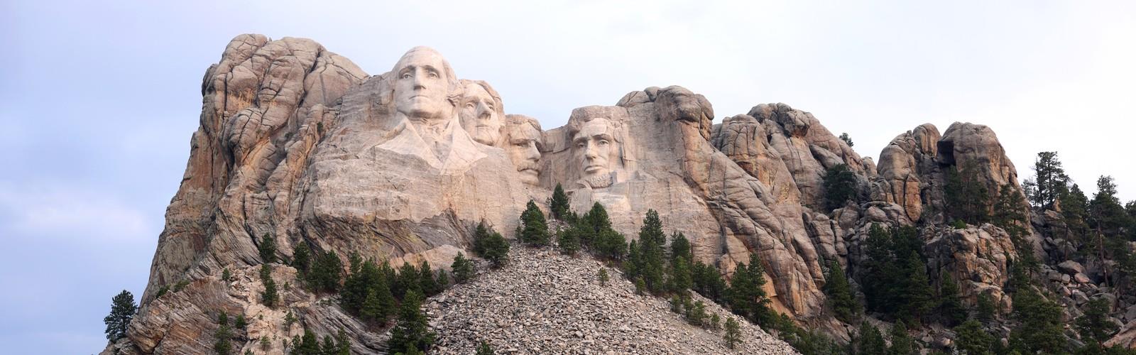
Mount Rushmore is one of the most recognized landmarks in the United States, and visiting it on foot adds a layer to the experience that you simply can't get from a car window. Carved into the granite face of the Black Hills in South Dakota, the memorial features the 60-foot faces of four U.S. presidents — George Washington, Thomas Jefferson, Theodore Roosevelt, and Abraham Lincoln — and the trail system around the site gives you a chance to take it all in at your own pace.
What to Expect on the Ground
The main walking route at Mount Rushmore is the Presidential Trail, a paved loop that winds through the forest below the sculpture and brings you to the closest viewing points available to the public. The trail descends from the main viewing terrace and takes you through a mix of granite boulders, ponderosa pine forest, and open boardwalk sections that frame the carving from different angles. Some sections include stairs, so it's worth knowing that ahead of time if you're visiting with strollers or have mobility considerations.
The path is well-maintained and clearly marked throughout. Even on busy days, the flow of foot traffic tends to move steadily, and there are spots along the way where you can step aside, slow down, and actually look up without getting jostled. The closer you get to the base of the mountain, the more the scale of the sculpture starts to register — photos don't fully prepare you for how massive the carvings actually are.
The Setting
Mount Rushmore sits within the Black Hills, a region of forested granite peaks that feels distinct from the open plains surrounding it. The landscape around the memorial is rugged and textured — exposed rock outcroppings, dense stands of ponderosa pine, and the kind of terrain that makes it clear why this area was considered sacred by the Lakota Sioux long before the carving began in 1927. That history is part of the full picture here, and it's worth sitting with as you walk the trail.
The granite itself is striking up close. You'll notice the texture of the rock, the scale of the blasting and carving work, and the way light hits the faces differently depending on the time of day. Morning light tends to be particularly good for photography, as the sun hits the sculpture directly from the east.
The Memorial Grounds
Beyond the trail, the Mount Rushmore National Memorial has a well-developed visitor infrastructure. The Lincoln Borglum Visitor Center offers exhibits on the history of the carving and the sculptor Gutzon Borglum, who led the project. The Sculptor's Studio, located near the base of the mountain, displays original tools and models used during construction and is one of the more interesting stops on the grounds.
The Avenue of Flags lines the main walkway leading to the viewing terrace and features flags representing all U.S. states, territories, and the District of Columbia. It's a deliberate and visually striking approach to the memorial that sets the tone before you even reach the sculpture.
There's also an amphitheater on site that hosts an evening lighting ceremony during the summer season, where the faces are illuminated after dark. It's a different way to experience the memorial and worth checking the schedule if you're in the area for more than a day.
Practical Information
Mount Rushmore National Memorial is managed by the National Park Service. There is no entrance fee to access the memorial itself, but there is a parking fee for the main parking structure. The parking area is large and can accommodate both passenger vehicles and RVs, though it fills up quickly during peak summer months. Arriving early in the morning is the most reliable way to avoid long waits for parking.
The memorial is open year-round, though some facilities and programs are seasonal. The Presidential Trail and viewing areas are accessible throughout the year, weather permitting. South Dakota winters can bring snow and cold temperatures to the Black Hills, so check conditions before visiting in the off-season.
- Entrance fee: No charge to enter the memorial
- Parking: Fee-based parking structure on site
- Managed by: National Park Service
- Trail surface: Paved with boardwalk sections; includes stairs
- Facilities: Visitor center, gift shop, café, restrooms
- Open: Year-round (hours vary by season)
Who It's Good For
Mount Rushmore works well for a wide range of visitors. The Presidential Trail is accessible enough for most people, including older visitors and kids, though the stairs and uneven sections near the base require some attention. If you're traveling with young children, the paved surfaces and relatively short walking distances make it manageable. History buffs, photography enthusiasts, and anyone with an interest in American landmarks will find plenty to engage with beyond just the view of the sculpture.
If you're looking to extend your time in the area, the Black Hills offer a strong network of additional hiking trails, and nearby sites like Custer State Park and Crazy Horse Memorial are worth building into a longer trip through the region.
A Note on the History
The land on which Mount Rushmore stands is part of the He Sapa, or Black Hills, which holds deep spiritual and cultural significance for the Lakota Sioux Nation. The 1868 Treaty of Fort Laramie recognized the Black Hills as Lakota territory, but the land was later seized by the U.S. government following the discovery of gold. That context is an important part of understanding what you're visiting, and the National Park Service has made efforts in recent years to incorporate Indigenous perspectives into the memorial's interpretation. It's a complicated site with a layered history, and engaging with that honestly makes for a more complete visit.
The Essential Hiking Checklist
Everything you need for your next hike. Bilingual, printable, 1 page.
Get your free hiking checklistRecommended gear for this trail
As an Amazon Associate I earn from qualifying purchases.


Ready to go?
Everything you need to know before you goWhen?
How much?
As an Amazon Associate I earn from qualifying purchases.
Affiliate links — LGPO may earn a commission at no extra cost to you.
- Hiking shoes Essential
- → Salomon Elixir Tour Mid WP · 203.38 $
- Layered clothing Essential
- Rain jacket Essential
- Trekking poles
- → Black Diamond Trail Ergo Cork · 69.99 $
- Headlamp
- → Petzl Actik Core 625 · 103.95 $
FAQ - Frequently asked questions
Everything you need to knowSimilar hikes nearby
Discover other trails you might enjoy
Hiking near Brandon
5 trails to explore ~714 km away
We work hard to provide the most up-to-date and error-free data possible. If something seems incorrect, let us know! Your contribution helps the whole community.
Hikers' opinions
Be the first to review!
No hiker has shared their experience yet. Share your impressions and help other hikers!