

Ready to explore Big Jay, Vermont? Here's everything you need to know before you go!
Discover the trail
Trail description
Description
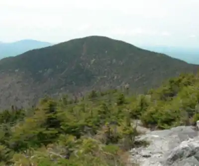
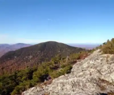
Big Jay is one of those peaks in Vermont that feels genuinely remote — the kind of place where you earn a backcountry mountain experience. Tucked in the northern reaches of the Green Mountains near the Canadian border, Big Jay sits in a landscape that sees far fewer boots than the more popular summits to the south. If you're looking for a hike that feels like an actual wilderness experience rather than a crowded trail, this one delivers.
The Terrain
The approach to Big Jay follows a steady, low-incline grade through dense northern hardwood and boreal forest — expect a mix of yellow birch, sugar maple, and balsam fir as you gain elevation. The forest canopy shifts noticeably as you move higher, transitioning into the kind of tight, mossy spruce-fir zone that defines Vermont's higher summits. The understory is thick, the trail can be rooty and wet in sections, and there are stretches where you'll encounter exposed rock.
The upper mountain features small rock scrambles, particularly in the final 0.4 miles to the summit. The trail doesn't hold your hand getting there. Footing can be tricky, especially on wet rock, so trekking poles and solid footwear are genuinely useful here, not just optional accessories.
What You'll Find at the Top
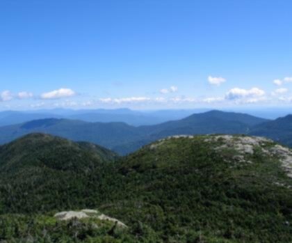
Big Jay rewards the effort with open ledges and views across the surrounding terrain. From the summit, you can see across the landscape to the north toward Quebec and the immediate surroundings. The terrain unfolds in the direction of Vermont's Northeast Kingdom and toward the Champlain Valley region. Visibility and specific viewpoints depend on atmospheric conditions and exact positioning on the summit ledges. The summit itself is rocky and exposed, which means it can be significantly colder and windier than the trailhead, even on a warm day. Layering up before you step out onto the ledges is a habit worth keeping.
What Makes Big Jay Stand Out
What sets Big Jay apart from a lot of Vermont hikes is the combination of genuine remoteness and a real summit experience. You're not going to run into crowds here. The trailhead isn't on a major highway, the hike isn't a quick loop, and the summit doesn't have a fire tower drawing day-trippers. What you get instead is a mountain that feels like it belongs to whoever shows up willing to work for it.
The northern Vermont setting also means the wildlife and plant communities are a bit different from what you'd encounter further south in the state. This is moose country. Black bear are present. The birdlife in the boreal zone — including species like Bicknell's thrush at higher elevations — reflects the northern character of the landscape. Keep your eyes and ears open on the way up.
Practical Considerations
The access road and trailhead conditions matter here more than on many Vermont hikes. The road to the trailhead can be rough, and in mud season or after significant rain, a vehicle with decent clearance is a real advantage. Check conditions before you go, especially in spring.
There is no fee to hike Big Jay, and the trail is on land managed for public access, but this isn't a heavily maintained, sign-posted trail system. Come prepared to navigate, carry a map, and don't rely solely on cell service for route-finding — coverage in this part of Vermont is inconsistent at best.
- Footwear: Waterproof hiking boots with ankle support are strongly recommended given the rooty, rocky, and potentially wet trail conditions.
- Navigation: Bring a paper map or downloaded offline map. Cell service is unreliable in this area.
- Weather: Summit conditions can change quickly. Wind and cold at the top are common even when it's mild at the trailhead.
- Season: Mud season in Vermont (typically mid-April through late May) can make the trail and access road significantly more difficult. Late spring through fall tends to offer the best conditions.
- Dogs: Dogs are generally welcome on this trail but should be kept under control given the wildlife in the area.
Getting There
Big Jay is located in the northern Green Mountains on the border of Franklin and Orleans counties, near the town of Jay. The most common route climbs Jay Peak via the Long Trail from VT route 242, then takes a herd path from there. From Burlington, VT, it's approximately 70 miles and 1.5 hours of driving. The trailhead is accessed via a dirt road, and the final stretch of driving requires some attention — this isn't a paved parking lot situation. Give yourself extra time on the approach if you're unfamiliar with the area, and make sure your vehicle is fueled up before heading into this corner of Vermont, where services are sparse.
Parking at the trailhead is limited, so arriving early on busy weekends in fall foliage season is a good idea, though Big Jay will almost always be quieter than the more trafficked peaks in the state.
Who This Hike Is For
Big Jay is a moderate-rated hike best suited for hikers with some hiking experience who are comfortable on unmaintained terrain. The small rock scrambles near the summit mean this isn't the right choice for young children or anyone who isn't steady on their feet on exposed rock. That said, it's not a technical climb — it's a moderate hike with a scramble finish, and experienced hikers will find it well within reach.
If you've done the standard Vermont summit hikes and you're looking for something that feels less like a managed experience and more like a real mountain day, Big Jay is exactly that kind of hike.
Recommended gear for this trail


Ready to go?
Everything you need to know before you goStarting Point
To access the hiking trails, you can start at the following trailheads:
Jay Peak Resort Parking Lot: Located at 830 Jay Peak Road, Jay, VT 05859. This is a common starting point for accessing the trails leading to the summit.
Long Trail North Trailhead: Situated on Route 242, approximately 3 miles west of the resort. There is a small parking area available for hikers.
These locations provide convenient access to the hiking routes in the area.
When?
How much?
- Hiking shoes Essential
- → Salomon Elixir Tour Mid WP · 203.38 $
- Layered clothing Essential
- Rain jacket Essential
- Trekking poles
- → Black Diamond Trail Ergo Cork · 69.99 $
- Headlamp
- → Petzl Actik Core 625 · 103.95 $
FAQ - Frequently asked questions
Everything you need to knowThe Essential Hiking Checklist
Everything you need for your next hike. Bilingual, printable, 1 page.
Download the free checklistSimilar hikes nearby
Discover other trails you might enjoy

Arthur Park
Champlain Valley
Eagle Mountain Natural Area
Champlain Valley
Sunset Ridge Trail
Champlain Valley
Mount Mansfield, Vermont
Champlain Valley
Causeway Park
Champlain Valley
Burton Island State Park
Champlain Valley
Hiking near Stowe
0 trails to explore ~51 km away
We work hard to provide the most up-to-date and error-free data possible. If something seems incorrect, let us know! Your contribution helps the whole community.
Hikers' opinions