

Ready to explore Camel's Hump, Vermont? Here's everything you need to know before you go!
Discover the trail
Trail description
Description
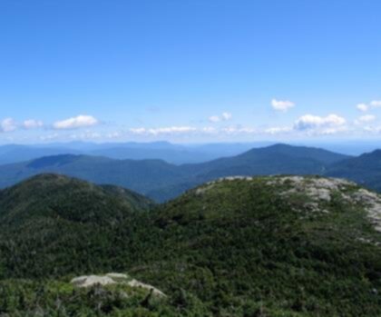
Camel's Hump is one of Vermont's most iconic peaks — a bare, rocky summit that stands out on the skyline and draws hikers from across the region. Unlike many mountains that blend into the ridgeline, Camel's Hump has a distinctive double-humped silhouette that makes it instantly recognizable. It's a serious mountain that rewards serious effort, and it's been a landmark in Vermont's outdoor culture for generations.
The Summit Experience
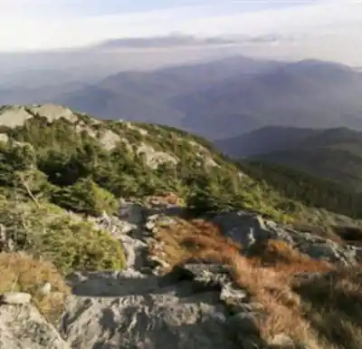
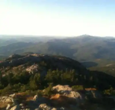
The top of Camel's Hump is above treeline, which is relatively rare in Vermont. That means you get genuine alpine tundra — a fragile, wind-scoured environment with low-growing vegetation that takes decades to recover from a single careless footstep. The views from the summit are expansive: the Green Mountains stretch out in both directions, Lake Champlain sits to the west with the Adirondacks rising beyond it, and on a clear day you can see well into New York and Quebec.
Because the summit is exposed and the terrain is genuine alpine, conditions up top can be dramatically different from what you left at the trailhead. Wind, cold, and fast-moving weather are all real factors here, even in summer. This isn't a place to be caught underprepared.
The Terrain
The approach to Camel's Hump involves significant elevation gain through dense northern hardwood and boreal forest before breaking out into the open alpine zone near the top. The trails are rocky and rooted in sections, with some steeper pitches that require hands-on scrambling as you get closer to the summit. The footing demands attention — this isn't a casual stroll, and trail runners or sturdy hiking boots are the right call.
Multiple trail routes lead to the summit, giving hikers options depending on their starting point and how much distance they want to cover. Some routes are more direct and steep; others take a longer, more gradual approach through the forest. The variety of access points means you can tailor the experience to your group's fitness level and goals.
The Alpine Zone — Tread Carefully
The alpine tundra at the summit of Camel's Hump is one of only two places in Vermont where this ecosystem exists naturally. That makes it genuinely special — and genuinely vulnerable. The plants growing up there are adapted to extreme conditions, but they can't handle foot traffic. Staying on the marked trail and on bare rock when you're above treeline isn't just a suggestion — it's the difference between a healthy ecosystem and a degraded one.
Camel's Hump State Park manages the area with conservation as a clear priority. Expect to see trail markers and signage reminding hikers to stay on designated paths, especially near the summit. Summit caretakers are often present during the busy season to help visitors navigate the area responsibly.
Wildlife and Natural Features
The forest on the way up supports a range of wildlife typical of Vermont's northern forests — white-tailed deer, black bear, various raptors, and a rich bird community that shifts as you gain elevation. The boreal zone near the summit hosts species you won't find lower down, including Bicknell's thrush, a rare bird that nests in high-elevation spruce-fir habitat and is closely associated with mountains like Camel's Hump.
The transition from hardwood forest to boreal spruce-fir to open alpine tundra as you climb is one of the more compelling ecological experiences available on a single Vermont hike. You're essentially moving through multiple climate zones in the span of a few hours.
Practical Information
Camel's Hump is a popular destination, and the parking areas can fill up early on weekends and during peak foliage season. Getting an early start is strongly recommended — both to secure parking and to give yourself plenty of time on the mountain before afternoon weather rolls in.
- Trailheads: There are several access points to Camel's Hump, including trailheads in Huntington and Duxbury. Each offers a different route to the summit with varying distances and character.
- Dogs: Dogs are permitted on the trails but must be kept under control. On the alpine summit, keeping dogs on leash and on rock is important to protect the fragile vegetation.
- Leave No Trace: Pack out everything you bring in. There are no facilities at the summit.
- Weather: Check the forecast before you go and be prepared for conditions to change quickly above treeline. Wind and cold are possible any time of year at the summit.
- Season: The mountain is accessible year-round, but winter ascents require appropriate gear and experience with cold-weather travel. Spring mud season can make trails particularly rough and erosion-prone — some hikers choose to wait until conditions firm up.
What Makes Camel's Hump Stand Out
Vermont has plenty of good hiking, but Camel's Hump occupies a different category. The combination of a genuine alpine summit, rare tundra ecosystem, long-range views, and a mountain that actually feels like a mountain — with real exposure and real effort required — puts it in a short list of must-do hikes in the northeastern United States. It's not a beginner outing, but it's also not out of reach for anyone who's reasonably fit and comes prepared.
The mountain has been protected as part of Camel's Hump State Park for decades, and that long history of conservation shows in the quality of the experience. The trails are well-maintained, the signage is clear, and the summit, while busy on peak days, still feels like a place worth protecting.
If you're looking for a hike in Vermont that delivers a full mountain experience — real terrain, real views, and a genuine sense of accomplishment — Camel's Hump consistently delivers.
Recommended gear for this trail


Ready to go?
Everything you need to know before you goStarting Point
To access the hiking trails, you can start at several trailheads:
Monroe Trailhead: Located at Camel's Hump Road, Duxbury, VT 05676. This is a popular starting point with parking available.
Burrows Trailhead: Found at Camel's Hump Road, Huntington, VT 05462. There is a parking lot here as well.
Forest City Trailhead: Situated on Camel's Hump Road in Huntington, VT 05462, near the Burrows Trailhead.
Each of these locations provides access to different routes up the mountain.
When?
How much?
- Hiking shoes Essential
- → Salomon Elixir Tour Mid WP · 203.38 $
- Layered clothing Essential
- Rain jacket Essential
- Trekking poles
- → Black Diamond Trail Ergo Cork · 69.99 $
- Headlamp
- → Petzl Actik Core 625 · 103.95 $
FAQ - Frequently asked questions
Everything you need to knowThe Essential Hiking Checklist
Everything you need for your next hike. Bilingual, printable, 1 page.
Download the free checklistSimilar hikes nearby
Discover other trails you might enjoy

Arthur Park
Champlain Valley
Eagle Mountain Natural Area
Champlain Valley
Sunset Ridge Trail
Champlain Valley
Mount Mansfield, Vermont
Champlain Valley
Causeway Park
Champlain Valley
Burton Island State Park
Champlain Valley
Hiking near Stowe
0 trails to explore ~23 km away
We work hard to provide the most up-to-date and error-free data possible. If something seems incorrect, let us know! Your contribution helps the whole community.
Hikers' opinions