

Ready to explore Catamount Trl? Here's everything you need to know before you go!
Discover the trail
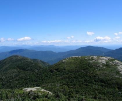
Oh no! We don't have any photos 😢
This trail hasn't been captured yet. Be the first to share your adventure!Trail description
Description
The Catamount Trail is one of Vermont's most iconic long-distance routes, running the length of the state from the Massachusetts border all the way to the Canadian border. Designed primarily as a cross-country skiing trail, it winds through forests, farmland, and mountain terrain across the Champlain Valley and beyond, connecting communities and wild landscapes in a way that few trails in the Northeast can match.
In the Champlain Valley section, the trail takes on a character that's distinctly different from the high-elevation stretches found elsewhere in Vermont. Here, the terrain flattens out considerably, and the route moves through a mix of agricultural land, woodlots, and quiet rural corridors. It's a section that rewards those who appreciate wide-open views, pastoral scenery, and a more accessible style of travel through the Vermont countryside.
What Makes the Catamount Trail Unique
Unlike most hiking trails that follow a single corridor from trailhead to summit, the Catamount Trail is a point-to-point route that was built to be traveled in segments. The Champlain Valley portion reflects the geography of the region — relatively low elevation, open fields, and a landscape shaped as much by farming as by wilderness. This isn't a trail where you're pushing through dense backcountry; it's a route that puts you in direct contact with the working landscape of Vermont.
The trail is maintained by the Catamount Trail Association, a nonprofit organization that has been stewarding this route since the 1980s. Their work keeps the trail passable and well-marked across its many segments, including the Champlain Valley stretch.
Terrain and Trail Character
Through the Champlain Valley, the Catamount Trail moves across gently rolling terrain. Expect a mix of open meadows, hedgerows, and forested sections where the canopy closes in and the trail narrows. The ground underfoot varies — packed dirt, grassy corridors, and occasional muddy patches depending on the season and recent weather.
Because this section sits at lower elevation than the Green Mountains to the east, the views here tend to be horizontal rather than vertical. On clear days, you can pick out the Adirondacks to the west across Lake Champlain, and the ridge of the Green Mountains to the east. It's a perspective on Vermont's geography that you simply don't get from a summit.
The trail crosses a combination of private land and public parcels, which is part of what makes the Catamount Trail distinctive — and also why staying on the marked route matters. Landowner cooperation is essential to keeping this trail open, so respecting boundaries and following the blue blazes is important.
Getting Around the Champlain Valley Section
Access points in the Champlain Valley section vary, and the trail is best approached with a current map from the Catamount Trail Association. Because the trail spans the full length of Vermont, most people tackle it in day-long or multi-day segments rather than attempting a thru-hike all at once. The Champlain Valley segment is well-suited to a relaxed day out, with the relatively flat terrain making it approachable for a wide range of fitness levels.
Parking availability depends on the specific access point you choose. The Catamount Trail Association's website and guidebook are the most reliable sources for current trailhead information, including any seasonal closures or reroutes.
Seasons and Conditions
The Catamount Trail was originally designed as a ski touring route, and winter remains one of the best times to experience it. A good snow base transforms the Champlain Valley section into a quiet, beautiful corridor through snow-covered fields and woods. The flat terrain here makes it one of the more beginner-friendly stretches for classic cross-country skiing.
In the warmer months, the trail is hikeable and bikeable in many sections, though it's worth checking current conditions before heading out. Spring can bring significant mud, particularly in lower-lying areas of the Champlain Valley. Summer and fall are generally the most reliable seasons for dry footing, and fall color in this part of Vermont can be exceptional — the mix of open farmland and hardwood forest creates a patchwork of reds, oranges, and yellows that's worth timing a visit around.
Wildlife and Natural Features
The Champlain Valley is one of Vermont's most ecologically rich regions, and the Catamount Trail passes through habitat that supports a wide range of wildlife. The agricultural landscape, while human-shaped, provides important edge habitat for deer, foxes, and a variety of bird species. Wetland areas along the route attract waterfowl and shorebirds, particularly during migration seasons.
The proximity to Lake Champlain adds another layer to the natural character of this section. The lake moderates the local climate and supports ecosystems that you won't find in the higher, colder parts of Vermont. Keep an eye out for raptors — red-tailed hawks and northern harriers are commonly seen hunting over open fields in this part of the valley.
Practical Tips
- Get the official map: The Catamount Trail Association publishes a detailed guidebook and maps that are essential for navigating the full trail, including the Champlain Valley section. Don't rely solely on general mapping apps for this one.
- Respect private land: A significant portion of the trail crosses private property. Stay on the marked route and leave gates as you find them.
- Blue blazes are your guide: The trail is marked with blue blazes throughout. If you lose the blazes, backtrack rather than guessing.
- Check conditions seasonally: Spring mud and winter snow depth can significantly affect trail accessibility. The Catamount Trail Association posts updates on current conditions.
- Dogs: Policies vary depending on which land parcels the trail crosses in this section. Check with the Catamount Trail Association for current guidance.
About the Catamount Trail Association
The Catamount Trail Association is the organization responsible for building, maintaining, and promoting the Catamount Trail. They work directly with landowners, volunteers, and partner organizations to keep the trail accessible and in good condition year-round. Supporting their work — whether through membership, volunteering, or simply following trail etiquette — helps ensure this remarkable route stays open for future users.
Recommended gear for this trail


Ready to go?
Everything you need to know before you goStarting Point
The Catamount Trail is located in the Green Mountain National Forest in Vermont. The easiest way to get there is to take Route 4 from Rutland to Manchester. In Manchester, take Route 7A west to Arlington. The trailhead is located on the left side of the road about 1.5 miles after the junction with Route 7A.
When?
How much?
- Hiking shoes Essential
- → Salomon Elixir Tour Mid WP · 203.38 $
- Layered clothing Essential
- Rain jacket Essential
- Trekking poles
- → Black Diamond Trail Ergo Cork · 69.99 $
- Headlamp
- → Petzl Actik Core 625 · 103.95 $
FAQ - Frequently asked questions
Everything you need to knowThe Essential Hiking Checklist
Everything you need for your next hike. Bilingual, printable, 1 page.
Download the free checklistSimilar hikes nearby
Discover other trails you might enjoy

Arthur Park
Champlain Valley
Eagle Mountain Natural Area
Champlain Valley
Mount Mansfield, Vermont
Champlain Valley
Sunset Ridge Trail
Champlain Valley
Causeway Park
Champlain Valley
Burton Island State Park
Champlain Valley
Hiking near Stowe
0 trails to explore ~27 km away
We work hard to provide the most up-to-date and error-free data possible. If something seems incorrect, let us know! Your contribution helps the whole community.
Hikers' opinions
Be the first to review!
No hiker has shared their experience yet. Share your impressions and help other hikers!