

Ready to explore Mount Abraham, Vermont? Here's everything you need to know before you go!
Discover the trail

Trail description
Description
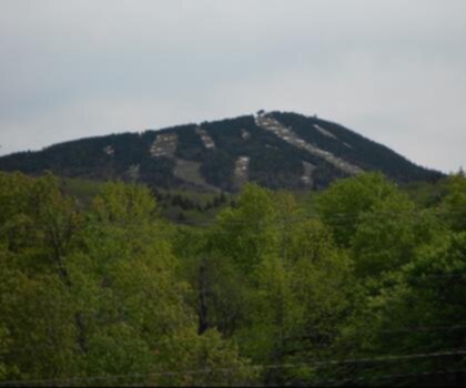
Mount Abraham is one of Vermont's five peaks that rises above 4,000 feet, and it earns its place on that short list. The summit sits above treeline, offering a wide-open alpine zone that's genuinely rare in the Green Mountains. If you're looking for a hike that rewards you with real above-treeline exposure without crossing into New Hampshire, this is one of your best options in the state.
The Trail Experience
The most common approach to Mount Abraham follows the Long Trail, Vermont's iconic end-to-end footpath that runs the length of the state along the spine of the Green Mountains. The climb is steady and honest — nothing technical, but it doesn't let up much either. You'll move through dense northern hardwood forest in the lower sections, then transition into boreal spruce-fir as you gain elevation. The forest gets shorter and more gnarled as you push higher, and then the trees simply stop.
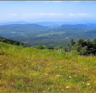
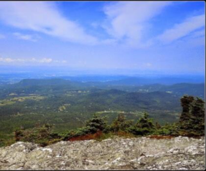
That transition to open alpine terrain is the moment most hikers remember. The final approach to the summit is rocky and exposed, with views opening up in multiple directions. On a clear day, the panorama stretches across the Champlain Valley to the west, with the Adirondacks of New York visible beyond the lake. To the east, you're looking out over the Mad River Valley and the rolling terrain of central Vermont.
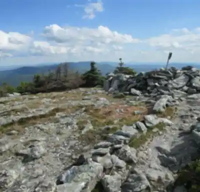
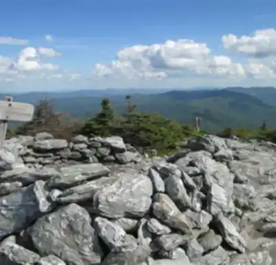
The Summit Zone
The alpine zone on Mount Abraham is small but ecologically significant. This type of habitat — true arctic-alpine tundra — exists on only a handful of Vermont summits. The plants growing up here are fragile and slow-growing. Staying on the marked trail and on rock surfaces when you're above treeline isn't just trail etiquette; it's genuinely important for protecting vegetation that can take decades to recover from a single footstep off-route.
You'll notice low-growing plants hugging the rock — mountain sandwort, Bigelow's sedge, and other species adapted to the harsh conditions at this elevation. The summit cairn marks the high point, and it's a solid spot to stop, eat something, and take in the full sweep of the landscape before heading back down.
Getting There
The standard trailhead for Mount Abraham is the Lincoln Gap trailhead, accessed via Lincoln Gap Road, which connects the towns of Lincoln and Warren. Lincoln Gap Road is a narrow mountain road that closes in winter — typically from late fall through late spring — so timing your visit matters. The parking area at the gap is small, and it fills up quickly on weekends during peak season. Getting there early in the morning is the practical move if you're visiting on a Saturday or Sunday in summer or fall.
From Lincoln Gap, you pick up the Long Trail heading north toward the summit. The trail is well-marked with the Long Trail's characteristic white blazes.
What to Know Before You Go
- Alpine zone care: Stay on the marked trail and on rock surfaces above treeline. The alpine vegetation is protected and extremely vulnerable to foot traffic.
- Road access: Lincoln Gap Road closes seasonally. Check current conditions before planning a shoulder-season trip.
- Parking: The trailhead lot is small. Arrive early on weekends to secure a spot.
- Weather: Summit conditions can change fast. The exposed ridgeline and open summit mean wind and temperature drops that won't be obvious at the trailhead. Bring an extra layer even on warm days.
- Dogs: Dogs are permitted on the Long Trail but must be under control. Keep them on the marked trail in the alpine zone.
Seasons and Timing
Summer and fall are the primary seasons for this hike. Fall foliage from the summit is exceptional — the Mad River Valley and Champlain Valley spread out below you in full color, and the elevation gives you a perspective that's hard to match in the region. Summer offers the longest days and the best chance of clear summit views, though afternoon thunderstorms are a real consideration and the exposed summit is not a place to be when lightning is in the area.
Spring hiking on Mount Abraham is complicated by mud season, which can make the lower trail sections rough and causes real erosion damage when hikers go around wet spots and widen the trail. If you're visiting in spring, check trail conditions and consider waiting until the trail has dried out. Winter access requires snowshoes or microspikes depending on conditions, and the closed road means a significantly longer approach.
The Broader Context
Mount Abraham sits within the Green Mountain National Forest, managed by the U.S. Forest Service. The Long Trail itself is maintained by the Green Mountain Club, which has been stewarding this footpath since 1910. The club maintains shelters along the trail corridor, and the Battell Shelter sits below the summit and serves as an overnight option for those doing a multi-day Long Trail section.
Within the Green Mountains, Mount Abraham stands out specifically because of that above-treeline summit. Many of the range's peaks top out in forest, which makes for pleasant hiking but limits the big views. Here, you get the full alpine experience — the open sky, the wind, the sense of being genuinely above the surrounding landscape — which is what draws people back to this summit repeatedly.
Who This Hike Is For
Mount Abraham works well for hikers who are comfortable with sustained elevation gain on rocky trail and want a genuine summit experience with above-treeline exposure. It's not a beginner hike, but it's also not a technical climb — fit hikers with some trail experience will find it very manageable. The payoff in terms of views and alpine terrain is high relative to the effort, which is why it consistently draws hikers from across Vermont and beyond.
If you've been working your way through Vermont's 4,000-footers, Mount Abraham is a satisfying entry on that list — and the summit views across the Champlain Valley make it one of the more memorable ones.
Recommended gear for this trail


Ready to go?
Everything you need to know before you goStarting Point
To access the hiking trails, you can start at the Lincoln Gap Trailhead. The address is Lincoln Gap Road, Warren, VT 05674. This trailhead provides parking and is a common starting point for hikers. Note that Lincoln Gap Road may be closed during winter months, so it's advisable to check road conditions before planning your visit.
When?
How much?
- Hiking shoes Essential
- → Salomon Elixir Tour Mid WP · 203.38 $
- Layered clothing Essential
- Rain jacket Essential
- Trekking poles
- → Black Diamond Trail Ergo Cork · 69.99 $
- Headlamp
- → Petzl Actik Core 625 · 103.95 $
FAQ - Frequently asked questions
Everything you need to knowThe Essential Hiking Checklist
Everything you need for your next hike. Bilingual, printable, 1 page.
Download the free checklistSimilar hikes nearby
Discover other trails you might enjoy
Snowdon Peak, Vermont
Green Mountains

Slate Valley Trails
Green Mountains
Flatlander Farm
Green Mountains
Bristol Tripadvisor #1, Vermont Bed and Breakfast at Russell Young Farm
Green Mountains
Deer Leap Trail
Green Mountains
Killington Peak
Green Mountains
Hiking near Montpelier
0 trails to explore ~33 km away
We work hard to provide the most up-to-date and error-free data possible. If something seems incorrect, let us know! Your contribution helps the whole community.
Hikers' opinions