

Ready to explore Slate Valley Trails? Here's everything you need to know before you go!
Discover the trail
Oh no! We don't have any photos 😢
This trail hasn't been captured yet. Be the first to share your adventure!Trail description
Description
The Slate Valley Trails are a network of multi-use trails tucked into the Green Mountains of Vermont, offering hikers, mountain bikers, and outdoor enthusiasts a genuinely rewarding experience in a landscape shaped by centuries of slate quarrying history. This is the kind of place where the natural world and industrial heritage overlap in unexpected ways — and that combination makes it stand out from more conventional trail systems in the region.
The Landscape and Terrain
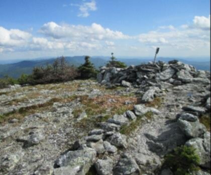
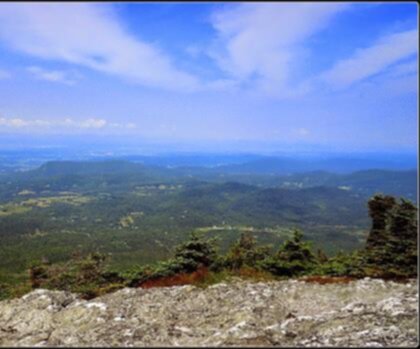
The trails wind through a rugged, forested terrain that reflects the geological character of the Slate Valley. The area gets its name from the extensive slate deposits that were actively quarried here for generations, and evidence of that history is woven into the landscape itself. As you move through the trail network, you'll encounter old quarry pits, slate outcroppings, and remnants of the extraction industry that once defined this corner of Vermont. It's not a manicured park experience — the terrain is raw and honest, which is exactly what draws people back.
The forest cover is dense and varied, with a mix of hardwoods and conifers that shift as you gain or lose elevation across the network. The ground underfoot changes frequently, moving between rooted singletrack, open slate shelves, and softer forest floor sections. That variety keeps the trails interesting and demands a bit of attention, especially after rain when slate surfaces can get slick.
Trail Network and Use
The Slate Valley Trails are designed as a shared-use system, meaning hikers and mountain bikers share the same paths. If you're coming on foot, that's worth knowing ahead of time — especially on weekends when bike traffic can be heavier. The trails are generally well-marked, and the network offers options for different ability levels, from more relaxed loops to routes that push into steeper, more technical terrain.
Because this is a trail network rather than a single out-and-back route, you have real flexibility in how you put together your day. You can keep things short and exploratory, or link sections together for a longer outing. First-time visitors are encouraged to grab a trail map before heading out, since the network has multiple intersections and it's easy to lose your bearings if you're not paying attention.
The Quarrying Heritage
What genuinely sets the Slate Valley Trails apart from other Green Mountain trail systems is the visible quarrying history embedded in the landscape. Vermont's Slate Valley was one of the most productive slate-producing regions in North America, and the towns surrounding this trail network grew up around that industry. Walking these trails, you're moving through a working landscape that has been transformed over time — first by extraction, and now by conservation and recreation.
The old quarry pits are a striking feature. Some have filled with water over the decades, creating still, dark pools that reflect the surrounding forest. Others remain open, with sheer slate walls that give you a clear sense of the scale of the operation that once ran here. These aren't fenced-off hazards — they're part of the experience, and they reward the kind of slow, observant hiking that lets you actually take in what you're walking through.
What to Expect on the Trail
The Slate Valley Trails reward hikers who come prepared and curious. The terrain is not technically demanding in the way that alpine routes in Vermont can be, but it's not a casual stroll either. Footing requires attention, particularly on slate surfaces and rooted sections. Good footwear matters here — trail runners or hiking boots with solid grip will serve you much better than casual sneakers.
The forest provides good shade through most of the trail network, which makes summer hiking comfortable even on warmer days. In fall, the hardwood canopy puts on a strong show, and the contrast between the colorful foliage and the grey slate outcroppings is genuinely striking. Spring can bring muddy conditions, and some sections may be soft or waterlogged after snowmelt or heavy rain.
Practical Information
- Trail type: Multi-use network shared by hikers and mountain bikers
- Terrain: Mixed forest singletrack, slate outcroppings, rooted paths
- Highlights: Historic quarry pits, slate geology, dense forest cover
- Footing: Can be slippery on wet slate — appropriate footwear recommended
- Navigation: Multiple intersections throughout the network — carry a trail map
- Shared use: Expect mountain bike traffic, particularly on weekends
Getting There
The Slate Valley Trails are located in the Green Mountains region of Vermont. Access points and parking details are best confirmed through local trail resources or the managing organization before your visit, as trailhead information can change seasonally. Vermont's rural road network in this area can be narrow and unpaved in sections, so knowing your access point in advance saves time and frustration.
Why It's Worth the Trip
The Slate Valley Trails offer something that's harder to find in more heavily visited parts of Vermont — a trail experience that feels genuinely connected to the place it's in. The quarrying history isn't just a backdrop; it's actively present in the landscape, giving the hike a layer of context that you don't get on a generic forest trail. Combined with solid terrain variety and the flexibility of a multi-use network, this is a destination that holds up well for repeat visits and rewards hikers who take their time and pay attention to what's around them.
Recommended gear for this trail


Ready to go?
Everything you need to know before you goStarting Point
The slate valley trails are located in the town of Granville, Vermont. To get to the start of the trails, take exit 6 off of I-87 and head east on VT-22. The trailhead is located at the end of VT-22.
When?
How much?
- Hiking shoes Essential
- → Salomon Elixir Tour Mid WP · 203.38 $
- Layered clothing Essential
- Rain jacket Essential
- Trekking poles
- → Black Diamond Trail Ergo Cork · 69.99 $
- Headlamp
- → Petzl Actik Core 625 · 103.95 $
FAQ - Frequently asked questions
Everything you need to knowThe Essential Hiking Checklist
Everything you need for your next hike. Bilingual, printable, 1 page.
Download the free checklistSimilar hikes nearby
Discover other trails you might enjoy
Mount Abraham, Vermont
Green Mountains
Snowdon Peak, Vermont
Green Mountains

Flatlander Farm
Green Mountains
Bristol Tripadvisor #1, Vermont Bed and Breakfast at Russell Young Farm
Green Mountains
Deer Leap Trail
Green Mountains
Killington Peak
Green Mountains
Hiking near Saratoga Springs
0 trails to explore ~66 km away
We work hard to provide the most up-to-date and error-free data possible. If something seems incorrect, let us know! Your contribution helps the whole community.
Hikers' opinions