

Ready to explore Snowdon Peak, Vermont? Here's everything you need to know before you go!
Discover the trail
Oh no! We don't have any photos 😢
This trail hasn't been captured yet. Be the first to share your adventure!Trail description
Description
Snowdon Peak is one of the quieter summits in Vermont's Green Mountains, but don't let that fool you — this is a genuinely demanding hike that earns its Hard rating. With 9.7 km of trail, 610 m of elevation gain, and a realistic 4-hour round trip, it's the kind of day out that rewards hikers who come prepared and leave the casual stroll mindset at the trailhead.
The Terrain
The Green Mountains are known for their dense northern hardwood and boreal forest cover, and Snowdon Peak fits right into that character. The lower sections of the trail move through a mix of maple, beech, and yellow birch, the kind of forest that turns spectacular in fall and stays cool and shaded through the heat of summer. As you gain elevation, the canopy shifts — spruce and fir take over, the air gets noticeably cooler, and the trail surface becomes rockier and more rooted underfoot.
That 610 m of vertical gain doesn't come all at once, but there are sustained pitches where the trail steepens considerably. Wet conditions make the exposed roots and rock slabs slippery, so traction matters. Waterproof boots with solid ankle support are the right call here, not trail runners.
What to Expect on the Trail
The hike follows a pattern common to Green Mountain summits: a gradual warm-up through the lower forest, a middle section where the climbing gets serious, and a final push through the subalpine zone before the summit. The trail is well-defined but not heavily trafficked, which means you're less likely to be sharing the experience with a crowd — a genuine plus for hikers who come to the mountains for some quiet.
The 4-hour estimate is reasonable for a fit hiker moving at a steady pace with short breaks. If you're bringing kids, newer hikers, or planning to stop for a proper lunch, build in extra time. The terrain in the upper section demands attention and energy, and rushing the descent on tired legs is how ankles get rolled.
Views and Highlights
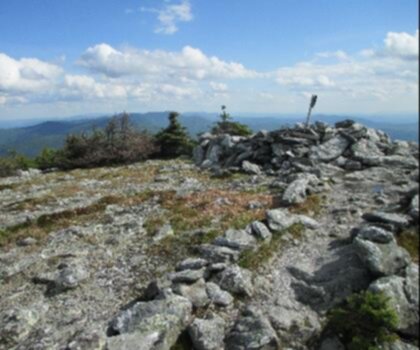
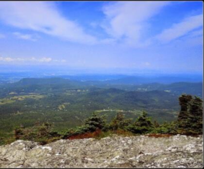
The Green Mountains don't always offer wide-open summit panoramas — the forest cover is thick and the ridgelines are often wooded right to the top. What Snowdon Peak delivers is the experience of the landscape itself: the transition through distinct forest zones, the physical satisfaction of a real climb, and the kind of stillness you only find when you've put in the work to get somewhere most people don't bother going.
Practical Information
- Distance: 9.7 km
- Elevation gain: 610 m
- Difficulty: Hard
- Estimated time: 4 hours
- Region: Green Mountains, Vermont
Getting Ready
Vermont mountain weather changes fast, especially at elevation. Even on a clear morning in the valley, conditions near the summit can be significantly cooler and windier. Bring a layer, carry more water than you think you need, and check the forecast before you head out. The Green Mountains see a lot of precipitation, and a trail that's pleasant in dry conditions can become a slog in the mud — particularly during mud season in spring, when many Vermont trails are better left alone to recover.
Snowdon Peak is the kind of hike that sits in that satisfying middle ground: long and challenging enough to feel like a real accomplishment, but not so committing that it requires a multi-day expedition. If you're looking to push yourself on a Vermont summit without the crowds of the more famous peaks in the range, this one is worth the drive.
Recommended gear for this trail


Ready to go?
Everything you need to know before you goStarting Point
To access the hiking trails, you can start at the primary trailhead located at the end of Mountain Road in Underhill State Park. The address is 352 Mountain Road, Underhill Center, VT 05490. Another option is to begin from the Stevensville Trailhead, which can be found at the end of Stevensville Road in Underhill, Vermont. Both locations offer parking facilities for hikers.
When?
How much?
- Hiking shoes Essential
- → Salomon Elixir Tour Mid WP · 203.38 $
- Layered clothing Essential
- Rain jacket Essential
- Trekking poles
- → Black Diamond Trail Ergo Cork · 69.99 $
- Headlamp
- → Petzl Actik Core 625 · 103.95 $
FAQ - Frequently asked questions
Everything you need to knowThe Essential Hiking Checklist
Everything you need for your next hike. Bilingual, printable, 1 page.
Download the free checklistSimilar hikes nearby
Discover other trails you might enjoy
Mount Abraham, Vermont
Green Mountains

Slate Valley Trails
Green Mountains
Flatlander Farm
Green Mountains
Bristol Tripadvisor #1, Vermont Bed and Breakfast at Russell Young Farm
Green Mountains
Deer Leap Trail
Green Mountains
Killington Peak
Green Mountains
Hiking near Montpelier
0 trails to explore ~74 km away
We work hard to provide the most up-to-date and error-free data possible. If something seems incorrect, let us know! Your contribution helps the whole community.
Hikers' opinions