

Ready to explore Burnt Mountain, Vermont? Here's everything you need to know before you go!
Discover the trail
Trail description
Description
Burnt Mountain in Vermont's Northeast Kingdom is one of those off-the-beaten-path summits that rewards hikers who seek out quieter corners of the Green Mountain State. Far from the crowds that flock to more famous Vermont peaks, this mountain offers a genuine backcountry feel with a satisfying payoff at the top. If you're looking for a place where the trail is more likely to be shared with a moose than another hiker, Burnt Mountain fits the bill.
The Northeast Kingdom Setting
The Northeast Kingdom — locals just call it the NEK — is Vermont's wild northeastern corner, a region defined by dense boreal forests, glacial lakes, and a landscape that feels genuinely remote even by Vermont standards. Burnt Mountain sits right in the heart of this character. The surrounding terrain is classic NEK: mixed hardwood and softwood forest, boggy lowlands, and ridgelines that open up to views stretching across a landscape with very few signs of development. This is the kind of place where the quiet is actually quiet.
The region sees far less foot traffic than the southern Green Mountains, which means trails here tend to stay in a more natural, rugged state. Come prepared for a trail experience that prioritizes the journey over polished infrastructure.
What the Hike Is Like
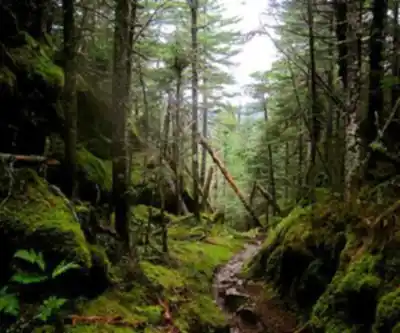
Burnt Mountain delivers a classic Vermont summit hike experience. The trail climbs through forest that shifts as you gain elevation — starting in the mixed hardwoods typical of lower NEK terrain before transitioning into the spruce-fir canopy that dominates higher ground in this part of the state. The forest floor is lush, and the trail itself has the kind of rooted, rocky character that Vermont hikers know well. Footing demands attention, especially on wet days when exposed roots and stones get slippery.
The name "Burnt Mountain" is a nod to the history of the landscape — a common naming convention across the Northeast for summits that were shaped by fire, either naturally or through historical land clearing. That history has left its mark on the vegetation patterns you'll notice as you climb, with areas of younger growth mixed into the older forest.
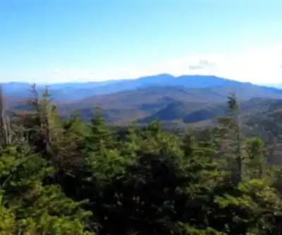
As you approach the upper sections of the mountain, the trees begin to thin and the views start to open. The summit area offers the kind of panoramic perspective that makes the climb worthwhile — rolling forested hills extending in every direction, with the characteristic lack of development that defines the Northeast Kingdom. On a clear day, the sense of scale is genuinely impressive.
Wildlife and Nature
The Northeast Kingdom is serious wildlife country, and Burnt Mountain's surrounding forest is no exception. The dense boreal and mixed forest habitat supports a healthy population of white-tailed deer, black bear, and moose — the latter being a genuine possibility on any hike in this region, particularly near wetland areas at lower elevations. Birdlife is rich, with the boreal forest supporting species like the Blackpoll Warbler, Boreal Chickadee, and various woodpeckers that thrive in the spruce-fir zone.
The NEK's relatively low human pressure means wildlife here behaves more naturally and sightings are more common than in heavily trafficked areas. Keep noise levels reasonable and stay alert, especially in the early morning and evening hours when animal activity peaks.
Seasons and Conditions
Vermont's Northeast Kingdom has a climate that's noticeably more severe than the southern part of the state. Winters are long and snowy, and the shoulder seasons — spring and late fall — can bring unpredictable conditions. Here's what to expect across the year:
- Summer (June–August): The most accessible season. Trails are generally clear, though the NEK's boggy terrain means some sections can stay muddy well into June. Bug season — black flies and mosquitoes — peaks in late May through June, so plan accordingly.
- Fall (September–October): Prime time for Burnt Mountain. The Northeast Kingdom's fall foliage is spectacular, and the cooler temperatures make for comfortable hiking. This is the most popular window, though "popular" is relative in the NEK.
- Winter (November–April): Snowshoeing and ski touring are viable options for those with the right gear and experience. The summit views in winter can be exceptional, with snow-covered forest stretching to the horizon. Be prepared for genuine winter conditions — this region gets significant snowfall.
- Spring (April–May): Mud season is real in Vermont, and the NEK is no exception. Many trails are best avoided during peak mud season to prevent trail damage and to save your boots.
Practical Information
Burnt Mountain is located in Vermont's Northeast Kingdom, a region that requires some planning to reach. The area is genuinely rural — services like gas stations, restaurants, and cell coverage can be sparse, so arrive with a full tank, food and water for the day, and a downloaded offline map. Don't count on a cell signal once you're out of the larger towns.
- Navigation: Download your maps before you go. GPS signal is generally reliable, but cell data is not.
- Water: Carry all the water you'll need. Natural water sources in the area should be treated before drinking.
- Footwear: Waterproof hiking boots are strongly recommended given the rooted, rocky, and potentially wet trail conditions.
- Layering: Even in summer, temperatures at elevation in the NEK can drop quickly. Bring an extra layer.
- Leave No Trace: The Northeast Kingdom's low-traffic character is part of what makes it special. Pack out everything you pack in and stay on established trails.
Who This Hike Is For
Burnt Mountain is a good fit for hikers who are comfortable with rugged, natural trail conditions and who appreciate a quieter, more self-sufficient backcountry experience. It's not a destination for those looking for manicured paths or reliable amenities nearby. But for hikers who want to experience the Northeast Kingdom's wild character — the dense forest, the genuine remoteness, the wildlife, and the reward of a summit earned without crowds — Burnt Mountain delivers exactly that kind of day in the hills.
Recommended gear for this trail


Ready to go?
Everything you need to know before you goStarting Point
The start of the trails at the burnt mountain, vermont is located at the intersection of VT-100 and VT-108 in Vermont.
When?
How much?
- Hiking shoes Essential
- → Salomon Elixir Tour Mid WP · 203.38 $
- Layered clothing Essential
- Rain jacket Essential
- Trekking poles
- → Black Diamond Trail Ergo Cork · 69.99 $
- Headlamp
- → Petzl Actik Core 625 · 103.95 $
FAQ - Frequently asked questions
Everything you need to knowThe Essential Hiking Checklist
Everything you need for your next hike. Bilingual, printable, 1 page.
Download the free checklistSimilar hikes nearby
Discover other trails you might enjoy

Echo Lake Trail
Northeast Kingdom
Lake Willoughby
Northeast Kingdom
Bluff mountain hiking trail head
Northeast Kingdom
Owls Head Mt.
Northeast Kingdom
Willoughby State Forest
Northeast Kingdom
Groton State Forest
Northeast Kingdom
Hiking near Montpelier
0 trails to explore ~20 km away
We work hard to provide the most up-to-date and error-free data possible. If something seems incorrect, let us know! Your contribution helps the whole community.
Hikers' opinions