

Ready to explore Lake Willoughby? Here's everything you need to know before you go!
Discover the trail
Oh no! We don't have any photos 😢
This trail hasn't been captured yet. Be the first to share your adventure!Trail description
Description
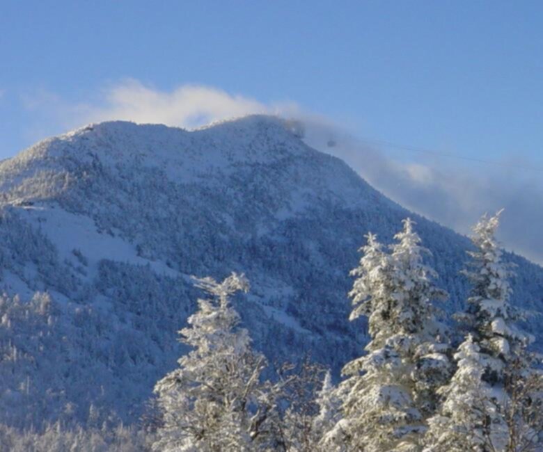
Lake Willoughby is one of those places in Vermont's Northeast Kingdom that stops you in your tracks the first time you see it. Tucked between two steep ridgelines — Mount Pisgah to the east and Mount Hor to the west — the lake sits in a glacially carved fjord-like valley that looks more like something out of Scandinavia than New England. It's dramatic, it's wild, and it's genuinely one of the most striking natural landscapes in the entire state.
The lake itself is long and narrow, squeezed between cliffs that drop almost directly into the water. That geography isn't just visually impressive — it shapes the whole experience of being here. The trails that climb the surrounding ridges give you views straight down to the water below, and on a clear day, you can see for miles across the Northeast Kingdom's rolling hills and forests.
The Terrain
The hiking around Lake Willoughby is defined by those two flanking mountains. Mount Pisgah, on the eastern shore, is the more commonly hiked of the two. Its trails climb through mixed hardwood and boreal forest before breaking out onto open ledges with sheer drops toward the lake. The rock faces here are serious — this isn't a gentle stroll, and some sections involve scrambling over exposed bedrock. Footing can be tricky, especially when wet.
Mount Hor, on the western side, is quieter and a bit less trafficked. The terrain is similarly rugged, with forested climbs leading to open viewpoints. Together, the two mountains form a natural gateway — the lake passes between them like water through a notch, and standing on either summit, you get a full sense of just how tight and deep that gap really is.
The cliffs along the eastern shore of the lake are well known among peregrine falcon enthusiasts. These birds nest on the rock faces seasonally, and their presence is a reminder of how intact and undisturbed this ecosystem remains. Keep your eyes on the cliff walls — spotting a peregrine in flight here is a legitimate highlight.
What Makes This Place Stand Out
In a region full of beautiful lakes and forested ridges, Lake Willoughby earns a different category. The combination of deep cold water, vertical cliffs, and the narrow valley orientation creates a microenvironment unlike anything else in Vermont. The lake is known for being exceptionally clear and cold — it's one of the deepest lakes in the state — and that depth contributes to the almost surreal blue-green color of the water when you look down from the trails above.
The Northeast Kingdom as a whole is one of the least developed corners of Vermont, and that remoteness is part of what makes Lake Willoughby feel so authentic. There's no resort infrastructure here, no crowds of the kind you'd find at more accessible destinations. What you get instead is a place that rewards the effort of getting there and climbing its ridges.
The light in the late afternoon, when the sun drops behind Mount Hor and the eastern cliffs fall into shadow while the water still catches the glow — that's the kind of thing that's hard to describe but easy to remember.
Access and Parking
The main access points for hiking around Lake Willoughby are off Route 5A, which runs along the western shore of the lake. Trailheads for both Mount Pisgah and Mount Hor are accessible from this road. Parking is available at designated pullouts near the trailheads — these can fill up on busy summer weekends, so arriving earlier in the day is a practical move.
The road itself offers some of the best views of the lake without any hiking at all. Pulling over along Route 5A and looking south down the length of the lake, framed by the two ridgelines, gives you an immediate sense of the scale of the place.
Flora and Wildlife
The forests around Lake Willoughby transition between northern hardwoods — sugar maple, yellow birch, beech — and boreal species like balsam fir and white spruce as you gain elevation. That shift is noticeable as you climb, and the boreal sections near the summits have a different feel: quieter, more compressed, with the smell of spruce and the sound of wind through the canopy.
Beyond the peregrine falcons on the cliffs, the area supports a range of wildlife typical of Vermont's northern forests. White-tailed deer, black bear, moose, and a variety of songbirds are all present in the broader landscape. The lake itself supports cold-water fish species, including lake trout and landlocked salmon, which thrive in its deep, cold water.
Practical Notes
- Trail conditions: The trails on both Mount Pisgah and Mount Hor involve rocky, rooted terrain with some exposed scrambling sections. Proper footwear with ankle support is strongly recommended.
- Cliff edges: Several viewpoints along the Mount Pisgah trail are at the top of sheer cliffs dropping toward the lake. Stay well back from edges, especially with children or dogs.
- Peregrine falcon nesting: During nesting season, portions of the cliff-side trails on Mount Pisgah may be closed to protect nesting birds. Check current conditions before heading out.
- Weather: The Northeast Kingdom can see rapid weather changes, and the exposed ridgelines above the lake are no place to be caught in a thunderstorm. Check the forecast and start early.
- Swimming: There are public beach areas along Route 5A where swimming in the lake is possible. The water is cold even in midsummer.
- Leave No Trace: Pack out everything you bring in. The relative wildness of this area depends on visitors treating it with care.
Getting There
Lake Willoughby is located in Westmore, Vermont, in the heart of the Northeast Kingdom. The area is reached via Route 5A, which connects to the broader Vermont highway network. The nearest larger town is Newport to the north. Cell service in this part of Vermont can be limited, so downloading offline maps before you leave is a smart habit.
Recommended gear for this trail


Ready to go?
Everything you need to know before you goStarting Point
The easiest way to get to the start of the trails at the lake willoughby is to drive north on Route 5 from Newport, Vermont. The trailhead is located on the east side of the lake.
When?
How much?
- Hiking shoes Essential
- → Salomon Elixir Tour Mid WP · 203.38 $
- Layered clothing Essential
- Rain jacket Essential
- Trekking poles
- → Black Diamond Trail Ergo Cork · 69.99 $
- Headlamp
- → Petzl Actik Core 625 · 103.95 $
FAQ - Frequently asked questions
Everything you need to knowThe Essential Hiking Checklist
Everything you need for your next hike. Bilingual, printable, 1 page.
Download the free checklistSimilar hikes nearby
Discover other trails you might enjoy

Echo Lake Trail
Northeast Kingdom
Bluff mountain hiking trail head
Northeast Kingdom
Owls Head Mt.
Northeast Kingdom
Willoughby State Forest
Northeast Kingdom
Groton State Forest
Northeast Kingdom
Jay Peak
Northeast Kingdom
Hiking near Stowe
0 trails to explore ~59 km away
We work hard to provide the most up-to-date and error-free data possible. If something seems incorrect, let us know! Your contribution helps the whole community.
Hikers' opinions
Be the first to review!
No hiker has shared their experience yet. Share your impressions and help other hikers!