

Ready to explore Willoughby State Forest? Here's everything you need to know before you go!
Discover the trail
Oh no! We don't have any photos 😢
This trail hasn't been captured yet. Be the first to share your adventure!Trail description
Description
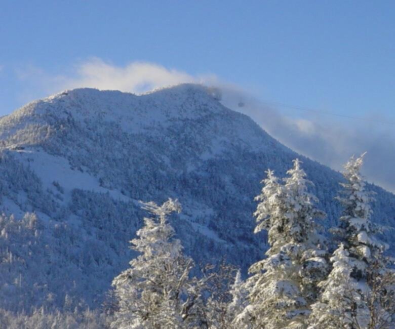
Willoughby State Forest is one of Vermont's most striking natural areas, tucked into the Northeast Kingdom where the landscape feels genuinely wild and largely untouched. The forest surrounds Lake Willoughby, a deep glacially carved lake flanked by dramatic cliffs that rise sharply from the water's edge — a combination you don't find many places in New England. If you're looking for a place that delivers real scenery without a crowd of thousands, this is it.
The Landscape
The defining feature of Willoughby State Forest is the geological drama of the area. Mount Pisgah and Mount Hor stand on opposite sides of Lake Willoughby, creating a narrow gap that channels the lake between sheer cliff faces. The cliffs on Mount Pisgah's eastern side drop hundreds of feet to the water below, and the views from the ridgeline are genuinely impressive — open, long, and oriented toward the surrounding Northeast Kingdom hills and beyond into Quebec.
The forest itself is a mix of northern hardwoods and boreal species. You'll move through stands of yellow birch, sugar maple, and beech at lower elevations, transitioning to spruce and fir as you gain elevation. The understory is dense in places, and the trails feel embedded in the forest rather than cut through it. This is a working state forest, so the landscape reflects both natural succession and managed timber areas in different zones.
The Trails
The trail network in Willoughby State Forest centers on the two main summits — Mount Pisgah and Mount Hor — with trailheads accessible from Route 5A along the lake's eastern shore. The trails on Mount Pisgah are the more heavily traveled of the two, offering cliff-edge viewpoints that reward the effort with some of the best lake-and-cliff scenery in Vermont. The South Trail and North Trail on Pisgah both lead to the summit ridge, with the South Trail being the more direct approach.
Mount Hor, on the western side of the lake, is quieter and slightly less visited. The trail to its summit passes through dense forest before opening up to views that look directly across at Pisgah's cliffs — a perspective that makes the scale of the whole formation click into place. Doing both mountains in a single day is possible for fit hikers and gives you the full picture of what makes this place special.
Beyond the two main summits, the state forest contains additional trail segments and old logging roads that see far less traffic. These are worth exploring if you want solitude and don't mind navigating with a map.
Wildlife and Natural Features
Willoughby State Forest is well known among birders, particularly for peregrine falcons that nest on the cliffs of Mount Pisgah. During nesting season, portions of the cliff trails may be closed to protect active nest sites — it's worth checking current conditions before you go. The area also supports a range of other raptors, and the boreal forest zones attract species that are harder to find further south in Vermont.
Lake Willoughby itself is one of the deepest lakes in Vermont, and its clarity is notable. From the cliff trails on Pisgah, you can look straight down to the water and get a real sense of the depth. The lake supports cold-water fish species, and the shoreline below the cliffs is accessible in places for those who want to get down to the water.
The forest floor in spring and early summer produces a good variety of wildflowers, particularly in the hardwood sections. Trout lily, trillium, and wild ginger appear in the right conditions, though the timing varies year to year.
Practical Information
The main trailheads for Mount Pisgah and Mount Hor are located along Route 5A, which runs along the eastern shore of Lake Willoughby. Parking is available at designated pullouts near the trailheads. The road itself is scenic and gives you a good preview of the cliffs before you even start hiking.
As a Vermont state forest, Willoughby is managed by the Vermont Department of Forests, Parks and Recreation. There is no entrance fee for day hiking. Dogs are generally permitted in state forests, but keep in mind that the cliff-edge sections of the Pisgah trails require care with pets — the terrain is exposed and the drop-offs are real.
The trails on both mountains involve meaningful elevation gain and some rocky, rooted terrain. Trekking poles are useful, particularly on the descent from Pisgah's south-facing slopes. Footwear with solid ankle support is a good idea, especially if conditions are wet. The cliff-edge sections require attention and are not suitable for young children without close supervision.
When to Visit
The Northeast Kingdom has a shorter hiking season than southern Vermont. Snow can linger on the upper trails into May, and early-season conditions can be muddy and unstable — Vermont's mud season is real and it affects trail surfaces significantly. Summer and fall are the prime windows, with fall foliage in the Northeast Kingdom typically peaking in late September to early October. The combination of the lake, the cliffs, and the hardwood color during peak fall is hard to beat.
Winter access is possible for those with the right gear, but the cliff sections become genuinely hazardous with ice and should only be attempted by experienced winter hikers with appropriate equipment.
What Makes It Worth the Drive
The Northeast Kingdom is a long way from most population centers, and Willoughby State Forest sits in one of the more remote corners of Vermont. That distance is part of what keeps it from being overrun. The combination of a deep glacial lake, dramatic cliff faces, and accessible summit trails with real views puts this place in a category of its own within the region. It's the kind of spot that hikers who've been there tend to bring up when someone asks for a Vermont recommendation — not the most famous, but often the most memorable.
Recommended gear for this trail


Ready to go?
Everything you need to know before you goStarting Point
The easiest way to get to the start of the trails at the willoughby state forest in Vermont is to take exit 8 off of I-91 and drive east on Route 2 for about 5 miles. The entrance to the forest will be on your left.
When?
How much?
- Hiking shoes Essential
- → Salomon Elixir Tour Mid WP · 203.38 $
- Layered clothing Essential
- Rain jacket Essential
- Trekking poles
- → Black Diamond Trail Ergo Cork · 69.99 $
- Headlamp
- → Petzl Actik Core 625 · 103.95 $
FAQ - Frequently asked questions
Everything you need to knowThe Essential Hiking Checklist
Everything you need for your next hike. Bilingual, printable, 1 page.
Download the free checklistSimilar hikes nearby
Discover other trails you might enjoy

Echo Lake Trail
Northeast Kingdom
Lake Willoughby
Northeast Kingdom
Bluff mountain hiking trail head
Northeast Kingdom
Owls Head Mt.
Northeast Kingdom
Groton State Forest
Northeast Kingdom
Jay Peak
Northeast Kingdom
Hiking near Stowe
0 trails to explore ~57 km away
We work hard to provide the most up-to-date and error-free data possible. If something seems incorrect, let us know! Your contribution helps the whole community.
Hikers' opinions
Be the first to review!
No hiker has shared their experience yet. Share your impressions and help other hikers!