

Ready to explore Groton State Forest? Here's everything you need to know before you go!
Discover the trail
Oh no! We don't have any photos 😢
This trail hasn't been captured yet. Be the first to share your adventure!Trail description
Groton State Forest sprawls across 26,164 acres of central Vermont's rugged landscape, creating one of the state's most diverse hiking destinations. This expansive wilderness sits between Montpelier and the Connecticut River valley, offering everything from gentle woodland walks to challenging mountain climbs. The forest's mix of dense hardwood stands, coniferous groves, pristine lakes, and rocky summits provides hikers with constantly changing scenery and terrain that showcases the best of Vermont's natural beauty.
The forest's trail network caters to every hiking preference and ability level. You'll find yourself moving through thick canopies of maple, birch, and beech trees that explode with color each fall, while spring brings wildflowers carpeting the forest floor. The terrain varies dramatically throughout the forest – some trails follow old logging roads with gentle grades, while others climb steep, rocky slopes that will test your endurance and reward you with sweeping views across the Northeast Kingdom.
Trail Network and Hiking Experience
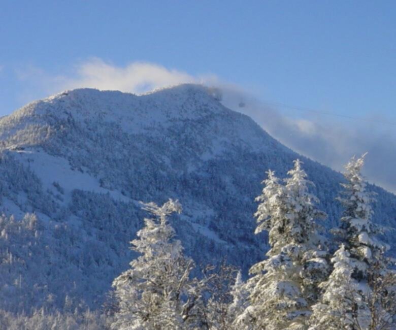
The Spruce Mountain Trail stands out as one of the forest's premier hiking destinations with a 4.7-star rating from over 1,000 hikers. This 6.9 km moderate hike features 355 m of elevation gain and rewards your effort with panoramic vistas that stretch across the surrounding forest canopy to distant mountain peaks. The trail climbs steadily through mixed forest, with the final approach involving some rocky scrambling before you reach the open summit. On clear days, the views encompass much of central Vermont's mountainous terrain, making it a favorite among photographers and peak baggers alike.
For a completely different experience, the Montpelier-Wells River Rail Trail follows a converted railroad bed through some of the forest's most scenic areas. This multi-use trail accommodates walkers, cyclists, and horseback riders on its gentle, well-maintained surface. The rail trail cuts through varied landscapes, from dense forest sections to open meadows, and crosses several streams and wetland areas where wildlife viewing opportunities abound.
The forest's trail system connects these main routes with numerous shorter paths and loop options, allowing you to customize your hiking experience based on your time and energy level. Many trails intersect near the lakes, creating opportunities for longer adventures that combine forest hiking with waterside breaks. The well-marked trail junctions make navigation straightforward, though carrying a map is always recommended for longer explorations.
Lakes and Water Features
Ricker Pond and Kettle Pond serve as focal points for both hiking and water-based activities within the forest. These pristine lakes offer perfect rest stops during longer hikes, with clear water reflecting the surrounding forest canopy. Both ponds provide excellent opportunities for kayaking, canoeing, and fishing, making them popular destinations for visitors who want to combine hiking with time on the water.
The lakes formed through glacial activity thousands of years ago, creating the deep, clear waters you see today. Their shores feature a mix of rocky outcrops and gentle slopes, with several trails providing access to different viewpoints around each lake's perimeter. The water remains refreshingly cool even in summer, offering swimming opportunities for those willing to brave the mountain lake temperatures.
Smaller streams and seasonal waterfalls add to the forest's aquatic appeal. During spring snowmelt and after heavy rains, these water features come alive, creating peaceful soundscapes that accompany your hiking experience. Several trails cross these waterways on well-maintained bridges, providing scenic photo opportunities and natural rest stops.
Wildlife and Natural Features
Groton State Forest supports an impressive variety of wildlife that hikers regularly encounter on the trails. White-tailed deer are common throughout the forest, often seen in early morning or evening hours browsing in clearings and along trail edges. Moose inhabit the area as well, particularly around wetland areas and lake shores. While moose sightings are less predictable, their tracks and signs appear frequently along many trails, especially in muddy areas near water sources.
The forest's bird population includes both resident and migratory species that change with the seasons. You'll hear the calls of various woodpeckers echoing through the trees, while hawks and occasionally eagles soar overhead. The diverse habitats – from dense forest to open water to rocky summits – support this rich variety of bird life throughout the hiking season. Early morning hikers often enjoy the most active wildlife viewing opportunities.
The geological features add another fascinating layer to your hiking experience. Glacial erratics – large boulders deposited by retreating ice sheets – dot the landscape like ancient sculptures, while exposed bedrock on higher elevations tells the story of the region's mountain-building processes. These rock formations provide natural landmarks and interesting geological study opportunities for curious hikers.
Camping and Extended Adventures
The forest provides multiple options for visitors wanting to extend their stay beyond day hiking. Rustic campsites scattered throughout the forest offer basic amenities for tent camping, allowing you to wake up surrounded by forest sounds and start your hiking adventures early in the morning when wildlife is most active.
For those preferring more comfort, cozy cabins provide shelter while maintaining the outdoor experience. These accommodations let you enjoy multiple days of hiking without sacrificing basic comforts, and their strategic locations provide easy access to various trailheads. The cabins are particularly popular during fall foliage season and should be reserved well in advance.
The camping areas near the lakes are especially sought after, combining forest camping with immediate water access. These sites fill up quickly during peak season, particularly on weekends when the fall foliage reaches its spectacular peak. The lakeside locations offer the added benefit of evening fishing opportunities and peaceful water views.
Seasonal Considerations and Trail Conditions
Groton State Forest's extensive size and elevation changes create varied conditions throughout the year that affect your hiking experience. The forest's elevation differences create microclimates where higher trails may have snow or muddy conditions while lower elevation paths remain clear and dry. The lake areas tend to be slightly warmer and more sheltered than exposed ridgelines, making them good options during cooler weather.
Spring brings the challenges of mud season to some routes, particularly those at higher elevations or in areas with poor drainage. However, this season also offers the reward of wildflowers, rushing streams, and the fresh green of emerging leaves. Fall transforms the forest into a spectacular display of color, with the mixed hardwood forest creating a tapestry of reds, oranges, and yellows that draws visitors from across the region.
Winter transforms the forest into a snow-covered landscape popular with snowshoers and cross-country skiers, though summer and fall remain the primary hiking seasons. The trail network's design allows for year-round enjoyment, with different routes offering optimal experiences depending on the season and your preferred activities.
Recommended gear for this trail


Ready to go?
Everything you need to know before you goStarting Point
The groton state forest is located in Groton, Vermont. To get to the start of the trails, take exit 9 off of I-89 and head east on VT-232. The forest will be on your left.
When?
How much?
- Hiking shoes Essential
- → Salomon Elixir Tour Mid WP · 203.38 $
- Layered clothing Essential
- Rain jacket Essential
- Trekking poles
- → Black Diamond Trail Ergo Cork · 69.99 $
- Headlamp
- → Petzl Actik Core 625 · 103.95 $
FAQ - Frequently asked questions
Everything you need to knowThe Essential Hiking Checklist
Everything you need for your next hike. Bilingual, printable, 1 page.
Download the free checklistSimilar hikes nearby
Discover other trails you might enjoy

Echo Lake Trail
Northeast Kingdom
Lake Willoughby
Northeast Kingdom
Bluff mountain hiking trail head
Northeast Kingdom
Owls Head Mt.
Northeast Kingdom
Willoughby State Forest
Northeast Kingdom
Jay Peak
Northeast Kingdom
Hiking near Montpelier
0 trails to explore ~23 km away
We work hard to provide the most up-to-date and error-free data possible. If something seems incorrect, let us know! Your contribution helps the whole community.
Hikers' opinions