


Ready to explore Glacier Peak? Here's everything you need to know before you go!
Discover the trail
Trail description
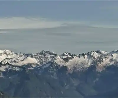
Glacier Peak is one of Washington's most remote and rewarding destinations for serious hikers. Standing as the fourth-highest summit in the state, this stratovolcano rises dramatically above the surrounding wilderness and demands real commitment from anyone who wants to get close to it. Unlike some of the more accessible Cascade volcanoes, Glacier Peak sits deep in the heart of the Glacier Peak Wilderness, which means the approach is long, the terrain is rugged, and the crowds are minimal. That combination is exactly what draws people here.
The Wilderness Setting
Glacier Peak sits within the Glacier Peak Wilderness, part of the larger Okanogan-Wenatchee and Mount Baker-Snoqualmie National Forests. The wilderness designation means no motorized vehicles, no mechanized equipment, and a landscape that feels genuinely wild. The mountain is surrounded by numerous active glaciers, and the terrain reflects that. You're moving through a landscape shaped by ice, with moraines, glacial streams, and rocky ridgelines defining the experience.
The Columbia Plateau region provides the broader geographic context here, where the volcanic history of the Pacific Northwest is written into every ridge and valley. Glacier Peak itself is an active stratovolcano, and while it's been quiet for centuries, the geology underfoot is a constant reminder of the forces that built this landscape.
What to Expect on the Trail
Getting to Glacier Peak is not a casual outing. Most routes require multiple days in the backcountry, and the trails leading toward the peak pass through dense old-growth forest before opening up into subalpine meadows and eventually alpine terrain. The transition between these zones is one of the highlights of any approach — the forest gives way gradually, the views open up, and the mountain reveals itself in stages rather than all at once.
Trail conditions vary significantly depending on the route and the time of year. Snow can linger well into summer at higher elevations, and stream crossings can be challenging during snowmelt. Hikers should be prepared for rapidly changing weather — the North Cascades are known for it — and should carry gear appropriate for cold, wet conditions regardless of the forecast.
The terrain around Glacier Peak rewards those who take their time. Ridgeline walks offer sweeping views of the surrounding peaks and valleys, and the glaciers visible from various vantage points are genuinely impressive. Wildlife is present throughout the wilderness, and the relative lack of foot traffic compared to more accessible destinations means encounters with deer, marmots, and birds of prey are common.
Backcountry Considerations
Because Glacier Peak sits in a designated wilderness area, Leave No Trace principles apply strictly. Camping is permitted in the backcountry, but site selection matters — camping on durable surfaces and away from water sources is expected, not optional. Bear canisters are strongly recommended given the active wildlife in the area, and in some zones they may be required depending on current land management guidelines.
Permits and regulations can change seasonally, so checking with the relevant ranger district before heading out is always a good idea. The wilderness sees enough use during peak summer months that popular campsites can fill up, and planning ahead makes a real difference.
Water sources are generally available along most approach routes, but all water should be treated before drinking. The glacial streams look clean, but giardia and other waterborne pathogens are present throughout the backcountry.
Access and Trailheads
There are several approach routes to Glacier Peak, each starting from different trailheads around the wilderness perimeter. The specific trailhead you choose will depend on which side of the mountain you want to explore and how much time you have. Road conditions to some trailheads can be rough, and a high-clearance vehicle is an asset on certain access roads. Checking current road conditions before departure is worth the few minutes it takes.
Parking at trailheads is generally available, though popular starting points can fill up on summer weekends. Arriving early in the morning is the most reliable way to secure a spot without stress.
Best Time to Visit
The window for hiking in the Glacier Peak Wilderness is relatively short. Snow typically closes higher routes until mid-summer, and fall weather can move in quickly by September. The sweet spot for most hikers is mid-July through early September, when trails are largely snow-free, wildflowers are at their peak in the subalpine meadows, and the days are long enough to cover serious ground. That said, conditions vary year to year, and a late snowpack can push the optimal window back by weeks.
Who This Is For
Glacier Peak is not the right destination for beginners or for anyone looking for a quick day hike with a big payoff. The terrain demands mountaineering skills and glacier travel competency, along with full wilderness self-reliance. The distances involved, the elevation gain, and the remoteness of the terrain all point toward experienced hikers who are comfortable with multi-day backcountry travel and self-sufficient in the wilderness. Navigation skills matter here — trails are generally well-marked, but the terrain is complex and conditions can change fast.
For hikers who are ready for it, Glacier Peak offers something genuinely rare: a major Cascade volcano that still feels like a true wilderness experience rather than a managed outdoor attraction. The effort required to reach it is part of what makes it worthwhile.
Recommended gear for this trail
As an Amazon Associate I earn from qualifying purchases.


Ready to go?
Everything you need to know before you goWhen?
How much?
As an Amazon Associate I earn from qualifying purchases.
Affiliate links — LGPO may earn a commission at no extra cost to you.
- Hiking shoes Essential
- → Salomon Elixir Tour Mid WP · 203.38 $
- Layered clothing Essential
- Rain jacket Essential
- Trekking poles
- → Black Diamond Trail Ergo Cork · 69.99 $
- Headlamp
- → Petzl Actik Core 625 · 103.95 $
FAQ - Frequently asked questions
Everything you need to know
25 hikes under 2 hours from Montreal
Distance, elevation, parking and season for each one. The ones we go back to ourselves.
Get the guideSimilar hikes nearby
Discover other trails you might enjoy
Hiking near Victoria
93 trails to explore ~171 km away
We work hard to provide the most up-to-date and error-free data possible. If something seems incorrect, let us know! Your contribution helps the whole community.
Hikers' opinions
Be the first to review!
No hiker has shared their experience yet. Share your impressions and help other hikers!